Texas State Highway 274
| ||||
|---|---|---|---|---|
 | ||||
| Route information | ||||
| Maintained by TxDOT | ||||
| Length | 23.002 mi[1] (37.018 km) | |||
| Existed | 1938–present | |||
| Major junctions | ||||
| South end |
| |||
| North end |
| |||
| Highway system | ||||
| ||||

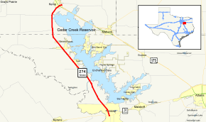
State Highway 274 or SH 274 is a Texas state highway that runs from Kemp south to Trinidad along the western side of Cedar Creek Reservoir. The route was designated on August 1, 1938 along its current route.[2]
Junction list
| County | Location | mi | km | Destinations | Notes |
|---|---|---|---|---|---|
| Henderson | Trinidad | ||||
| Tool | |||||
| Seven Points | |||||
| Kaufman | | ||||
| Kemp | |||||
| 1.000 mi = 1.609 km; 1.000 km = 0.621 mi | |||||
References
- ↑ Transportation Planning and Programming Division (n.d.). "State Highway No. 274". Highway Designation Files. Texas Department of Transportation. Retrieved 2008-04-06.
- ↑ (PDF) https://publicdocs.txdot.gov/minord/MinuteOrderDocLib/003676248.pdf. Missing or empty
|title=(help)
This article is issued from
Wikipedia.
The text is licensed under Creative Commons - Attribution - Sharealike.
Additional terms may apply for the media files.