Tyne Valley line
| Tyne Valley line | |
|---|---|
 | |
| Overview | |
| Other name(s) | Hadrian's Wall Country line |
| Type | Heavy rail |
| System | National Rail |
| Status | Operational |
| Locale | |
| Termini |
Carlisle Newcastle |
| Stations | 16 |
| Operation | |
| Commenced | 1834 |
| Opened | 18 June 1838 (complete route) |
| Completed | From 1835 (in stages) |
| Owner | Network Rail |
| Operator(s) | Northern |
| Rolling stock | |
| Technical | |
| Line length | 60 mi (97 km) |
| Number of tracks | Two |
| Track gauge | 1,435 mm (4 ft 8 1⁄2 in) standard gauge |
| Loading gauge | W7[1] |
| Operating speed | Mostly 60–65 mph (97–105 km/h)[1] |
The Tyne Valley line, built by the Newcastle & Carlisle Railway, is a railway line in northern England. The 60-mile (97 km) line was built in the 1830s, and links the city of Newcastle upon Tyne in Tyne and Wear with Carlisle in Cumbria. Formal opening took place on 18 June 1838. The line follows the course of the River Tyne through Northumberland. Five stations and two viaducts on the route are listed structures. The line is referred to in tourist publicity as the "Hadrian's Wall Country line."
Services
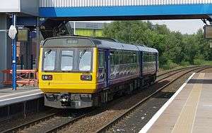
All passenger services on the Tyne Valley line are operated by Northern, although a handful of services which operate beyond Carlisle along the Glasgow South Western Line are operated using ScotRail stock - the train operating company (and crew) changes at Carlisle. Services are operated by diesel multiple units; Class 142 Pacers and Class 156 Super Sprinters which were introduced in the late 1980s. The line is also used for freight and is an important diversionary route during East Coast Main Line closures, although the line is not electrified.
History
The railway was built by the Newcastle and Carlisle Railway Company, the requisite Act of Parliament gaining Royal Assent on 22 May 1829. The line was built in sections from 1834 onwards. The first section (Hexham - Blaydon) opened in March 1835 but services were then suspended until May after a local landowner objected to the use of locomotives (specifically prohibited by the Act of Parliament).[2] The entire route between Carlisle London Road railway station and Redheugh in Gateshead was formally opened to passengers on 18 June 1838. A temporary Tyne bridge was built at Scotswood to allow trains to reach a terminus at Forth Banks in Newcastle - this opened on 21 October 1839. N&CR trains first used Newcastle Central railway station on 1 January 1851.
The N&CR was absorbed into the North Eastern Railway on 17 July 1862. From 1864, trains ran to Carlisle Citadel station, and the old London Road station was closed. In 1870, the temporary bridge at Scotswood was removed, and a new iron Scotswood Bridge was built to replace it.
In 1982, British Rail closed the Scotswood Bridge,[3] which had become uneconomic to maintain. Tyne Valley trains from Newcastle were diverted to use the present route, crossing the King Edward VII Bridge south-west of Newcastle Central Station, and running via Dunston to Blaydon, on an upgraded section of the original route along the south bank of the Tyne that had previously been freight-only since the 1850s.[4]
Tyne Valley Line | ||||||||||||||||||||||||||||||||||||||||||||||||||||||||||||||||||||||||||||||||||||||||||||||||||||||||||||||||||||||||||||||||||||||||||||||||||||||||||||||||||||||||||||||||||||||||||||||||||||||||||||||||||||||||||||||||||||||||||||||||||||||||||||||||||||||||||||||||||||||||||||||||||||||||||||||||||||||||||||||||||||||||||||||||||||||||||||||||||||||||||||||||||||||||||||||||||||||||||||||||||||||||||||||||||||||||||||||||||||||||||||||||||||||||||||||||||||||||||||||||||||||||||||||||||||||||||||||||||||||||||||||||||||||||||||||||||||||||||||||||||||||||||||||||||||||||||||||||||||||||||||||||||||||||||||||||||||||||||||||||||||||||||||||||||||||||||||||||||||||
|---|---|---|---|---|---|---|---|---|---|---|---|---|---|---|---|---|---|---|---|---|---|---|---|---|---|---|---|---|---|---|---|---|---|---|---|---|---|---|---|---|---|---|---|---|---|---|---|---|---|---|---|---|---|---|---|---|---|---|---|---|---|---|---|---|---|---|---|---|---|---|---|---|---|---|---|---|---|---|---|---|---|---|---|---|---|---|---|---|---|---|---|---|---|---|---|---|---|---|---|---|---|---|---|---|---|---|---|---|---|---|---|---|---|---|---|---|---|---|---|---|---|---|---|---|---|---|---|---|---|---|---|---|---|---|---|---|---|---|---|---|---|---|---|---|---|---|---|---|---|---|---|---|---|---|---|---|---|---|---|---|---|---|---|---|---|---|---|---|---|---|---|---|---|---|---|---|---|---|---|---|---|---|---|---|---|---|---|---|---|---|---|---|---|---|---|---|---|---|---|---|---|---|---|---|---|---|---|---|---|---|---|---|---|---|---|---|---|---|---|---|---|---|---|---|---|---|---|---|---|---|---|---|---|---|---|---|---|---|---|---|---|---|---|---|---|---|---|---|---|---|---|---|---|---|---|---|---|---|---|---|---|---|---|---|---|---|---|---|---|---|---|---|---|---|---|---|---|---|---|---|---|---|---|---|---|---|---|---|---|---|---|---|---|---|---|---|---|---|---|---|---|---|---|---|---|---|---|---|---|---|---|---|---|---|---|---|---|---|---|---|---|---|---|---|---|---|---|---|---|---|---|---|---|---|---|---|---|---|---|---|---|---|---|---|---|---|---|---|---|---|---|---|---|---|---|---|---|---|---|---|---|---|---|---|---|---|---|---|---|---|---|---|---|---|---|---|---|---|---|---|---|---|---|---|---|---|---|---|---|---|---|---|---|---|---|---|---|---|---|---|---|---|---|---|---|---|---|---|---|---|---|---|---|---|---|---|---|---|---|---|---|---|---|---|---|---|---|---|---|---|---|---|---|---|---|---|---|---|---|---|---|---|---|---|---|---|---|---|---|---|---|---|---|---|---|---|---|---|---|---|---|---|---|---|---|---|---|---|---|---|---|---|---|---|---|---|---|---|---|---|---|---|---|---|---|---|---|---|---|---|---|---|---|---|---|---|---|---|---|---|---|---|---|---|---|---|---|---|---|---|---|---|---|---|---|---|---|---|---|---|---|---|---|---|---|---|---|---|---|---|---|---|---|---|---|---|---|---|---|---|---|---|---|---|---|---|---|---|---|---|---|---|---|---|---|---|---|---|---|---|---|---|---|---|---|---|---|---|---|---|---|---|---|---|---|---|---|---|---|---|---|---|---|---|---|---|---|---|---|---|---|---|---|---|---|---|---|---|---|---|---|---|---|---|---|---|---|---|---|---|---|---|---|---|---|---|---|---|---|---|---|---|---|---|---|---|---|---|---|---|---|---|---|---|---|---|---|---|---|---|---|---|---|---|---|---|---|---|---|---|---|---|---|---|---|---|---|---|---|---|---|---|---|---|---|---|---|---|---|---|---|---|---|---|---|---|---|---|
| ||||||||||||||||||||||||||||||||||||||||||||||||||||||||||||||||||||||||||||||||||||||||||||||||||||||||||||||||||||||||||||||||||||||||||||||||||||||||||||||||||||||||||||||||||||||||||||||||||||||||||||||||||||||||||||||||||||||||||||||||||||||||||||||||||||||||||||||||||||||||||||||||||||||||||||||||||||||||||||||||||||||||||||||||||||||||||||||||||||||||||||||||||||||||||||||||||||||||||||||||||||||||||||||||||||||||||||||||||||||||||||||||||||||||||||||||||||||||||||||||||||||||||||||||||||||||||||||||||||||||||||||||||||||||||||||||||||||||||||||||||||||||||||||||||||||||||||||||||||||||||||||||||||||||||||||||||||||||||||||||||||||||||||||||||||||||||||||||||||||
Route
After leaving Newcastle the line originally ran along the north bank of the River Tyne for around 4 miles (6.4 km), serving the Sir W G Armstrong & Co works at Elswick, before crossing the Tyne at Scotswood and rejoining its current route along the south bank from Blaydon. Since 1982, after leaving Newcastle, the line crosses the Tyne on the King Edward VII Bridge and then diverges from the southbound East Coast Main Line passing west through Gateshead, with stations at Dunston, the MetroCentre and Blaydon.
At Wylam station, the line enters Northumberland. The station house at Wylam was built in 1835, and is Grade II* listed. The line continues along the south bank of the Tyne, with other stops in Northumberland at Prudhoe, Stocksfield, Riding Mill, Corbridge, Hexham, Haydon Bridge, Bardon Mill and Haltwhistle.
A diversion at Corbridge, opened on 27 May 1962, allowed straightening of the line to remove a 45 mph (70 km/h) speed limit and closure of the 510-foot (160 m) long tunnel, which was in need of further reinforcement.[5]
In Cumbria, the Tyne Valley line serves Brampton and Wetheral stations. The line then joins up with the Settle-Carlisle Railway just before reaching Carlisle.
Scotswood, Newburn & Wylam Railway
The Scotswood, Newburn and Wylam Railway (SN&WR) or the North Wylam Loop was a 6.5-mile (10.5 km) long double-track branch line constructed for colliery and passenger traffic. The line diverged from the original N&CR at Scotswood, ran along the north bank of the Tyne, with stations at Newburn, Lemington, Heddon-on-the-Wall and North Wylam, before crossing the River Tyne via the Wylam Railway Bridge and joining the N&CR again at the West Wylam Junction. The line followed the course of a waggonway between North Wylam and Lemington Staithes which had been in operation since 1748 and was used for taking coal from the collieries in Wylam and Walbottle to a part of the river which could be accessed by keel boats.[6]
On 16 June 1871 Parliament gave permission for the line to be built. Construction of the new line began in April 1872. On 12 July 1875 the line between Scotswood and Newburn was opened. It was operated by North Eastern Railway on behalf of SN&WR. On 13 May 1876 the line between Newburn and North Wylam opened. In October 1876 the final section of the branch between North Wylam and the West Wylam Junction opened.
On 15 September 1958, the stations at Newburn, Lemington and Heddon-on-the-Wall closed to passengers. with the latter also closing to goods on that day. On 4 January 1960 Lemington Station closed to goods traffic. Newburn station closed to goods traffic on 24 April 1965 with Scotswood station following two days later. Between 1965 and 1966 this line carried all rail traffic between Newcastle and Carlisle while a section of the main line between Scotswood and Blaydon was closed. Elswick closed to passengers on 2 January 1967 and Scotswood closed to passengers on 1 May 1967. The last station open—Wylam North—closed with the line on 11 March 1968.[7] The track between Newburn and Wylam Railway Bridge was removed in 1975 and the course was landscaped and made into a public bridleway. The track between Scotswood and Newburn remained to take rail traffic to and from Stella North Power Station and the Ever Ready factory in Newburn but the track was removed shortly after the Ever Ready factory closed in 1992.[8]
Branch lines
Originally the railway had four passenger branch lines leading off it:
- The Border Counties Railway branched off just west of Hexham and passed through Kielder and the North Tyne Valley, before joining up with the Scottish rail network at Riccarton Junction. It was also linked to the Wansbeck Valley Railway, which ran from Reedsmouth to Morpeth and connected to the branch line from Rothbury. The Border Counties line closed to passengers in 1956, and to all traffic in 1958 (five years before the Beeching Axe), although a small section of track between Reedsmouth and Bellingham was retained, accessed from the Wansbeck line, until the latter shut in the mid-1960s. Some of the trackbed is now lost beneath Kielder Reservoir, although the disused Kielder Viaduct remains a prominent local landmark.
- The Allendale branch ran south-west from Hexham Junction and was primarily used to carry minerals from mines and quarries around Allendale and the village of Langley. It was never popular, with passenger services ending in 1930 and closing completely in 1953.
- The Alston branch covered 17 miles (27 km) from the town of Haltwhistle. This branch provided a passenger service and also, in the early days, served the hundreds of lead mines in the upper South Tyne Valley. It included the monumental Lambley Viaduct and was the last of the branch lines to close in 1976. Part of the Alston end has been turned into a narrow gauge heritage railway, the South Tynedale Railway.
- There was a short branch (closed to passengers in 1923) from Brampton station into the town of Brampton itself. The junction of this railway (Brampton Junction) also linked to Lord Carlisle's Railway, a primarily industrial branch line pre-dating the Newcastle and Carlisle Railway itself, which also linked into the Alston branch at Lambley.
References
- 1 2 "Route Specifications: London North Eastern and East Midlands" (PDF). Network Rail. April 2017. Retrieved 8 March 2018.
- ↑ Hoole, Ken (1965). The North East - A Regional History of the Railways of Great Britain - Volume IV. Newton Abbot: David & Charles. p. 237. ISBN 0-7153-7746-9.
- ↑ Body, G: Railways of the Eastern Region Volume 2, 1988, Patrick Stephens Ltd, Wellingborough, ISBN 1-85260-072-1, p.133
- ↑ Bridges on the Tyne - Derwenthaugh www.bridgesonthe tyne.co.uk; Retrieved 2013-10-03
- ↑ Railway Magazine July 1962 p. 465 Cutting replaces tunnel at Corbridge
- ↑ "Wylam Waggonway". Hadrians Cycleway. Retrieved 3 July 2008.
- ↑ "North Wylam Branch". Northumbrian Railways. Retrieved 2008-06-25.
- ↑ "Glass and Gut". Timmonet. Retrieved 2008-07-03.
Further reading
- Butt, R. V. J. (1995). The Directory of Railway Stations. Sparkford: Patrick Stephens Ltd. ISBN 1-85260-508-1.
- Grainger, Richard (1836). A Proposal for Concentrating the Termini of the Newcastle & Carlisle, Great North of England & proposed Edinburgh Railways. Hodgson. A short pamphlet plus fold-out map. The original from which reference has been made is in the North of England Institute of Mining and Mechanical Engineers. It is reference Tracts vol 57 p200ff This contains a great deal about the early period of N&CR activity in Newcastle/Gateshead.
- Whittle, G. (1979). The Newcastle & Carlisle Railway. Newton Abbot: David & Charles. ISBN 0-7153-7855-4.
- Young, Alan (2003). Railways in Northumberland. Pudsey: Martin Bairstow. ISBN 1-871944-26-0.
External links
| Wikimedia Commons has media related to Tyne Valley Line. |
- British Railways in 1960 - Newcastle to Carlisle
- Railscot site for Newcastle and Carlisle Railway
- electronic copy of Tomlinson's History of the North Eastern Railway
| Primary to London |  | |
|---|---|---|
| Others | ||
| Heritage | ||
