Rothbury
| Rothbury | |
|---|---|
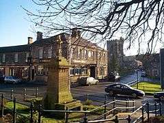 Rothbury town centre | |
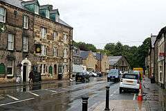 Looking east along Town Foot | |
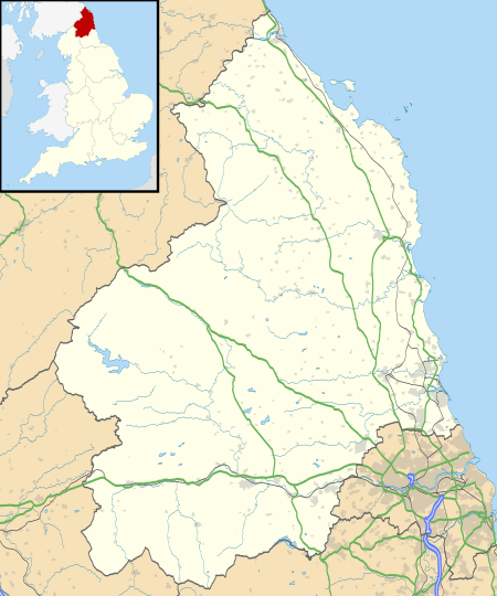 Rothbury Rothbury shown within Northumberland | |
| Population | 2,107 (2011) |
| OS grid reference | NU056017 |
| Civil parish |
|
| Unitary authority | |
| Ceremonial county | |
| Region | |
| Country | England |
| Sovereign state | United Kingdom |
| Post town | MORPETH |
| Postcode district | NE65 |
| Dialling code | 01669 |
| Police | Northumbria |
| Fire | Northumberland |
| Ambulance | North East |
| EU Parliament | North East England |
| UK Parliament | |
Rothbury is a town and civil parish in Northumberland, England. It is located on the River Coquet, 13.5 miles (21.7 km) northwest of Morpeth and 26 miles (42 km) north-northwest of Newcastle upon Tyne. At the time of the 2001 UK Census, Rothbury had a population of 1,740,[1] increasing to 2,107 at the 2011 Census.[2]
Rothbury emerged as an important town in the historic district of Coquetdale because of its situation at a crossroads over a ford along the River Coquet. Turnpike roads leading to Newcastle-upon-Tyne, Alnwick, Hexham and Morpeth allowed for an influx of families and the enlargement of the settlement during the Middle Ages. Rothbury was chartered as a market town in 1291, and became a centre for dealing in cattle and wool for the surrounding villages well into the Early Modern Period.
Today, the town is used as a staging point for recreational walking. Points of interest around Rothbury include: the Victorian mansion Cragside, the Simonside Hills and Northumberland National Park.
History
The first mention of Rothbury, according to a local history,[3] was in around the year 1100, as Routhebiria, or "Routha's town" ("Hrotha", according to Beckensall).[4] Fragments from an Anglo-Saxon cross, believed to be 8th century, are the only surviving relics pre-dating the Norman conquest. They are now in the town church and the University of Newcastle Museum. In 1201 King John signed the Rothbury Town Charter and visited Rothbury four years later.[5]
The village was retained as a Crown possession after the conquest, being made over to the Lords of Warkworth in 1204. Rothbury was a relatively important village in Coquetdale, being a crossroads situated on a ford of the River Coquet, with turnpike roads leading to Newcastle upon Tyne, Alnwick, Hexham and Morpeth. It was chartered as a market town in 1291, and became a centre for dealing in cattle and wool for the surrounding villages. A market cross was erected in 1722, but demolished in 1827. In the 1760s, according to Bishop Pococke, the village also had a small craft industry, including hatters. At that time, the village's vicarage and living was in the gift of the Bishop of Carlisle, and worth £500 per year.
Rothbury has had a turbulent and bloody history. In the 15th and 16th centuries the Coquet Valley was a pillaging ground for bands of Reivers who attacked and burned the town with terrifying frequency. Near the town's All Saints' Parish Church stands the doorway and site of the 17th century Three Half Moons Inn, where the Earl of Derwentwater stayed with his followers in 1715 prior to marching into a heavy defeat at the Battle of Preston.
Hill farming has been a mainstay of the local economy for many generations. Names such as Armstrong, Charleton and Robson remain well represented in the farming community. Their forebears, members of the reiver 'clans', were in constant conflict with their Scots counterpart. The many fortified farms, known as bastle houses, are reminders of troubled times which lasted until the unification of the kingdoms of England and Scotland in 1603.
Cragside
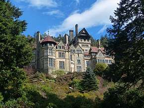
Rothbury is the site of Cragside, a Victorian country house built for the industrialist Sir William Armstrong, later Lord Armstrong of Cragside. The house was built as a "shooting box" (hunting lodge) between 1862 and 1865, then extended as a "fairy palace" between 1869 and 1900. The house and its estate are now in the possession of the National Trust and are often open to the public.
2010 Northumbria Police manhunt
In July 2010, Rothbury was the site of a major police manhunt for Raoul Moat, a murder suspect believed to be armed. The manhunt culminated in a stand-off between the police and Moat, which ended when Moat took his own life.
Governance
An electoral ward in the same name exists. This ward stretches from the Scottish Borders to Rothley. At the 2011 census it had a population of 5,316.[6]
Landmarks
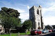
Rothbury's Anglican parish church building – All Saints' Church – dates from circa 1850, largely replacing but in parts incorporating the fabric of a former Saxon edifice, including the chancel, the east wall of the south transept and the chancel arch. The church has a font with a stem or pedestal using a section of the Anglo-Saxon cross shaft, showing what is reputed to be the earliest carved representation in Great Britain of the Ascension of Christ.[7]
The Anglo-Saxon cross is not to be confused with the market cross near the church, the current version of which was erected in 1902 and is known as "St Armstrong's Cross" as it was paid for by Lady Armstrong, widow of Lord Armstrong of Cragside.[8] Until 1965, Rothbury was the location of a racecourse, which staged only one meeting per year, in April.
Half a mile to the south, Whitton Tower is an exceptionally well-preserved 14th century pele tower.[9]
Lordenshaw Hill has the largest concentration of rock carvings in Northumberland. Over 100 panels have been recorded on the hill, the adjacent Whitton Burn and Garleigh Moor, in an area which covers less than 620 acres. The carved panels range from single cup-marked boulders to complex panels. There are many other interesting archaeological sites in this area, including a ditched Iron Age enclosure and an Early Bronze Age cairn.[10]
Transport
The town was the terminus of a branch line from Scotsgap railway station on the North British Railway line from Morpeth to Reedsmouth. The last passenger trains ran on 15 September 1952 and the line closed completely on 9 November 1963. The site of the former railway station is located to the south of the River Coquet and the old Station Hotel still stands near this site, now known as The Coquetvale Hotel.
The town is now served by an Arriva bus service which runs via Longframlington, Longhorsley, Morpeth and continues to Newcastle upon Tyne, the nearest city. PCL Travel, a local bus company, operates infrequent services to Alnwick. It also runs services roughly three times a day to Morpeth via Longframlington and Longhorsley.
References
- ↑ Office for National Statistics : Census 2001 : Parish Headcounts : Alnwick Retrieved 6 July 2010
- ↑ "Parish population 2011". Retrieved 1 July 2015.
- ↑ Frank Graham (1975) Rothbury and Coquetdale. Northern History Booklet No. 65. ISBN 0-85983-092-6.
- ↑ Stan Beckensall (2001) Northumberland The Power of Place. Tempus Publishing Ltd ISBN 0-7524-1907-2.
- ↑ "Chronology - Rothbury". rothbury.co.uk.
- ↑ "Ward population 2011". Retrieved 1 July 2015.
- ↑ ; see also
- ↑ Know your parish Archived 26 May 2010 at the Wayback Machine.
- ↑ "Whitton Tower". Pastscape. Retrieved 14 June 2011.
- ↑ "Walking With Rock Art – 7. Lordenshaw" at rockart.ncl.ac.uk Archived 15 April 2012 at the Wayback Machine.
External links
| Wikimedia Commons has media related to Rothbury. |
- Rothbury: The Village
- Rothbury Photos
- Northumbrian Railways
- Cragside – a National Trust Property
- GENUKI (Accessed: 7 November 2008)
- Northumberland Communities (Accessed: 7 November 2008)
Northumberland Portal | |
| Unitary authorities | |
| Major settlements | |
| Topics | |