Twin Falls Resort State Park
| Twin Falls Resort State Park | |
| West Virginia State Park | |
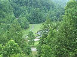 Golf course adjacent to the lodge. | |
| Country | United States |
|---|---|
| State | West Virginia |
| County | Wyoming |
| Elevation | 1,978 ft (602.9 m) |
| Coordinates | 37°37′25″N 81°27′33″W / 37.62361°N 81.45917°WCoordinates: 37°37′25″N 81°27′33″W / 37.62361°N 81.45917°W |
| Area | 3,776 acres (1,528.1 ha) |
| Established | 1964 [1] |
| - Opened | 1967 [1] |
| Owner | West Virginia Division of Natural Resources |
| IUCN category | III[2] |
| Nearest city | Pineville, West Virginia |
 Location of Twin Falls Resort State Park in West Virginia | |
| Website: wvstateparks | |
Twin Falls State Resort Park is a state park in Wyoming County, West Virginia. The park was opened in 1968 and was completed by 1975. The two namesake waterfalls are accessed by a hiking trail and are located about 1/2-mile apart[3] on the Marsh and Black Forks of Cabin Creek.[4]
The park is built on land donated by Pocahontas Land Corporation and Western Pocahontas Land Corporation as well as a few small privately owned plots. The entrance to Twin Falls State Park is about 12 miles (19 km)[5] from the Castle Rock Trailhead of the Hatfield–McCoy ATV Trail.[6]
The park's nature center, located in Twin Falls Lodge, features local and natural history displays and offers naturalist-led programs year round.
Features
- Twin Falls Lodge with 47 guest rooms
- 14 cottages
- Restaurant
- Nature center
- Gift shop
- 18 hole golf course
- 50 site campground (25 with RV hook-ups)
- Picnic grounds
- Hiking
- Mountain Biking[7]
- Tennis court
- Basketball court
- Volleyball court
- Indoor Pool Facility
- Fitness Center
- Bowers Ridge Pioneer Farm - a restored 1830s mountain homestead working farm
See also
References
- 1 2 Where People and Nature Meet: A History of the West Virginia State Parks. Charleston, West Virginia: Pictorial Histories Publishing Company. April 1988. ISBN 0-933126-91-3.
- ↑ "Twin Falls State Park". Protected Planet. IUCN. Retrieved 30 April 2018.
- ↑ Hiking trail map
- ↑ Get Outdoors web site, accessed July 25, 2006
- ↑ Castle Rock Trailhead, Hatfields-McCoy Trail web site, accessed July 25, 2006
- ↑ Hatfields-McCoy ATV Trail web site
- ↑ Outdoor Travels web site review, accessed July 26, 2006
External links
This article is issued from
Wikipedia.
The text is licensed under Creative Commons - Attribution - Sharealike.
Additional terms may apply for the media files.