Kober kayaran
Coordinates: 41°00′20″N 44°38′10″E / 41.00556°N 44.63611°E
| Kober kayaran Քոբեր կայարան | |
|---|---|
 Kober kayaran | |
| Coordinates: 40°58′24″N 44°41′19″E / 40.97333°N 44.68861°E | |
| Country | Armenia |
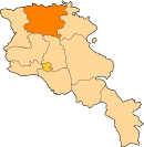
| Marz (Province) | Lori |
| Population (2011) | |
| • Total | 45 |
| Time zone | UTC+4 ( ) |
Kober kayaran (Armenian: Քոբեր կայարան), is a village in the Lori Province of Armenia. It belongs to the municipality of Tumanyan.[1] At the top of the tiny hillside village is Kobayr Monastery
References
This article is issued from
Wikipedia.
The text is licensed under Creative Commons - Attribution - Sharealike.
Additional terms may apply for the media files.