Shirakamut
Coordinates: 40°51′38″N 44°09′10″E / 40.86056°N 44.15278°E
| Shirakamut Շիրակամուտ | |
|---|---|
 Shirakamut | |
| Coordinates: 40°51′38″N 44°09′10″E / 40.86056°N 44.15278°E | |
| Country | Armenia |
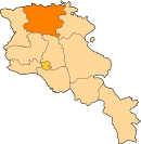
| Marz (Province) | Lori Province |
| Population (2008) | |
| • Total | 2,181 |
| Time zone | UTC+4 ( ) |
| • Summer (DST) | UTC+5 ( ) |
Shirakamut (Armenian: Շիրակամուտ; also, mistakenly, Shirakarnut; formerly, Nalband) is a town in the Lori Province of Armenia. The town was the epicenter of 1988 Armenian earthquake.
References
- Shirakamut at GEOnet Names Server
- World Gazeteer: Armenia – World-Gazetteer.com
- Report of the results of the 2001 Armenian Census, National Statistical Service of the Republic of Armenia
This article is issued from
Wikipedia.
The text is licensed under Creative Commons - Attribution - Sharealike.
Additional terms may apply for the media files.