Model, Colorado
| Model, Colorado | |
|---|---|
| Unincorporated community | |
 Looking south along U.S. Route 350 in Model. | |
 Location in Las Animas County and the state of Colorado  Model, Colorado (the US) | |
| Coordinates: 37°22′22″N 104°14′43″W / 37.37278°N 104.24528°WCoordinates: 37°22′22″N 104°14′43″W / 37.37278°N 104.24528°W | |
| Country |
|
| State |
|
| County | Las Animas[1] |
| Elevation[1] | 5,617 ft (1,712 m) |
| Time zone | UTC-7 (MST) |
| • Summer (DST) | UTC-6 (MDT) |
| ZIP code[2] | 81059 |
| Area code(s) | 719 |
| GNIS feature ID | 0204809 |
Model is an unincorporated community with a U.S. Post Office in Las Animas County, Colorado, United States. The Model Post Office has the ZIP Code 81059 [2] and has been in operation since 1912.[3] The community originally was a planned, or "model" community, hence the name.[4]
Geography
Model is located at 37°22′22″N 104°14′43″W / 37.37278°N 104.24528°W (37.372886,-104.245319).
References
- 1 2 "US Board on Geographic Names". United States Geological Survey. 2007-10-25. Retrieved 2008-01-31.
- 1 2 "ZIP Code Lookup". United States Postal Service. June 27, 2007. Archived from the original (JavaScript/HTML) on January 1, 2008. Retrieved June 27, 2007.
- ↑ "Post offices". Jim Forte Postal History. Retrieved 1 July 2016.
- ↑ Dawson, John Frank. Place names in Colorado: why 700 communities were so named, 150 of Spanish or Indian origin. Denver, CO: The J. Frank Dawson Publishing Co. p. 35.
Municipalities and communities of Las Animas County, Colorado, United States | ||
|---|---|---|
| City | 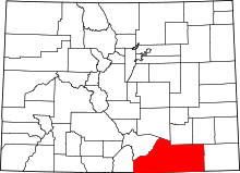 | |
| Towns | ||
| CDPs | ||
| Unincorporated communities | ||
| Ghost towns | ||
This article is issued from
Wikipedia.
The text is licensed under Creative Commons - Attribution - Sharealike.
Additional terms may apply for the media files.