Trans Canada Trail
| Trans Canada Trail | |
|---|---|
|
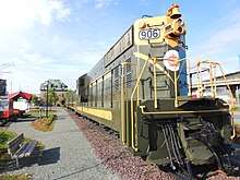
Trans Canada Trail pavilion in Fredericton, New Brunswick | |
| The Great Trail, formerly known as Trans Canada Trail | |
| Length | (As of 2018) 24,134 kilometres (14,996 mi) |
| Location | Canada |
| Established | 1992 |
| Completed | ?? |
| Trailheads | St. John's, Newfoundland and Labrador; Victoria, British Columbia; Tuktoyaktuk, Northwest Territories |
| Use | Hiking, biking, equestrianism, cross-country skiing, snowshoeing, canoeing |
| Elevation | |
| Highest point | 2,185 meters |
| Lowest point | Sea level |
| Grade | Variable |
| Hiking details | |
| Season | All seasons |
| Months | All seasons |
| Sights | Numerous |
| Hazards | Multiple |
| Surface | Variable |
| Right of way | Multiple |
| Website | http://thegreattrail.ca |
The Great Trail, formerly known as Trans Canada Trail, is a cross-Canada system of greenways, waterways and roadways that stretches from the Atlantic to the Pacific to the Arctic oceans. The Trail extends over 24,000 kilometres (15,000 miles); it is now the longest recreational, multi-use trail network in the world. The idea for the Trail began in 1992, shortly after the Canada 125 celebrations. Since then it has been supported by donations from individuals, corporations, foundations and all levels of government. [1][2]
Trans Canada Trail (TCT) is the name of the non-profit group that raises funds for the continued development of the Trail. However, the Trail is owned and operated at the local level.
On August 26, 2017, TCT celebrated the connection of the Trail with numerous events held throughout Canada. TCT has said it now plans to make the Trail more accessible, replace interim roadways with off-road greenways, add new spurs and loops to the Trail and fund emergency repairs when needed.
Origin of trail idea
The creation of the Trail was born of Canada's 125th anniversary celebrations in 1992.[3] It has its counterparts in such other greenway routes as the 12 EuroVelo routes, the UK's National Cycle Network, and the United States Numbered Bicycle Routes network.
Funding
It has been funded largely by Canadian federal and provincial governments, with significant contributions from corporate and individual donors. The first province to have completed its designated section of the trail was Prince Edward Island (see Confederation Trail).
Development and maintenance
The network of the Trans Canada Trail is made up of more than 400 community trails. Each trail section is developed, owned and managed locally by Trail groups, conservation authorities and by municipal, provincial and federal governments, for instance in parks such as Gatineau Park or along existing trails such as the Cataraqui Trail and Voyageur Hiking Trail. The Trans Canada Trail supports the construction and use of greenways to replace roadways.
Moreover, considerable parts of the Trail are repurposed defunct rail lines donated to provincial governments by Canadian Pacific and Canadian National Railway railbeds rebuilt as walking trails. As such, much of The Great Trail's development emulated the successful Rails-to-Trails initiative in the United States, whereby these transportation corridors are "rail banked" as recreational trails, allowing conversion back to rail should future need arise.
Thousands of Canadians, community partner organizations, corporations, local businesses and all levels of government are involved in developing and maintaining these trails. TCT does not own or operate any section of The Great Trail. As an ensemble, The Great Trail might be one of the largest volunteer projects ever undertaken in Canada.
Routes and amenities
The main section runs along the southern areas of Canada connecting most of Canada's major cities and most populous areas. There is also a long northern arm which runs through Alberta to Edmonton and then up through northern British Columbia to Yukon.
The Trail is multi-use and depending on the section may allow hikers, bicyclists, horseback riders, cross country skiers and snowmobilers. In theory, the Trail is equipped with regularly spaced pavilions that provide shelter as well as fresh water to travellers, but this varies widely from section to section, and particularly from province to province.
"Mile zero" of the Trail is located outside the Railway Coastal Museum in St. John's, Newfoundland.
Future developments
While the Trail is connected, TCT have said they will continue to fundraise for the future development and enhancement of the Trail. Among its objectives, TCT says it plans to replace interim roadways with off-road greenways, where possible, to make it safer and more accessible for all users, to add new Trail sections, and to provide emergency funding for Trail sections damaged by natural disasters, etc.
The Trail is not owned or operated by TCT, but the organization provides support to local partners and volunteer groups who maintain individual sections.
Infrastructure and route details by province
Newfoundland and Labrador
As of May, 2017[4], "Kilometre 0" begins at Cape Spear, the most easterly point in North America. Here it is known as the East Coast Trail, a series of rugged coastal wilderness paths. The route follows the coastline north around St. John's Bay and Freshwater Bay, connecting with the Grand Concourse walkway network at Fort Amherst. The route then follows a sidewalkway along Southside Road adjacent to St. John's Harbour until the former Trail Eastern Terminus located at the Railway Coastal Museum. From here It follows the former Newfoundland Railway route travelling south crossing Route 2 into Kilbride then through Bowring Park. Continuing north-west through Mount Pearl then Donovans crossing Route 1 into Paradise passing Neils Pond and Octagon Pond. The route then turns south-west in Conception Bay South and crosses Route 60 before it meets and follows the Conception Bay coastline. At Indian Pond, the Grand Concourse trail ends and the route is known as Newfoundland Trailway Park, an 883 km linear park which consists of the former railbed and which allows motorized access.
The route continues as the Newfoundland T'Railway south-west passing through the east side of Holyrood Bay. The trail passes through Briens as it enters Hollyrood. The route again crosses Route 60 then the North Arm River then travels north through Burnt Stump. The route travels south west passing Woodsford then passes through Brien's Gullies before then crossing Route 1 again. The route then passes through Brigus Junction, Mahers, then Ocean Pond then a mostly treed area before entering Whitbourne and crossing Route 80. Continuing the route crosses Route 100 then enters Placentia Junction before turning north passing over Coles Pond. Crossing Route 120, The next major location is Tickle Harbour Station where it again touches Route 1 and follows it crossing a few more times before entering Cobb's Pond then Come By Chance. The route continues as it enters Goobies, then Northern Blight, then crosses Route 1 as it enters Clarenville. The route follows Shoal Harbour River as it enters Thorburn Lake then crosses Route 233 as it Port Blandford then crosses Route 1 again as it enters Terra Nova.
The Trail changes to Gambo to Terra Nova Trail as it continues to Alexander Bay then route 1 then Route 320 as it enters Gambo.
Continuing north, the next leg of the trail is called Cobb Corridor Trail as it enters Butts then Benton then turning north-west as it enters Gander. As it continues, the route passes Glenwood then continues to Notre Dame Junction passing Route 340 and finally Norris Arm.
The next section is Newfoundland Trailway Park continuing to Rattling Brook, as it follows the Exploits River through Junipers Brook, Bishops Falls, Crossing Route 350 and continuing through Grand Falls.
Now known as Exploits Valley and Beothuk Trail the trail moves along into Windsor then Badger From here it is known as Newfoundland Trailway Park and travels through West Lake, Millertown Junction. the route passes through Quarry, Gaff Topsails, Kittys Brook, Howley where it crosses the Main Brook and ending in Deer Lake.
The next stretch is called the Deer Lake to Corner Brook Trail and pretty much follows Route 1 through Pasadena, Steady Brook and Corner Brook on the south side of the Upper Humber River ending as it crosses Route 450.
Continuing south, the route is now known as Newfoundland Trailway Park passing through Mount Moriah then continuing on Harrys River into Gallants then crossing Route 460 as it crosses Route 461 at Stephenville Crossing in St. George's Bay. Passing through St. George's, the route crosses Fischells Brook, then crosses Route 404 in Cartyville. Passing through St. Fintans, the route continues to Codroy Pond then South Branch, Benoits Siding, Doyles, Tompkins, St Andrews, and ending in Cape Ray.
The last stretch of the trail in Newfoundland is known as the Wreckhouse Trail. This trail passes through Osmond, Grand Bay, and ends in Port aux Basques where you would take the Port Aux Basques to North Sydney Ferry to North Sydney, Nova Scotia.
Nova Scotia
As the trail begins where it is known as Pottle Lake to North Sydney on the Cape Breton Island in the town of North Sydney separating itself from Highway 105 after the ferry ride from Newfoundland. As of June 2014, this portion of the route has not been completed however is planned to travel through the town and crossing Highway 125 following Old Branch Road on the North Side of Pottle Lake.
From here, the trail changes to Old Branch Road - George River Division continues through Georges River and continues south-east touching the north east corner of the Scotch Lake then enters the community of Scotch Lake and follows the Scotch Lake Rd.
The route continues as Upper Leitches Creek to Scotch Lake briefly merging with Route 223 on the Bras D'or Lakes Scenic Drive then follows the Upper Leitches Creek Rd as it enter Upper Leitches Creek.
The route changes to the Scotch Lake - Grand Narrows trail as it continues now on Tower Rd as it passes the MacAulays Lakes. The route here will cross McLeod Brook as it passes through the Bodale Hills. The Route changes to Little Narrows as it enters the community of Rear Christmas Island. The route again merges onto Highway 223 in Christmas Island and follows the Highway through Grand Narrows, Iona, Jamesville, Jamesville West, and Ottawa Brook. As the route passes Bras D'or Lake, it crosses at Little Narrows using the Little Narrows Ferry and crosses the Trans-Canada at Highway 105 in Aberdeen, then continues north through Lewis Mountain where it becomes the Celtic Shores Coast Trail.
Celtic Shores Coast Trail
The Trans Canada Trail continues passing Route 395 and passing through Scotsville to a fork north of Strathlorne.
North Trail
The North Path travels north and ends in Inverness.
South Trail
After passing through Strathlorne, the route passes Loch Ban then Black River where the route changes names to Mabou Rivers Trail. From here it passes through Glendyer then crosses Route 252 as it passes through Rankinville then crosses Route 19 in Mabou.
Prince Edward Island
Prince Edward Island's portion of The Great Trail is known as the Confederation Trail. The main trail runs from Tignish at kilometre 0 to Elmira at kilometre 273. Spurs extend to Charlottetown, Georgetown, Montague, Murray River, Murray Harbour, Souris, Wood Islands, and to the Confederation Bridge in Borden-Carleton which links the Island with New Brunswick on the Canadian mainland.
New Brunswick
Shogomoc River Pedestrian Bridge is a 265-foot suspension bridge in Canterbury, New Brunswick. Part of The Great Trail and the Sentier NB Trail network, it was opened in October 2011 by a ribbon cutting ceremony with Valerie Pringle present as a TCT representative. Sentier NB Trail provided over $300,000 towards the project. It is known as the final non-motorized trail link between the town of Grand Bay–Westfield and the border of the province of Quebec.
Quebec
Much of the Trail's current route follows the Route Verte and has many cycling routes. Completed off-road hiking trails can be found in Gatineau Park and along a route linking the Papineau-Labelle Nature Reserve, Mont Tremblant Provincial Park, and the Mastigouche Nature Reserve. These form part of a planned hiking route that would eventually link Ottawa-Gatineau on the Ontario border with the Gaspe Peninsula and the New Brunswick border.
Ontario
As a legacy project of 2015 Pan American Games and 2015 Parapan American Games, the Pan Am Path helps complete 250 kilometres (160 mi) gaps in Ontario's portion of the Trans Canada Trail.[5] In 2013, a one-kilometre-long honorary segment of The Great Trail was opened on the grounds of Rideau Hall in Ottawa. The Lake Huron-North Channel Waterfront route reduces use of shoulders along the Trans-Canada Highway by about 50 kilometres.
Prairie provinces
The route through Manitoba is a mix of off-road hiking trails, road shoulders, and waterways.
Saskatchewan has managed to avoid major highways and paved roads and uses nothing more than rural gravel roads to link off-road hiking trails. The route through this province has been claimed as complete with the opening of the Wakamow Valley Suspension Bridge. However, parts of the land route include some waterways that require a canoe or small boat.
The off-road sections of the trail are very fragmentary in Alberta, where opposition to the trail by some special interest groups has been very strong. A major section in Alberta follows highway 2A between Edmonton and Calgary, a road that combines narrow shoulders with heavy traffic. The main role of the Alberta government so far has been to assist local trail associations in searching for better routes.
British Columbia
The main leg of the trail enters British Columbia from Alberta, following the Elk River passing through Sparwood and the Kootenays and Columbia mountains. From there, it delves southward and westward near the Kettle river. The trail passes through the Okanagan Valley over the Kettle Valley Rail Trail, including the very popular Myra Canyon portion. From here, it heads through Princeton and continues west to Vancouver. Vancouver to Nanaimo involves a trip on BC Ferries. From Nanaimo, the trail extends southward as a mix of off-road trails and secondary roadways on Vancouver Island to Victoria where another ferry returns to Vancouver.
Photos
 Trans Canada Trail along Coal Harbour in downtown Vancouver, British Columbia
 Trans Canada Trail in Grand Forks, British Columbia
 Trans Canada Trail in Manitoba at Silver Springs Park viewed from Birds Hill, R.M. of East St. Paul
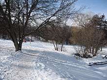 Trans Canada Trail in winter in Peterborough, Ontario
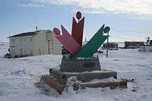 Trans Canada Trail marker in Tuktoyaktuk, Northwest Territories
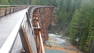 The newly restored Kinsol Trestle, which spans the Koksilah River on Vancouver Island.
See also
References
- ↑ "The Great Trail". Trans Canada Trail. Retrieved 28 January 2018.
- ↑ "Annual Report 2016–17" (PDF). Trans Canada Trail. 2017. p. 6. Retrieved 28 January 2018.
- ↑ Trans Canada Trail: The 18,000 kilometre dream, second edition, 2006
- ↑ Trans Canada Trail (2017-05-25). "Trans Canada Trail Partnership". Retrieved 2018-02-26.
- ↑ Pan Am and Parapan Am Trails
External links
| Wikimedia Commons has media related to Trans Canada Trail. |
| Wikivoyage has a travel guide for Trans Canada Trail. |
- Trans Canada Trail
- Moose Jaw, Saskatchewan section
- 9953km Trans Canada Trail diary and photos: Victoria to St Johns
- Unofficial Trans Canada Trail GPS Map
- Trans Canada trails in Manitoba
- A map of the entire trail