Rattling Brook, Newfoundland and Labrador
| Rattling Brook | |
|---|---|
| Village | |
 Rattling Brook Falls | |
| Country | Canada |
| Province | Newfoundland and Labrador |
| Population (2010) | |
| • Total | 90–110 |
| Time zone | UTC-3:30 |
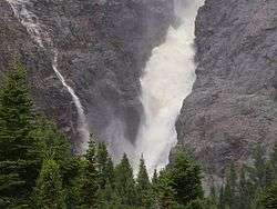
Rattling Brook is a small inlet coastal village located in North Central Newfoundland, close to Baie Verte, Springdale and other coastal towns nearby. Formerly a fishing village, its main residents are retirees and seasonal tourists. The town has a park at the base of Rattling Brook Falls, a 140-meter waterfall beneath a natural rock formation.
As of 2010, the current population rests between 90 and 110 persons with a small percentage of tourists making up the seasonal traffic.
The area in and around Rattling Brook is home to a diverse group of wildlife, both mammal and aquatic. During the summer months, species of fox, lynx and bear are not unusual. In the colder months, sealife observed in the bay area range from seals, humpback whales and several varieties of bird.
The unique microclimate of the area provides shelter from harsher winds, guarded by the surrounding groups of cliff and rock formation enveloping the area. Snowmobiling and skiing are very popular in the area with residents as well as tourists. In past decades, and due to climate shift, the bay had previously been noted for freezing nearly every winter, however that is no longer commonplace, although icebergs are not an unusual sight.
Seals and other amphibious and aquatic life have been seen in and about the area, providing tourists with photo opportunities. Bears and foxes are quite common as well.
Climate
Rattling Brook has a humid continental climate[1] (Köppen Dfb) with moderately warm summers and cold, snowy winters. For its latitude in Eastern Canada, Rattling Brook has highly moderated winters due to the proximity to the Atlantic Ocean.
| Climate data for Rattling Brook | |||||||||||||
|---|---|---|---|---|---|---|---|---|---|---|---|---|---|
| Month | Jan | Feb | Mar | Apr | May | Jun | Jul | Aug | Sep | Oct | Nov | Dec | Year |
| Record high °C (°F) | 15.5 (59.9) |
14.0 (57.2) |
17.0 (62.6) |
23.5 (74.3) |
30.0 (86) |
33.0 (91.4) |
34.0 (93.2) |
35.0 (95) |
32.0 (89.6) |
25.6 (78.1) |
21.1 (70) |
17.8 (64) |
35 (95) |
| Average high °C (°F) | −2.7 (27.1) |
−2.5 (27.5) |
1.2 (34.2) |
6.8 (44.2) |
13.4 (56.1) |
18.3 (64.9) |
22.9 (73.2) |
22.6 (72.7) |
17.6 (63.7) |
10.9 (51.6) |
5.0 (41) |
0.2 (32.4) |
9.5 (49.1) |
| Daily mean °C (°F) | −7.5 (18.5) |
−7.7 (18.1) |
−3.4 (25.9) |
2.4 (36.3) |
8.1 (46.6) |
12.6 (54.7) |
17.3 (63.1) |
17.2 (63) |
12.6 (54.7) |
6.7 (44.1) |
1.5 (34.7) |
−3.7 (25.3) |
4.7 (40.5) |
| Average low °C (°F) | −12.4 (9.7) |
−12.8 (9) |
−8.1 (17.4) |
−2.0 (28.4) |
2.8 (37) |
6.8 (44.2) |
11.6 (52.9) |
11.8 (53.2) |
7.6 (45.7) |
2.5 (36.5) |
−2.1 (28.2) |
−7.6 (18.3) |
−0.2 (31.6) |
| Record low °C (°F) | −32.8 (−27) |
−36.7 (−34.1) |
−32.0 (−25.6) |
−18.5 (−1.3) |
−9.4 (15.1) |
−3.5 (25.7) |
0.0 (32) |
−0.6 (30.9) |
−3.3 (26.1) |
−10.0 (14) |
−20.0 (−4) |
−33.3 (−27.9) |
−36.7 (−34.1) |
| Average precipitation mm (inches) | 95.0 (3.74) |
88.2 (3.472) |
91.0 (3.583) |
84.5 (3.327) |
86.9 (3.421) |
87.9 (3.461) |
90.6 (3.567) |
103.2 (4.063) |
111.2 (4.378) |
104.1 (4.098) |
99.6 (3.921) |
97.2 (3.827) |
1,139.6 (44.866) |
| Average snowfall cm (inches) | 70.8 (27.87) |
63.6 (25.04) |
54.7 (21.54) |
27.4 (10.79) |
3.7 (1.46) |
0.6 (0.24) |
0.0 (0) |
0.0 (0) |
0.0 (0) |
2.6 (1.02) |
20.5 (8.07) |
55.4 (21.81) |
299.3 (117.83) |
| Average precipitation days | 12.9 | 11.3 | 13.0 | 13.7 | 15.3 | 14.1 | 14.2 | 14.1 | 15.0 | 16.5 | 14.2 | 14.0 | 168.4 |
| Source: [2] | |||||||||||||
See also
References
- ↑ "Rattling Brook climate summary". Weatherbase. Retrieved 24 April 2018.
- ↑ "Rattling Brook, Newfoundland Canada Temperature Averages". Weatherbase. Retrieved 24 April 2018.
Coordinates: 49°37′N 56°11′W / 49.617°N 56.183°W