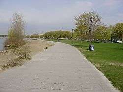
Waterfront Trail
| Waterfront Trail | |
|---|---|
 A sign demarcating The Waterfront Trail in Toronto | |
| Location | Southern Ontario, Canada |
| Trailheads | Niagara-on-the-Lake, Quebec border (near Cornwall, Ontario) |
| Use | Biking, hiking, inline skating |

The Waterfront Trail is made up of an interconnected series of trails mainly along the shores of Lake Ontario in Canada, beginning in Niagara-on-the-Lake, Ontario and extending to Brockville, Ontario, with an extension along Former Highway 2, to the Quebec provincial border. Through Toronto, the trail is called the Martin Goodman Trail. The Waterfront Trail is also used by commuters in parts of Southern Ontario.[1]
Expansion and future plans
In October 2013, Premier of Ontario Kathleen Wynne announced government support for expansion of the trail system to better connect the 2015 Pan Am Games venues and community.
"I want to ensure that all of the people of this province benefit from our investments in the Pan Am and Parapan Am Games, because that is how we can grow as One Ontario. Extending our trails system and connecting more communities is a great way for the excitement of the Games to live on well beyond 2015." Kathleen Wynne, Premier of Ontario, October 3rd, 2013[2]
The announcement ensures that "the province will work with First Nation and Métis communities and organizations to incorporate Aboriginal markers along the trails to honour the history and culture of Aboriginal communities in Ontario."
Trails will connect to four major Pan Am and Parapan Am Games venues – CIBC Pan Am/Parapan Am Athletes' Village, CIBC Pan Am Park, CIBC Hamilton Soccer Stadium and Pan Am/Parapan Am Fields.
All consultations related to Pan Am/Parapan Am trails will address accessibility requirements under the Accessibility for Ontarians with Disabilities Act.
In November 2013, two waterfront-design firms were selected to reimagine the space at the former Ontario Place grounds in Toronto to incorporate a broader mandate for greenspace and parkland.[3]
Uses
The rising cost of automobiles and gasoline mean a heavier burden on the trail system from multiple uses.
Controversial decisions to limit some e-bike and mobility scooters have been underway along portions of the trail.[4]
Cities

- Municipalities containing the Waterfront Trail
Notable waypoints
The rise of social travel and photography have parallelled with the rise of smaller wearable technological advancements that permits travelers along the trail a variety of activities and destinations.
Toronto Harbourfront
The jewel of the Waterfront Trail lies at the Toronto Islands Ferry Terminal where trail users can catch a ferry to the expansive Toronto Islands including Centre Island and Hanlon's Point Beach. In 2015, the Waterfront Trail is expected to connect to the huge underground Toronto PATH system. Cyclists and skaters are encouraged on the peaceful island where only utility vehicles are permitted.
Among the artistic touches of this portion of the trail include the architecturally renowned Wave Decks, designed by West8.[5]
The Beaches
The Beaches community in eastern Toronto is an important location on the trail, being one of the only neighbourhoods in Toronto with residential homes next to the lakeshore. The Beach itself is a popular destination, hosting games of beach volleyball, and attracting many cyclists and rollerbladers. North of the waterfront are many small stores and restaurants along Queen Street and The Danforth. From the Beaches, the trail, called the Martin Goodman Trail, runs west along the Toronto waterfront for its entire length, with only a few sections on city streets. Currently, there isn't any path running east along the waterfront from the Beaches.
Sugar Beach
Sugar Beach is a former parking lot located at Lower Jarvis Street and Queen's Quay—the park is now a non-swimming beach on the south-eastern edge of South Core, Toronto.
Port Credit
Port Credit straddles the Credit River with a mix of residential and commercial development along the trail. Most of the trail is separated from traffic with the exception of some residential streets at the east end near the Adamson Estate.
Spencer Smith Park
Spencer Smith Park at Burlington is a prime example of the evolution of mixed-use development and city planning in the Greater Toronto Area. In 2006, the park became a symbol of the ongoing effort to reclaim the Lake Ontario shoreline after the latest phase of redevelopment featured the opening of Spencer's, an upscale restaurant on grounds once occupied by the Mohawk Canoe Club. In 2013, a new pier was opened by the City of Burlington that anchors the trail along the shores of the lake.
Individuals and groups can sometimes be seen performing yoga, T'ai chi and other arts at the public gazebo here. In addition, Spencer Smith Park hosts the annual Sound Of Music festival, a longtime tradition and celebration for Halton and surrounding areas.
1000 Islands
The 1000 Islands Bikepath is a 37 kilometre trail running parallel to the Parkway between Gananoque and Brockville, forming a section of the Waterfront Trail.[6]
Ontario Place
In July 2014, the provincial government of Ontario announced a $100 million renovation plan that will see the transformation of Ontario Place from an entertainment venue into a huge mixed-use park that will anchor the trail in this section.[7]
Cycling on the trail
Unlike Quebec's extensive trail system - Route Verte - portions of the trail are inaccessible for safe travel for cyclists. There is an effort by the Waterfront Regeneration Trail, operators of the trail, to expand the cycling portions of the route.
"The Waterfront Regeneration Trail is focused on creating a cycling route around the Great Lakes, and has big expansion plans and dreams for the coming years to increase significantly its mileage. Some of the biggest deterrents for cycle tourists are poor road conditions that force cyclists into traffic and a lack of good signage."[8]
Facts and figures
Length
- 450 km (280 miles) designated (signed)
- 290 km (180 miles) undesignated (signage yet to be installed and/or gaps in alignment)
Includes
See also
Footnotes
- ↑ Trail usage at WaterfrontTrail.org
- ↑ Trail Expansion announcement. Retrieved 2013-10-03.
- ↑ When completed in 2015, the new park will link to the existing Waterfront Trail. "Design firm hired for Ontario Place urban park and waterfront trail". CityNews Toronto. 2013-12-11. Retrieved 2013-11-13.
- ↑ "City seeking new ways to regulate Hamilton's E-Bike explosion". Retrieved 2014-07-22.
- ↑ "Five signs of a revitalized Toronto waterfront". The Globe and Mail. 2014-07-25. Retrieved 2014-07-29.
- ↑ "1000 Islands Bikepath". Canada Trails. Retrieved 2008-02-12.
- ↑ "Ontario Place to get $100 million make-over". Blog TO. Retrieved 2014-08-04.
- ↑ "Is Canada missing the boat on cycling tourists?". CBC News. 2014-07-27. Retrieved 2014-07-29.
External links
| Wikimedia Commons has media related to Waterfront Trail. |
- The Waterfront Trail, official site
- The Waterfront Trail Artists
- Entry at Ontario Trails database
- City of Toronto cycling map
- Entry at Waymarked Trails, based on OpenStreetMap data.