Tinsukia
| Tinsukia | |
|---|---|
| City | |
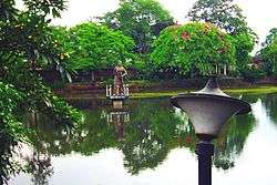 A view of the Tinikunia Pukhuri | |
 Tinsukia Location in Assam, India  Tinsukia Tinsukia (India) | |
| Coordinates: 27°30′00″N 95°22′01″E / 27.500°N 95.367°ECoordinates: 27°30′00″N 95°22′01″E / 27.500°N 95.367°E | |
| Country |
|
| State | Assam |
| District | Tinsukia |
| Government | |
| • Body | Tinsukia Municipality Board |
| Elevation | 116 m (381 ft) |
| Population (2011)[1] | |
| • Total | 99,448 |
| Languages | |
| • Official | Assamese |
| Time zone | UTC+5:30 (IST) |
| PIN | 786125 |
| Telephone code | 91-374 |
| ISO 3166 code | IN-AS |
| Vehicle registration | AS-23 |
| Website |
www |
Tinsukia (Pron: ˌtɪnˈsʊkiə) is an industrial city. It is situated 480 kilometres (298 mi) north-east of Guwahati and 84 kilometres (52 mi) away from the border with Arunachal Pradesh.
It is the administrative headquarters of Tinsukia District of Assam, India. It contains a mixture of indigenous Assamese communities, and Hindi-speaking people.
History
Tinsukia is the site of Bengmara, which was originally known as Changmai Pathar. It was the capital city of the Muttack Kingdom which was founded by Swargadeo Sarbananda Singha.[2]
Swargadeo Sarbananda Singha, known as Mezara, was a member of the erstwhile Chutia royal family and rose to become an able administrator. Mezara adopted the name Sarbananda Singha after he became the King. Swargadeo Sarbananda Singha introduced coins after his name and in Saka 1716 and 1717, he inscribed the title Swargadeo in the coins.
As instructed by Swargadeo Sarbananda Singha, his Minister Gopinath Barbaruah alias Godha dug a triangular pond which is known as Tinikunia Pukhuri. In 1884 a station was constructed near this pond, when the Dibru-Sadiya Rail line was laid, which was named as Tinsukia. Since then it has been known as Tinsukia.
Geography
Tinsukia is located at 27°30′N 95°22′E / 27.5°N 95.37°E.[3] It has an average elevation of 116 metres (380 feet).
Demographics
According to the India census, Tinsukia had a population of 1,25,216.[4] Males constituted 55% of the population and females 45%. Tinsukia had an average literacy rate of 70.15%, higher than the national average of 64.84%: male literacy was 77.89%, and female literacy 63.54%. 13.29% of the population was under 6 years of age.[5]
Politics
Tinsukia is part of Dibrugarh (Lok Sabha constituency).[6]
Transport
New Tinsukia Junction railway station is well connected with the other parts of the country
Important trains are
| Trains | Destinations |
|---|---|
| 13281/82 New Tinsukia - Rajendra Nagar Weekly Express | Patna and Tinsukia |
| 14055/56 Brahmaputra Mail | Delhi and Dibrugarh |
| 15603/04 Intercity Express | Ledo and Kamakhya Junction |
| 15959/60 Kamrup Express | Howrah Junction and Dibrugarh |
| Dibrugarh Rajdhani Express | New Delhi and Dibrugarh |
| 15927/29 New Tinsukia-Rangiya Express 22501/02 New Tinsukia-Bengaluru City | terminus |
|
12525/26 Dibrugarh Kolkata Superfast Express |
halt |
Media
Assamese daily Dainik Janambhumi published from Tinsukia along with Guwahati and Jorhat.
References
- ↑ http://www.censusindia.gov.in/pca/SearchDetails.aspx?Id=298235
- ↑ "Tinsukia". Retrieved 2 May 2012.
- ↑ Falling Rain Genomics, Inc - Tinsukia
- ↑ "Census of India / Assam / Tinsukia". Census of India. Retrieved 2 May 2012.
- ↑ "Census Of India". Retrieved 2 May 2012.
- ↑ "List of Parliamentary & Assembly Constituencies" (PDF). Assam. Election Commission of India. Archived from the original (PDF) on 2006-05-04. Retrieved 2008-10-06.
External links
| Wikimedia Commons has media related to Tinsukia. |
- Tinsukia district official website

| Topics | |||||||||||
|---|---|---|---|---|---|---|---|---|---|---|---|
| History | |||||||||||
| Administration | |||||||||||
| Districts and divisions |
| ||||||||||
| Geography | |||||||||||
| Culture | |||||||||||
| Arts, literature, music and cinema |
| ||||||||||
| People | |||||||||||
| Notable surnames |
| ||||||||||
| Urban areas | |||||||||||
| |||||||||||