Timeline of the 1985 Atlantic hurricane season
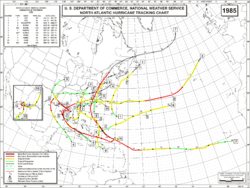
The 1985 Atlantic hurricane season featured eight landfalling tropical cyclones in the United States, including a record-tying six hurricanes, the most in a single year since 1916.[1][2] The season officially started on June 1 and lasted until November 30. These dates typically cover the period of each year when most tropical cyclones form in the Atlantic basin.[3] The season's first storm, Tropical Storm Ana, developed on July 15; the season's final storm, Tropical Depression Thirteen, dissipated on December 9.
The year featured average activity overall, with thirteen tropical cyclones, eleven tropical storms, seven hurricanes, and three major hurricanes.[4] The 1985 season was particularly destructive and disruptive for the United States, with damage amounting to a then-record US$4 billion. The entire coastline from Brownsville, Texas, to Eastport, Maine, was under a gale warning at some point during the year and a portion of every state was under a hurricane warning.[2]
For convenience, all information is listed by Coordinated Universal Time (UTC) first with the respective local time included in parentheses. This timeline includes information that was not operationally released, meaning that data from post-storm reviews by the National Hurricane Center is included. This timeline documents tropical cyclone formations, strengthening, weakening, landfalls, extratropical transitions, and dissipations during the season.
Events

June
- June 1
- The 1985 Atlantic hurricane season officially begins.[3]
July
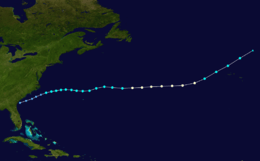
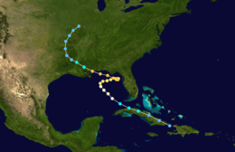
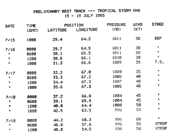
- July 15
- 18:00 UTC (2:00 p.m. AST) – Tropical Depression One forms approximately 200 mi (325 km) south-southeast of Bermuda.[5]
- July 16
- 18:00 UTC (2:00 p.m. AST) – Tropical Depression One strengthens into Tropical Storm Ana about 120 mi (195 km) southwest of Bermuda.[5]
- July 19
- 00:00 UTC (8:00 p.m. AST, July 18) – Tropical Storm Ana achieves its peak intensity with maximum sustained winds of 70 mph (110 km/h) and a minimum barometric pressure of 996 mbar (hPa; 29.42 inHg) roughly 25 mi (40 km) northwest of Sable Island, Canada.[5]
- 06:00 UTC (2:00 am AST) – Tropical Storm Ana transitions into an extratropical cyclone about 115 mi (185 km) east-southeast of Glace Bay, Nova Scotia.[5]
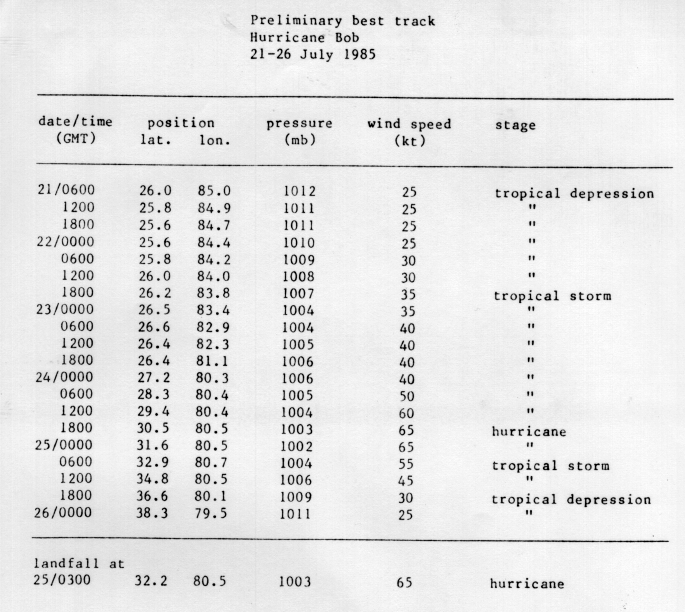
- July 21
- 06:00 UTC (2:00 a.m. EDT) – Tropical Depression Two forms over the southeastern Gulf of Mexico roughly 195 mi (310 km) west-southwest of Cape Coral, Florida.[6]
- July 22
- 18:00 UTC (2:00 p.m. EDT) – Tropical Depression Two strengthens into Tropical Storm Bob about 115 mi (185 km) west-southwest of Cape Coral, Florida.[6]
- July 23
- Between 12:00 and 18:00 UTC (between 8:00 a.m. and 2:00 p.m. EDT) – Tropical Storm Bob makes landfall near Bonita Springs, Florida with winds of 45 mph (70 km/h).[6]
- July 24
- 18:00 UTC (2:00 p.m. EDT) – Tropical Storm Bob intensifies into a Category 1 hurricane approximately 70 mi (110 km) east-northeast of Jacksonville, Florida.[6]
- July 25
- 00:00 UTC (8:00 p.m. EDT, July 24) – Hurricane Bob attains its peak intensity with winds of 75 mph (120 km/h) and a minimum pressure of 1002 mbar (hPa; 29.59 inHg) roughly 50 mi (85 km) southeast of Savannah, Georgia.[6]
- 03:00 UTC (11:00 pm EDT, July 24) – Hurricane Bob makes landfall near Beaufort, South Carolina, with winds of 75 mph (120 km/h).[6]
- 06:00 UTC (2:00 am EDT) – Hurricane Bob weakens to a tropical storm about 45 mi (75 km) west-northwest of Charleston, South Carolina.[6]
- 18:00 UTC (2:00 pm EDT) – Tropical Storm Bob degrades to a tropical depression roughly 40 mi (65 km) northwest of Greensboro, North Carolina.[6]
- July 26
- 00:00 UTC (8:00 pm EDT, July 25) – Tropical Depression Bob merges with a trough, marking its dissipation,[2] over the Appalachian Mountains along the Virginia–West Virginia border.[6]
August
- August 9
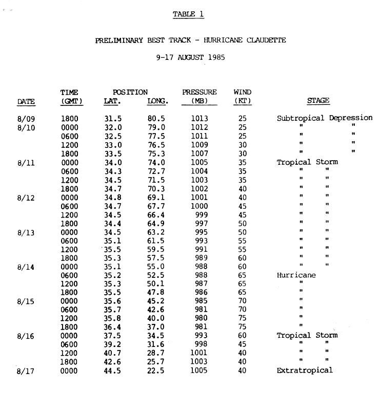
- 18:00 UTC (2:00 p.m. EDT) – A subtropical depression develops about 50 mi (85 km) southeast of Savannah, Georgia.[7]
- August 9
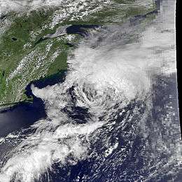
- 00:00 UTC (8:00 p.m. EDT, August 8) – The subtropical depression acquires a warm core, spiral banding, and gale-force winds. This marks its transition into a tropical cyclone and simultaneous classification as Tropical Storm Claudette roughly 130 mi (215 km) southeast of Hatteras, North Carolina.[7]
- August 12
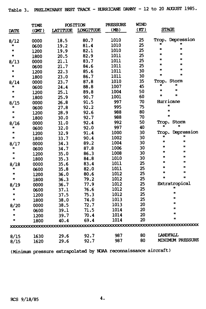
- August 12
- 00:00 UTC (8:00 p.m. EDT, August 11) – Tropical Depression Four forms about 65 mi (100 km) southeast of Grand Cayman, Cayman Islands.[8]
- August 13
- Around 06:00 UTC (2:00 a.m. EDT) – Tropical Depression Four brushes the Guanahacabibes Peninsula in Cuba before emerging over the Gulf of Mexico.[8]
- August 14
- 00:00 UTC (7:00 p.m. CDT, August 13) – Tropical Depression Four strengthens into Tropical Storm Danny roughly 450 mi (725 km) south-southeast of New Orleans, Louisiana.[8]
- August 14
- 06:00 UTC (3:00 a.m. ADT) – Tropical Storm Claudette attains hurricane-status about 725 mi (1,165 km) northeast of Bermuda.[7]
- August 15
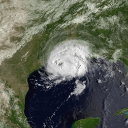
- 00:00 UTC (7:00 p.m. CDT, August 14) – Tropical Storm Danny intensifies into a hurricane roughly 235 mi (375 km) southwest of New Orleans, Louisiana.[8]
- 12:00 UTC (9:00 a.m. ADT) – Hurricane Claudette attains its peak intensity with winds of 85 mph (140 km/h) and a minimum pressure of 980 mbar (hPa; 28.94 inHg) approximately 540 mi (870 km) southwest of Flores Island, Azores.[7]
- 16:20 UTC (11:20 a.m. CDT) – Hurricane Danny attains its peak intensity with winds of 90 mph (150 km/h) and a minimum pressure of 987 mbar (hPa; 29.15 inHg) just southeast of Grand Chenier, Louisiana.[8]
- 16:30 UTC (11:30 a.m. CDT) – Hurricane Danny makes landfall near Grand Chenier, Louisiana, with winds of 90 mph (150 km/h).[8]
- August 16
- 00:00 UTC (9:00 p.m. ADT, August 15) – Hurricane Claudette weakens to a tropical storm about 220 mi 350 km southwest of Flores Island, Azores.[7]
- Around 06:00 UTC (3:00 a.m. ADT) – Tropical Storm Claudette passes close to or over Flores Island, Azores, with winds of 50 mph (85 km/h).[7]
- 00:00 UTC (7:00 p.m. CDT, August 15) – Hurricane Danny weakens to a tropical storm roughly 20 mi (35 km) south of Alexandria, Louisiana.[8]
- August 17
- 00:00 UTC (9:00 p.m. ADT, August 16) – Tropical Storm Claudette transitions into an extratropical cyclone about 460 mi (740 km) north-northeast of Terceira Island, Azores.[7]
- 12:00 UTC (7:00 a.m. CDT) – Tropical Storm Danny weakens to a tropical depression roughly 50 mi (85 km) northeast of Monroe, Louisiana.[8]
- August 19
- 00:00 UTC (8:00 p.m. EDT, August 18) – Tropical Depression Danny transitions into an extratropical cyclone about 20 mi (35 km) west of Emporia, Virginia.[8]
- August 28
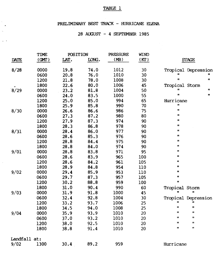
- 00:00 UTC (8:00 p.m. EDT, August 27) – Tropical Depression Five forms over the Windward Passage between Cuba and Haiti[9]
- Between 00:00 and 06:00 UTC (8:00 p.m. EDT, August 27 – 2:00 a.m. EDT, August 28) – Tropical Depression Five makes landfall near Cajobabo, Cuba, with winds of 35 mph (55 km/h).[9]
- August 28
- 18:00 UTC (2:00 p.m. EDT) – Tropical Depression Five strengthens into Tropical Storm Elena just southeast of Cifuentes, Cuba, while still over land.[9]
- August 29
- 00:00 UTC (8:00 p.m. EDT, August 28) – Tropical Storm Elena emerges over the Gulf of Mexico just north of Santa Cruz del Norte, Cuba.[9]
- 12:00 UTC (8:00 a.m. EDT) – Tropical Storm Elena strengthens into a hurricane roughly 205 mi (330 km) west-northwest of Key West, Florida.[9]
- August 30
- 12:00 UTC (7:00 a.m. CDT) – Hurricane Elena attains Category 2 status approximately 195 mi (320 km) south-southeast of Mobile, Alabama.[9]
September
- September 1
- 06:00 UTC (2:00 a.m. EDT) – Hurricane Elena strengthens into a Category 3 hurricane roughly 125 mi (205 km) south-southeast of Tallahassee, Florida as it executes an unusual clockwise loop over the northeastern Gulf of Mexico.[2][9]
- September 2
- 00:00 UTC (7:00 p.m. CDT, September 1) – Hurricane Elena attains its peak intensity with winds of 125 mph (205 km/h) and a minimum pressure of 953 mbar (hPa; 28.14 inHg) about 50 mi (85 km) south-southwest of Panama City, Florida.[9]
- September 2
- 13:00 UTC (8:00 a.m. CDT) – Hurricane Elena makes landfall near Gulfport, Mississippi, with winds of 115 mph (185 km/h).[9]
- 18:00 UTC (1:00 p.m. CDT) – Land interaction causes Hurricane Elena to rapidly weaken to tropical storm status about 15 mi (25 km) south of McComb, Mississippi.[9]
- September 3
- 06:00 UTC (1:00 a.m. CDT) – Tropical Storm Elena further degrades to a tropical depression roughly 15 mi (25 km) southwest of Ruston, Louisiana.[9]
- September 4
- September 8
- 12:00 UTC (3:00 a.m. ADT) – An unnumbered tropical depressions develops about 230 mi (370 km) northwest of Santo Antão, Cape Verde.[1]
- September 9
- 06:00 UTC (3:00 a.m. ADT) – The unnumbered tropical depression attains its maximum winds of 35 mph (55 km/h) roughly 385 mi (620 km) northwest of Santo Antão, Cape Verde.[1]
- September 11
- 12:00 UTC (9:00 a.m. ADT) – Tropical Depression Six develops about 10 mi (15 km) north of Tobago.[1]
- 18:00 UTC (3:00 p.m. ADT) – Tropical Depression Six attains its maximum sustained winds of 35 mph (55 km/h) roughly 30 mi (45 km) east of Grenada.[1]
- Between 18:00 and 00:00 UTC (3:00–9:00 p.m. ADT) – Tropical Depression Six makes landfall over Grenada with winds of 35 mph (55 km/h).[1]
- September 13
- September 15
- 1800 UTC (2:00 p.m. EDT) – Tropical Depression Seven developed 150 miles (240 km) north of Grand Turk Island.
October
- October 7
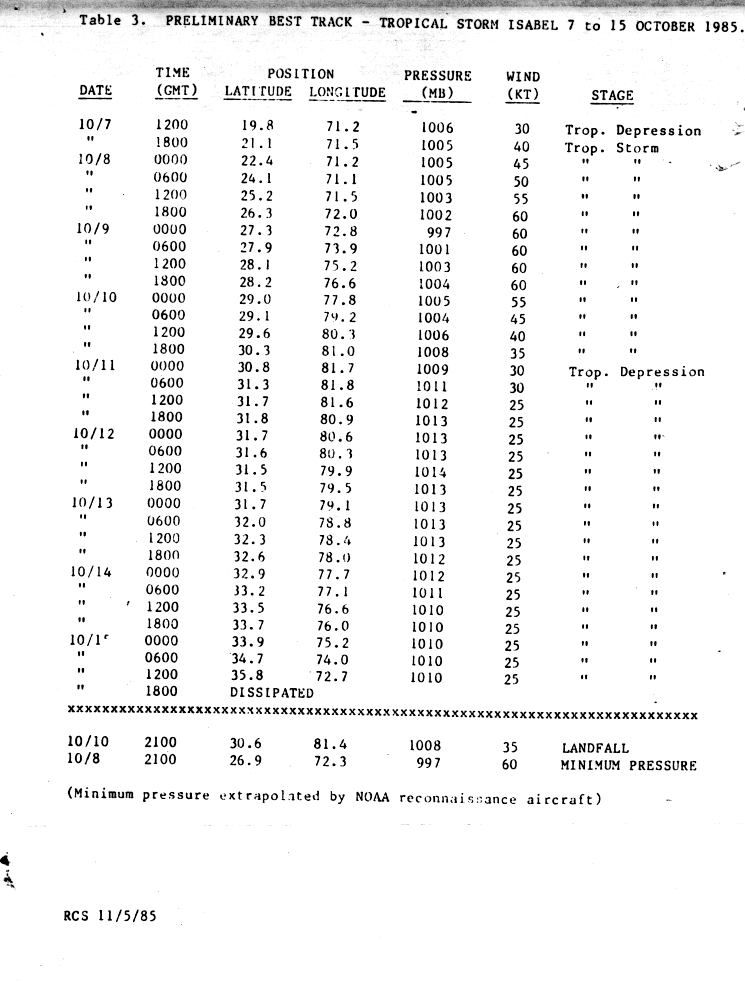
- 1200 UTC (8:00 a.m. AST) – Tropical Depression Ten developed near the coastline of the Dominican Republic province of Puerto Plata.[10]
- 1800 UTC (2:00 p.m. AST) – Tropical Depression Ten strengthens into Tropical Storm Isabel.[10]
- October 8
- 2100 UTC (5:00 p.m. AST) – Tropical Storm Isabel attains its peak intensity with winds of 70 mph (11 km/h) and a minimum pressure of 997 mbar (hPa; 29.44 inHg).[10]
- October 10
- 2100 UTC (5:00 p.m. EDT) – Tropical Storm Isabel made landfall near Fernandina Beach, Florida with winds of 40 mph (65 km/h).[10]
- October 11
- 0000 UTC (8:00 p.m. EDT October 10) – Tropical Storm Isabel weakens to a tropical depression.[10]
- October 15
- 1800 UTC (2:00 p.m. EDT) – Tropical Depression Isabel dissipated about 197 miles (317 km) east-southeast of Virginia Beach, Virginia.[10]
- October 26
- 0000 UTC (7:00 p.m. CDT October 25) – Tropical Depression Eleven developed about 250 miles (400 km) north-northwest of Mérida, Yucatán, Mexico.[1]
- 1200 UTC (7:00 a.m. CDT) – Tropical Depression Eleven strengthens into Tropical Storm Juan.[1]
- October 28
- 0000 UTC (7:00 p.m. CDT October 27) – Tropical Storm Juan strengthens into a Category 1 hurricane.[1]
- 1800 UTC (1:00 p.m. CDT) – Hurricane Juan attains its peak intensity with winds of 85 mph (140 km/h) and a minimum pressure of 971 mbar (hPa; 28.67 inHg).[1]
- October 29
- Shortly before 1200 UTC (7:00 a.m. CDT) – Hurricane Juan made landfall near Morgan City, Louisiana with winds of 80 mph (130 km/h).[1]
- 1800 UTC (1:00 p.m.) – Hurricane Juan weakened to a tropical storm.[1]
- October 31
- 0600-1200 UTC (1:00–7:00 a.m. CDT) – Tropical Storm Juan made landfall in Plaquemines Parish, Louisiana with winds of 65 mph (100 km/h).[1]
November
- November 30
- The 1985 Atlantic hurricane season officially ends.[3]
December
- December 7
- 1200 UTC (8:00 am EDT) – Tropical Depression Thirteen developed about 140 miles (230 km) west-northwest of Puerto Colombia, Colombia.[1]
- December 8
- 1200 UTC (8:00 am EDT) – Tropical Depression Thirteen attained its peak winds of 35 mph (55 km/h).[1]
- December 9
- 1800 UTC (2:00 pm EDT) – Tropical Depression Thirteen dissipated about 75 miles (121 km) west-northwest of Colón, Panama.[1]
See also
References
- 1 2 3 4 5 6 7 8 9 10 11 12 13 14 15 16 17 18 "Atlantic hurricane best track (HURDAT version 2)". Hurricane Research Division (Database). National Hurricane Center. May 1, 2018. Retrieved October 10, 2018.
- 1 2 3 4 Robert A. Case (July 1986). "Atlantic Hurricane Season of 1985" (PDF). Monthly Weather Review. Miami, Florida: American Meteorological Society. 114 (7): 1, 390–1, 405. Bibcode:1986MWRv..114.1390C. doi:10.1175/1520-0493(1986)114<1390:AHSO>2.0.CO;2. Retrieved January 19, 2016.
- 1 2 3 Christopher W. Landsea; Neal Dorst; Erica Rule (June 2, 2011). "G: Tropical Cyclone Climatology". Hurricane Research Division: Frequently Asked Questions. Atlantic Oceanographic and Meteorological Laboratory. National Oceanic and Atmospheric Administration. G1) When is hurricane season ?. Retrieved June 22, 2015.
- ↑ National Hurricane Center (June 5, 2009). "Tropical Cyclone Climatology". National Oceanic and Atmospheric Administration. Retrieved October 10, 2009.
- 1 2 3 4 Preliminary Best Track – Tropical Storm Ana 15–19 July 1985 (Report). Miami, Florida: National Hurricane Center. 1985. p. 3. Retrieved January 21, 2016.
- 1 2 3 4 5 6 7 8 9 Miles B. Lawrence (August 8, 1985). Preliminary Best Track – Hurricane Bob 21-26 July 1985. National Hurricane Center (Report). Miami, Florida: National Oceanic and Atmospheric Administration. p. 3. Retrieved February 28, 2016.
- 1 2 3 4 5 6 7 8 Harold B. Gerrish (September 29, 1985). Preliminary Best Track – Hurricane Claudette 9-17 August 1985. National Hurricane Center (Report). Miami, Florida: National Oceanic and Atmospheric Administration. p. 6. Retrieved February 28, 2016.
- 1 2 3 4 5 6 7 8 9 Robert C. Sheets (September 18, 1985). Preliminary Best Track – Hurricane Danny 12-20 August 1985. National Hurricane Center (Report). Miami, Florida: National Oceanic and Atmospheric Administration. p. 4. Retrieved February 28, 2016.
- 1 2 3 4 5 6 7 8 9 10 11 12 Preliminary Best Track – Hurricane Elena 28 August - 4 September 1985. National Hurricane Center (Report). Miami, Florida: National Oceanic and Atmospheric Administration. 1985. p. 4. Retrieved February 29, 2016.
- 1 2 3 4 5 6 Robert C. Sheets (1985). Preliminary Best Track – Tropical Storm Isabel 7 to 15 October 1985. National Hurricane Center (Report). Miami, Florida: National Oceanic and Atmospheric Administration. p. 3. Retrieved July 29, 2013.
| Preceded by 1983 |
Atlantic hurricane seasons timelines 1985 |
Succeeded by 1986 |