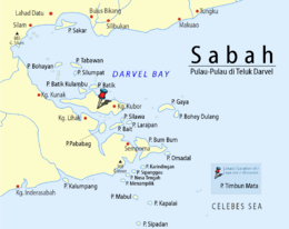
Timbun Mata
 Location of Timbun Mata Island in Darvel Bay | |
 Timbun Mata Island | |
| Geography | |
|---|---|
| Coordinates | 4°38′25″N 118°28′29″E / 4.64028°N 118.47472°ECoordinates: 4°38′25″N 118°28′29″E / 4.64028°N 118.47472°E |
| Administration | |
| State |
|
Timbun Mata Island (Malay: Pulau Timbun Mata) is the largest island on the south side of Darvel Bay, in Semporna, Sabah, Malaysia. It is over 26 kilometres long and at the widest is almost 10 kilometres wide. The island is mountainous and was formerly (pre-2000) densely wooded. Mt. Tannabalu, the highest point at 620 m., is a conical, extinct volcano located at the centre of the island. A secondary peak, Mt. Sedungal, at the east end of the island rises to 489 m. The south side of the island is only separated from the mainland by a shallow channel known as the Trusan Sigalong. It is located at 4°39' N 118°25' E with an area of 114.97 km².
History
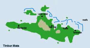
The island has been inhabited since before records were kept. There are several villages on the island which have been there for at least several hundred years, Mantandak (in the west), Lakai Lakai (north), Dap Dap (northeast) and Kubor (east). In addition there are newer, illegal settlements which have sprung up on the southeastern portion of the island.
The island was declared a forest reserve in 1930, but had been planted in teak as early as the 1880s. The teak forests have been periodically surveyed, but inroads by illegal logging and land clearing has reduced them.
See also
References
- United States Navy Publication 163, Chapter 10, prepared by the National Imagery and Mapping Agency.
- "Sabah Forestry Department report on Timbun Mata". 2005. Archived from the original on 10 March 2007.