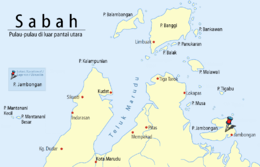
Jambongan Island
 Location of Jambongan Island in Sulu Sea | |
 Jambongan Island | |
| Geography | |
|---|---|
| Coordinates | 6°41′0″N 117°25′0″E / 6.68333°N 117.41667°ECoordinates: 6°41′0″N 117°25′0″E / 6.68333°N 117.41667°E |
| Administration | |
| State |
|
Jambongan Island (Malay: Pulau Jambongan) is located on the northern coast of Sabah in Malaysia. It is one of the largest island in Sabah located in Teluk Paitan (Paitan Bay) in the Sandakan Division. Jambongan town is located on the south-east of the island. The highest point on the island is Buli Gantungan Hill, at a height of 156 metres.[1]
Gallery
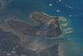 Jambongan Island seen from satellite
See also
References
- ↑ Sailing Directions (Enroute) - Borneo, Jawa, Sulawesi and NUsa Tenggara, United States Navy Publication 163, Sector 10 No. 10.67, 2002; accessed 6 February 2012
This article is issued from
Wikipedia.
The text is licensed under Creative Commons - Attribution - Sharealike.
Additional terms may apply for the media files.