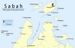
Banggi Island
 Location of Banggi Island between South China Sea and Sulu Sea | |
 Banggi Island | |
| Geography | |
|---|---|
| Coordinates | 7°15′0″N 117°10′0″E / 7.25000°N 117.16667°ECoordinates: 7°15′0″N 117°10′0″E / 7.25000°N 117.16667°E |
| Administration | |
| State |
|
| Demographics | |
| Population | 30,000 (2016) |
Banggi Island (Malay: Pulau Banggi) is located within the Kudat Division of Sabah in Malaysia. With an area of 440.7 square kilometres, it is the largest island in Malaysia followed by Bruit Island, Langkawi Island and Penang Island.[1] It is located off the northern coast of Sabah near Marudu Bay. The highest elevation on the island is a hill 529 metres high. As of 2016, it has an estimated population of 30,000.[1] Banggi's largest settlement is Limbuak. In 2014, a new township was proposed to be built in the island.[2] The island is also part of the gazetted area of Tun Mustapha Marine Park.[3]
See also
References
- 1 2 Roy Goh (7 September 2016). "Pulau Banggi deserves to reach its fullest potential". New Straits Times. Retrieved 26 February 2017.
- ↑ "Banggi Island to get new township". The Borneo Post. 9 March 2014. Retrieved 26 February 2017.
- ↑ Andrew Sia (17 August 2016). "Do you know where Malaysia's biggest marine park is?". The Star/Asia News Network. AsiaOne. Retrieved 26 February 2017.
External links
This article is issued from
Wikipedia.
The text is licensed under Creative Commons - Attribution - Sharealike.
Additional terms may apply for the media files.