Tyatya
| Tyatya | |
|---|---|
| Chachadake | |
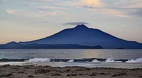 Tyatya in 2010, viewed from the south-west | |
| Highest point | |
| Elevation | 1,819 m (5,968 ft) [1] |
| Prominence | 1,819 m (5,968 ft) [2] |
| Listing | Ultra |
| Coordinates | 44°21′3″N 146°15′23″E / 44.35083°N 146.25639°ECoordinates: 44°21′3″N 146°15′23″E / 44.35083°N 146.25639°E [1] |
| Geography | |
 Tyatya | |
| Geology | |
| Mountain type | Stratovolcano / somma volcano |
| Last eruption | June 1981[1] |
Tyatya (Russian: Тятя, also spelled Tiatia and known as Chachadake (爺爺岳) in Japanese) is a volcano located in the northeastern part of Kunashir Island, Kuril Islands, Russia. It is the highest peak on the island with an elevation of 1,819 metres (5,968 ft).[1] Tyatya is one of the finest examples anywhere in the world of a somma volcano, a stratovolcano whose summit has collapsed to form a caldera which has then been mostly refilled by a new, younger volcanic cone which rises above the caldera rim.[1]
_Relief_Map%2C_SRTM-1.jpg)
Relief Map
See also
References
- 1 2 3 4 5 "Tiatia". Global Volcanism Program. Smithsonian Institution.
- ↑ "Russia: Kamchatka and the Russian Pacific Islands" Peaklist.org. Retrieved 2013-03-23.
External links
| Wikimedia Commons has media related to Tyatya. |
- Chachadake (Tiatia): Global Volcanism Program - Smithsonian Institution
- Chachadake - Japan Meteorological Agency (in Japanese)
- "Chachadake: National catalogue of the active volcanoes in Japan" (PDF). - Japan Meteorological Agency
- Chacha Dake (Tyatya) - Geological Survey of Japan
| Islands | |
|---|---|
| Volcanoes |
|
| Other geographical features | |
| Cities and towns | |
| Events | |
| People | |
| |
This article is issued from
Wikipedia.
The text is licensed under Creative Commons - Attribution - Sharealike.
Additional terms may apply for the media files.