Tao-Rusyr Caldera
| Tao-Rusyr Caldera | |
|---|---|
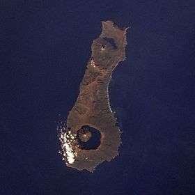 Onekotan Island, with Nemo Peak at top (north) and Tao-Rusyr Caldera at bottom. | |
| Highest point | |
| Elevation | 1,325 m (4,347 ft) |
| Coordinates | 49°21′N 154°42′E / 49.35°N 154.70°E |
| Geography | |
 Tao-Rusyr Caldera | |
| Geology | |
| Mountain type | Stratovolcano / Caldera |
| Last eruption | November 1952 |
Tao-Rusyr Caldera (Russian: Тао-Русыр) is a stratovolcano located at the southern end of Onekotan Island, Kuril Islands, Russia. It has 7.5 km wide caldera formed during a catastrophic eruption less than 10,000 years ago (reported ages range from 5,550 to 9,400 Before Present). The waters of Kal'tsevoe Lake fill the caldera, along with a large symmetrical andesitic cone, Krenitsyn Peak, that rises as an island within the lake. This volcano was named after Captain Pyotr Krenitsyn of the Imperial Russian Navy.
The most recent eruption, in 1952, formed a small lava dome on the island's coast. Krenitsyn Peak has a summit crater 350 m wide and is the highest point of the volcano and on the entire Onekotan Island. Another caldera, Nemo Peak, lies at the northern end of the island, and it also contains a central cone and crater lake.
The caldera forming eruption yielded about 50–60 cubic kilometres (12–14 cu mi) of material and destroyed the upper parts of the pre-existing volcano.[1] The event has been potentially identified in the GISP2 ice core.[2]
The caldera forming eruption wiped out vegetation on southern Onekotan, and it took a long time for it to recover.[3] Only one historical eruption occurred at Tao-Rusyr, just after the 1952 Severo-Kurilsk earthquake.[4]
See also
References
- ↑ Bazanova, L. I.; Melekestsev, I. V.; Ponomareva, V. V.; Dirksen, O. V.; Dirksen, V. G. (1 May 2016). "Late Pleistocene and Holocene volcanic catastrophes in Kamchatka and in the Kuril Islands. Part 1. Types and classes of catastrophic eruptions as the leading components of volcanic catastrophism". Journal of Volcanology and Seismology. 10 (3): 151–169. doi:10.1134/S0742046316030027. ISSN 0742-0463.
- ↑ Fiedel, Stuart J.; Southon, John R.; Brown, Thomas A.; Zielinski, G. A.; Mayewski, P. A.; Meeker, L. D.; Whitlow, S.; Twickler, M. S.; Morrison, M.; Meese, D. A.; Gow, A. J.; Alley, R. B. (1995). "The GISP Ice Core Record of Volcanism Since 7000 B.C.". Science. 267 (5195): 256–258. doi:10.2307/2885907. JSTOR 2885907.
- ↑ Razjigaeva, Nadezhda G.; Ganzey, Larisa A.; Arslanov, Khikmat A.; Grebennikova, Tatyana A.; Belyanina, Nina I.; Mokhova, Ludmila M. (15 May 2011). "Paleoenvironments of Kuril Islands in Late Pleistocene–Holocene: Climatic changes and volcanic eruption effects". Quaternary International. 237 (1): 4–14. doi:10.1016/j.quaint.2011.01.008.
- ↑ Walter, Thomas R.; Amelung, Falk (1 June 2007). "Volcanic eruptions following M ≥ 9 megathrust earthquakes: Implications for the Sumatra-Andaman volcanoes". Geology. 35 (6): 539–542. doi:10.1130/G23429A.1. ISSN 0091-7613.
External links
- "Tao-Rusyr Caldera". Global Volcanism Program. Smithsonian Institution.
- Volcanic Activity and Recent Tephras in the Kuril Islands: Field Result during the International Kuril Island Project (IKIP) 2000
- Gorshkov, Georgii Stepanovich (1970). "Volcanoes of the Kurile Islands". Volcanism and the Upper Mantle. Springer, Boston, MA: 49–234. doi:10.1007/978-1-4684-1767-8_5.
| Islands | |
|---|---|
| Volcanoes |
|
| Other geographical features | |
| Cities and towns | |
| Events | |
| People | |
| |