Thyatira, Mississippi
| Thyatira | |
|---|---|
| Unincorporated community | |
 Thyatira Location within the state of Mississippi | |
| Coordinates: 34°38′2″N 89°45′20″W / 34.63389°N 89.75556°WCoordinates: 34°38′2″N 89°45′20″W / 34.63389°N 89.75556°W | |
| Country | United States |
| State | Mississippi |
| County | Tate |
| Elevation | 371 ft (113 m) |
| Time zone | UTC-6 (Central (CST)) |
| • Summer (DST) | UTC-5 (CDT) |
| ZIP code | 38668 |
| GNIS feature ID | 678741[1] |
Thyatira is an unincorporated community in eastern Tate County, Mississippi. It is approximately 11 miles east of the county seat of Senatobia and 21 miles west of Holly Springs in Marshall County. The main thoroughfare is Mississippi Highway 4. It is home to two of the oldest Churches of Christ on record in the state, both of which bear the same name: Thyatira Church of Christ. Its elevation is 371 feet (131 m).[1]
References
- 1 2 "Thyatira, Mississippi". Geographic Names Information System. United States Geological Survey. Retrieved 2007-12-30.
Municipalities and communities of Tate County, Mississippi, United States | ||
|---|---|---|
| City | 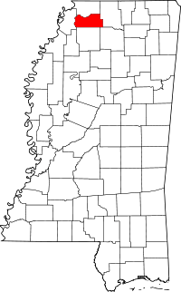 | |
| Town | ||
| Unincorporated communities | ||


This article is issued from
Wikipedia.
The text is licensed under Creative Commons - Attribution - Sharealike.
Additional terms may apply for the media files.