The Ville, St. Louis
| The Ville | |
|---|---|
| Neighborhood of St. Louis | |
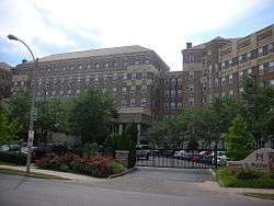 The Homer G. Phillips Hospital was built in 1937 to provide medical care to the black residents of a segregated city.[2] | |
 Location of the Ville within St. Louis | |
| Country | United States |
| State | Missouri |
| City | St. Louis |
| Wards | 4 |
| Government | |
| • Aldermen | Samuel L. Moore |
| Area | |
| • Total | 0.42 sq mi (1.1 km2) |
| Population (2010)[3] | |
| • Total | 1,868 |
| • Density | 4,400/sq mi (1,700/km2) |
| ZIP code(s) | Part of 63113 |
| Area code(s) | 314 |
| Website | stlouis-mo.gov |
The Ville is a historic African-American neighborhood located in North St. Louis, Missouri. It has had a long history of African-American businesses and residents.
This neighborhood is bounded by St. Louis Avenue on the North, Martin Luther King drive on the South, Sarah on the East and Taylor on the West.
Prior to the United States Civil Rights movement, the use of restrictive covenants and other legal restrictions prevented African Americans from finding housing in many areas of the city. As a result, the African--American population of St. Louis was concentrated in and around the Ville. The neighborhood was the site of a number of important cultural institutions for the black community, including Sumner High School, the first high school for black students west of the Mississippi River; and Homer G. Phillips Hospital, established in 1937 as one of the few black teaching hospitals in the United States and the only one in the city to serve blacks.
As of the 2010 Census, there are 1,868 people living in The Ville and 6,189 people in the surrounding Greater Ville neighborhood.[4]
Education
- Cote Brilliante Elementary School
- De La Salle Middle School at St. Matthew's
- Annie Malone's Emerson Therapeutic Academy (located in De La Salle Middle)
- Marshall School
- Simmons Elementary School
- Sumner High School
- Turner Middle School
- Williams Middle Community Education Center
Notable natives
Demographics
In 2010 The Ville's racial makeup was 97.3% Black, 1.2% White, 0.2% American Indian, and 1.3% Two or More Races. 0.8% of the people were of Hispanic or Latino origin.[5]
See also
- Peabody–Darst–Webbe, St. Louis neighborhood of another city hospital