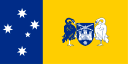
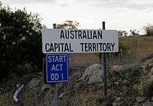
Australian Capital Territory
| Australian Capital Territory | |||||
|---|---|---|---|---|---|
| |||||
| Slogan or nickname | The Nation's Capital | ||||
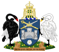
| Motto(s) | For the Queen, the Law, and the People | ||||
.svg.png) Other Australian states and territories | |||||
| Coordinates | 35°18′29″S 149°7′28″E / 35.30806°S 149.12444°ECoordinates: 35°18′29″S 149°7′28″E / 35.30806°S 149.12444°E | ||||
| Capital city | Canberra | ||||
| Demonym | Canberran | ||||
| Government | Constitutional monarchy | ||||
| • Chief Minister | Andrew Barr (ALP) | ||||
| Australian territory | |||||
| • Transferred to Commonwealth | 1911 | ||||
| • Responsible government | 1988 | ||||
| Area | |||||
| • Total |
2,358 km² (8th) 910 sq mi | ||||
| • Land |
2,280 km² 880 sq mi | ||||
| • Water |
77.6 km² (3.29%) 30 sq mi | ||||
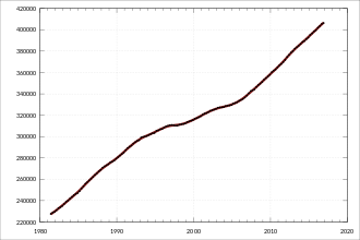
| Population (Mar 2018)[1] | |||||
| • Population | 419,200 (7th) | ||||
| • Density |
183.86/km² (1st) 476.2 /sq mi | ||||
| Elevation | |||||
| • Highest point |
Bimberi Peak 1,912 m (6,273 ft) | ||||
| • Lowest point |
Murrumbidgee River 429 m (1,407 ft) | ||||
| Gross territorial product (2009–10) | |||||
| • Product ($m) | $25,988[2] (6th) | ||||
| • Product per capita | $72,411 (2nd) | ||||
| Time zone(s) |
UTC+10 (AEST) UTC+11 (AEDT) | ||||
| Federal representation | |||||
| • House seats | 2/150 | ||||
| • Senate seats | 2/76 | ||||
| Abbreviations | |||||
| • Postal | ACT | ||||
| • ISO 3166-2 | AU-ACT | ||||
| Emblems | |||||
| • Floral | Royal bluebell[3] | ||||
| • Bird | Gang-gang cockatoo[4] | ||||
| • Colours | Blue and gold[5] | ||||
| Website |
www | ||||
The Australian Capital Territory (ACT; known as the Federal Capital Territory until 1938) is Australia's federal district, located in the south-east of the country and enclaved within the state of New South Wales. It contains Canberra, the capital city of Australia.
Geographically, the territory is bounded by the Goulburn-Cooma railway line in the east, the watershed of Naas Creek in the south, the watershed of the Cotter River in the west, and the watershed of the Molonglo River in the north-east. These boundaries were set to give the ACT an adequate water supply.[6] The Jervis Bay Territory, around the southern end of the Beecroft Peninsula, which is the northern headland of Jervis Bay, is also governed as if it were part of the ACT.
The need for a national territory was flagged by colonial delegates during the Federation conventions of the late 19th century. Section 125 of the Australian Constitution provided that, following Federation in 1901, land would be ceded freely to the new Federal Government. The territory was transferred to the Commonwealth by the state of New South Wales in 1911, two years prior to the naming of Canberra as the national capital in 1913. The floral emblem of the ACT is the royal bluebell and the bird emblem is the gang-gang cockatoo.[3][4]
The economic activity of the Australian Capital Territory is heavily concentrated around Canberra. A stable housing market, steady employment and rapid population growth in the 21st century have led to economic prosperity and in 2011 CommSec ranked the ACT as the second best performing economic region in the country.[7] This trend continued into 2016, when the territory was ranked the third best performing out of all of Australia's states and territories.[8] There is a higher proportion of young adults in the region compared with other Australian states or territories. Approximately one-fifth of ACT residents were born outside Australia, mainly in the United Kingdom. Almost one-fifth speak a language other than English at home, the most common being Chinese.[9]
Geography

The ACT is bounded by the Goulburn-Cooma railway line in the east, the watershed of Naas Creek in the south, the watershed of the Cotter River in the west, and the watershed of the Molonglo River in the north-east. The ACT extends about 88.5 kilometres (55.0 mi) North-South between 35-36S and 57.5 kilometres (35.7 mi) West-East at around 149.6E, although the city area occupies the north-central part of this area.
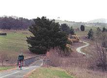
Apart from the city of Canberra, the Australian Capital Territory also contains agricultural land (sheep, dairy cattle, vineyards and small amounts of crops) and a large area of national park (Namadgi National Park), much of it mountainous and forested. Small townships and communities located within the ACT include Williamsdale, Naas, Uriarra, Tharwa and Hall.
Tidbinbilla is a locality to the south-west of Canberra that features the Tidbinbilla Nature Reserve and the Canberra Deep Space Communication Complex, operated by the United States' National Aeronautics and Space Administration (NASA) as part of its Deep Space Network.
There are a large range of mountains, rivers and creeks in the Namadgi National Park. These include the Naas and Murrumbidgee Rivers.
Climate
Because of its elevation at 650 metres (2,130 ft) and distance from the coast, the Australian Capital Territory experiences four distinct seasons, unlike many other Australian cities whose climates are moderated by the sea. Canberra is noted for its warm to hot, dry summers, and cold winters with occasional fog and frequent frosts. Many of the higher mountains in the territory's south-west are snow-covered for at least part of the winter. Thunderstorms can occur between October and March, and annual rainfall is 623 mm (24.5 in), with rainfall highest in spring and summer and lowest in winter.
The highest maximum temperature recorded in the ACT was 42.8 °C (109.0 °F) at Acton on 11 January 1939. The lowest minimum temperature was −14.6 °C (5.7 °F) at Gudgenby on 11 July 1971.[10]
The Australian government provides a current seven-day weather forecast for ACT.
Geology
Notable geological formations in the Australian Capital Territory include the Canberra Formation, the Pittman Formation, Black Mountain Sandstone and State Circle Shale.
In the 1840s fossils of brachiopods and trilobites from the Silurian period were discovered at Woolshed Creek near Duntroon. At the time, these were the oldest fossils discovered in Australia, though this record has now been far surpassed.[11] Other specific geological places of interest include the State Circle cutting and the Deakin anticline.[12][13]
The oldest rocks in the ACT date from the Ordovician around 480 million years ago. During this period the region along with most of Eastern Australia was part of the ocean floor; formations from this period include the Black Mountain Sandstone formation and the Pittman Formation consisting largely of quartz-rich sandstone, siltstone and shale. These formations became exposed when the ocean floor was raised by a major volcanic activity in the Devonian forming much of the east coast of Australia.
Governance
.jpg)
The ACT has internal self-government, but Australia's Constitution does not afford the territory government the full legislative independence provided to Australian states. Laws are made in a 25-member Legislative Assembly that combines both state and local government functions (prior to 2016, the Assembly was made up of 17 members).[14][15]
Members of the Legislative Assembly are elected via the Hare Clarke system.[16] The ACT Chief Minister (currently Andrew Barr, Australian Labor Party) is elected by members of the ACT Assembly. The ACT Government Chief Minister is a member of the Council of Australian Governments.[17]
Unlike other self-governing Australian territories (for example, the Northern Territory), the ACT does not have an Administrator.[18] The Crown is represented by the Australian Governor-General in the government of the ACT. Until 4 December 2011, the decisions of the assembly could be overruled by the Governor-General (effectively by the national government) under section 35 of the Australian Capital Territory (Self-Government) Act 1988, although the federal parliament voted in 2011 to abolish this veto power, instead requiring a majority of both houses of the federal parliament to override an enactment of the ACT.[19][20] The Chief Minister performs many of the roles that a state governor normally holds in the context of a state; however, the Speaker of the Legislative Assembly gazettes the laws and summons meetings of the Assembly.
In Australia's Federal Parliament, the ACT is represented by four federal members: two members of the House of Representatives represent the Division of Fenner and the Division of Canberra and it is one of only two territories to be represented in the Senate, with two Senators (the other being the Northern Territory). The Member for Fenner and the ACT Senators also represent the constituents of the Jervis Bay Territory.
In 1915 the Jervis Bay Territory Acceptance Act 1915 created the Jervis Bay Territory as an annexe to the Australian Capital Territory. In 1988, when the ACT gained self-government, Jervis Bay became a separate territory administered by the Australian Government Minister responsible for Territories, presently the Minister for Home Affairs.
An occasional misconception is that the ACT retains a small area of territory on the coast on the Beecroft Peninsula, consisting of a strip of coastline around the northern headland of Jervis Bay (not to be confused with the Jervis Bay Territory, which is on the southern headland of the Bay). However, though the land is owned by the Commonwealth Government, that area itself is still considered to be under the jurisdiction of New South Wales government, not a separate territory nor a part of the ACT.[21]
Administration
ACT Ministers implement their executive powers through the following government directorates:[22]
- Chief Minister, Treasury and Economic Development Directorate
- Community Services Directorate
- Health Directorate
- Education Directorate
- Environment, Planning and Sustainable Development Directorate
- Justice and Community Safety Directorate
- Transport Canberra and City Services Directorate
Demographics
As at 31 March 2018, the population of the ACT was 419,200[1] of whom most lived in Canberra. At the 2016 census the ACT median weekly income for people aged over 15 was $998 while the national average was $662.[23] The average level of degree qualification in the ACT is higher than the national average. Within the ACT 4.5% of the population have a postgraduate degree compared to 1.8% across the whole of Australia.
Urban structure
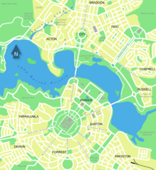
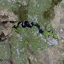
Canberra is a planned city originally designed by Walter Burley Griffin, a major 20th century American architect,[24] in collaboration with his wife Marion Mahony Griffin. Major roads follow a wheel-and-spoke pattern rather than a grid.[25] The city centre is laid out on two perpendicular axes: a water axis stretching along Lake Burley Griffin, and a ceremonial land axis stretching from Parliament House on Capital Hill north-eastward along Anzac Parade to the Australian War Memorial at the foot of Mount Ainslie.[26]
The area known as the Parliamentary Triangle is formed by three of Burley Griffin's axes, stretching from Capital Hill along Commonwealth Avenue to the Civic Centre around City Hill, along Constitution Avenue to the Defence precinct on Russell Hill, and along Kings Avenue back to Capital Hill.[26]
The larger scheme of Canberra's layout is based on the three peaks surrounding the city, Mount Ainslie, Black Mountain, and Red Hill. The main symmetrical axis of the city is along Anzac Parade and roughly[27] on the line[28] between Mount Ainslie and Bimberi Peak. Bimberi Peak being the highest mountain in the ACT approximately 52 km (32 mi) south west of Canberra . The precise alignment of Anzac parade is between Mount Ainslie and Capital Hill (formally Kurrajong Hill).
The Griffins assigned spiritual values to Mount Ainslie, Black Mountain, and Red Hill and originally planned to cover each of these in flowers. That way each hill would be covered with a single, primary colour which represented its spiritual value. This part of their plan never came to fruition. In fact, WWI interrupted the construction and some conflicts after the war made it a difficult process for the Griffins. Nevertheless, Canberra stands halfway between the ski slopes and the beach. It enjoys a natural cooling from geophysical factors.
The urban areas of Canberra are organised into a hierarchy of districts, town centres, group centres, local suburbs as well as other industrial areas and villages. There are seven districts (with an eighth currently under construction), each of which is divided into smaller suburbs, and most of which have a town centre which is the focus of commercial and social activities. The districts were settled in the following chronological order:
- North Canberra, mostly settled in the 1920s and '30s, with expansion up to the 1960s, now 14 suburbs
- South Canberra, settled from the 1920s to '60s, 13 suburbs
- Woden Valley, first settled in 1963, 12 suburbs
- Belconnen, first settled in 1967, 25 suburbs
- Weston Creek, settled in 1969, 8 suburbs
- Tuggeranong, settled in 1974, 19 suburbs
- Gungahlin, settled in the early 1990s, 18 suburbs although only 15 are developed or under development
- Molonglo Valley, first suburbs currently under construction
The North and South Canberra districts are substantially based on Walter Burley Griffin's designs.[26] In 1967 the then National Capital Development Commission adopted the "Y Plan" which laid out future urban development in Canberra around a series of central shopping and commercial area known as the 'town centres' linked by freeways, the layout of which roughly resembled the shape of the letter Y,[29] with Tuggeranong at the base of the Y and Belconnen and Gungahlin located at the ends of the arms of the Y.[29]
Development in Canberra has been closely regulated by government, both through the town planning process, but also through the use of crown lease terms that have tightly limited the use of parcels of land. All land in the ACT is held on 99 year leases from the national government, although most leases are now administered by the Territory government.
Most suburbs have their own local shops, and are located close to a larger shopping centre serving a group of suburbs. Community facilities and schools are often also located near local shops or group shopping centres. Many of Canberra's suburbs are named after former Prime Ministers, famous Australians, early settlers, or use Aboriginal words for their title.
Street names typically follow a particular theme; for example, the streets of Duffy are named after Australian dams and reservoirs, the streets of Dunlop are named after Australian inventions, inventors and artists and the streets of Page are named after biologists and naturalists. Most diplomatic missions are located in the suburbs of Yarralumla, Deakin and O'Malley. There are three light industrial areas: the suburbs of Fyshwick, Mitchell and Hume.
Education
Almost all educational institutions in the Australian Capital Territory are located within Canberra. The ACT public education system schooling is normally split up into Pre-School, Primary School (K-6), High School (7–10) and College (11–12) followed by studies at university or CIT (Canberra Institute of Technology). Many private high schools include years 11 and 12 and are referred to as colleges. Children are required to attend school until they turn 17 under the ACT Government's "Learn or Earn" policy.[30]
In February 2004 there were 140 public and non-governmental schools in ACT; 96 were operated by the Government and 44 are non-Government.[31] In 2005 there were 60,275 students in the ACT school system. 59.3% of the students were enrolled in government schools with the remaining 40.7% in non-government schools. There were 30,995 students in primary school, 19,211 in high school, 9,429 in college and a further 340 in special schools.[32]
As of May 2004, 30% of people in the ACT aged 15–64 had a level of educational attainment equal to at least a bachelor's degree, significantly higher than the national average of 19%.[33] The two main tertiary institutions are the Australian National University (ANU) in Acton and the University of Canberra (UC) in Bruce. There are also two religious university campuses in Canberra: Signadou is a campus of the Australian Catholic University and St Mark's Theological College is a campus of Charles Sturt University. Tertiary level vocational education is also available through the multi-campus Canberra Institute of Technology.
The Australian Defence Force Academy (ADFA) and the Royal Military College, Duntroon (RMC) are in the suburb of Campbell in Canberra's inner northeast. ADFA teaches military undergraduates and postgraduates and is officially a campus of the University of New South Wales while Duntroon provides Australian Army Officer training.
The Academy of Interactive Entertainment (AIE) offers courses in computer game development and 3D animation.
See also
Notes
- 1 2 "Australian Demographic Statistics, Mar 2018". 20 September 2018. Retrieved 13 October 2018. Estimated Resident Population 31 Mar 2018
- ↑ 5220.0 – Australian National Accounts: State Accounts, 2009–10.
- 1 2 Boden, Anne (23 May 2007). "Floral Emblem of the ACT". Archived from the original on 1 June 2007. Retrieved 27 May 2007.
- 1 2 "Australian Capital Territory". Archived from the original on 5 March 2007. Retrieved 27 May 2007.
- ↑ Time to Talk Canberra. "ACT Flags and Emblems". CMD.act.gov.au. Retrieved 17 July 2016.
- ↑ How were the ACT's boundaries determined?
- ↑ "Australian Capital Territory is Australia's best economy". International Business Times. 18 January 2011. Retrieved 11 February 2016.
- ↑ "CommSec State of the States places NSW economy first". 27 January 2016. Retrieved 22 June 2016.
- ↑ "Australian Capital Territory (A.C.T.)". Britannica. Retrieved 11 March 2016.
- ↑ Australian Bureau of Statistics, 2002 Yearbook of Australia Archived 12 October 2012 at the Wayback Machine., retrieved 22 July 2007
- ↑ Entry to the ACT Heritage Register – 20010. Woolshed Creek Fossil Site (PDF), ACT Heritage Council, archived from the original (PDF) on 22 October 2005
- ↑ "State Circle Cutting (Place ID 105733)". Australian Heritage Database. Department of the Environment.
- ↑ National Trust of Australia – Deakin Anticline, archived from the original on 6 July 2004
- ↑ Antony Green (22 September 2016). "Summary of Candidates and Parties Contesting 2016 ACT Election". ABC Elections.
- ↑ Three Levels of Law-Making, Parliamentary Education Office, archived from the original on 16 May 2013
- ↑ Factsheet – Hare-Clark electoral system, ACT Electoral Commission, 5 July 2012, archived from the original on 6 June 2013
- ↑ COAG Members, Council of Australian Governments, archived from the original on 19 July 2013
- ↑ "Territory Government", 1301.0 – Year Book Australia, 2012, Australian Bureau of Statistics, 24 May 2012, retrieved 21 October 2013
- ↑ "Disallowance powers removed from ACT self-government legislation". News, Events and Conferences. ACT Legislative Assembly. Archived from the original on 23 May 2012. Retrieved 5 November 2012.
- ↑ "Territories Self-Government Legislation Amendment (Disallowance and Amendment of Laws) Act 2011 (Cth)". ComLaw. Retrieved 14 September 2013.
- ↑ "Jervis Bay Territory Acceptance Act 1915". Retrieved 30 November 2015.
- ↑ ACT Government Information Portal, ACT Government Directorates
- ↑ Australian Bureau of Statistics (27 June 2017). "Australian Capital Territory". 2016 Census QuickStats. Retrieved 27 June 2017.

- ↑ Wigmore 1971, pp. 60–63.
- ↑ Wigmore 1971, p. 67.
- 1 2 3 Wigmore 1971, p. 64.
- ↑ Google Earth
- ↑ Wigmore 1971, p. 64-67.
- 1 2 Sparke 1988, pp. 154–155.
- ↑ Dept of Education & Training. 2011 Archived 10 April 2011 at the Wayback Machine.
- ↑ Australian Bureau of Statistics. 2005. Schools in the ACT
- ↑ ACT Department of Education and Training. 2005. Enrolments in ACT Schools 1995 to 2005 Archived 17 February 2006 at the Wayback Machine.
- ↑ Australian Bureau of Statistics. 2005. Education in the ACT
References
External links
- Statistical Subdivisions of the Australian Capital Territory

| General | ||
|---|---|---|
| City | ||
| Other settlements | ||
| Localities | ||
| Rivers | ||
Australian Capital Territory portal | ||