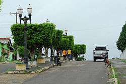
Rodrigues Alves, Acre
Coordinates: 07°44′31″S 72°38′49″W / 7.74194°S 72.64694°W
| Rodrigues Alves, Acre | |||
|---|---|---|---|
 | |||
| |||
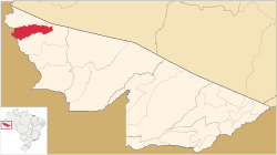 Location of municipality in Acre State | |||
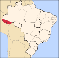
 Rodrigues Alves, Acre Location in Brazil | |||
| Coordinates: 07°44′31″S 72°38′49″W / 7.74194°S 72.64694°W | |||
| Country |
| ||
| State | Acre | ||
| Government | |||
| • Mayor | Sebastiāo Correia (PMDB) | ||
| Area | |||
| • Total | 1,276 sq mi (3,305 km2) | ||
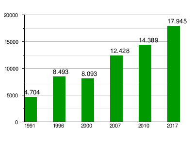
| Population (2017) | |||
| • Total | 17 945 | ||
| Time zone | UTC-5 | ||
| Website |
www | ||
.svg.png)
Rodrigues Alves is a municipality located in the west of the Brazilian state of Acre. Its population is 17 945 according to the 2017 estimates [1] and its area is 3,305 km².[2]
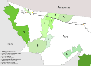
Conservation units in the west of the state of Acre, Brazil
The municipality contains 13.45% of the 846,633 hectares (2,092,080 acres) Serra do Divisor National Park, created in 1989.[3]
Population
References
- ↑ Estimativas da população residente no Brasil e unidades da federação com data de referência em 1° de julho de 2017 (PDF; 2,7 MB) (in Portuguese), IBGE: Instituto Brasileiro de Geografia e Estatística, 2017, retrieved 2018-01-21
- ↑ Cidades@ Acre: Rodrigues Alves (in Portuguese), IBGE: Instituto Brasileiro de Geografia e Estatística, retrieved 2018-01-22
- ↑ PARNA da Serra do Divisor (in Portuguese), ISA: Instituto Socioambiental, retrieved 2016-08-08
External links
This article is issued from
Wikipedia.
The text is licensed under Creative Commons - Attribution - Sharealike.
Additional terms may apply for the media files.