Manang Airport
| Manang Airport मनाङ्ग विमानस्थल | |||||||||||
|---|---|---|---|---|---|---|---|---|---|---|---|
 | |||||||||||
| Summary | |||||||||||
| Airport type | Public | ||||||||||
| Operator | Civil Aviation Authority of Nepal | ||||||||||
| Serves | Manang, Nepal | ||||||||||
| Elevation AMSL | 11,000 ft / 3,353 m | ||||||||||
| Coordinates | 28°38′28″N 84°05′17″E / 28.64112°N 84.08804°E | ||||||||||
| Map | |||||||||||
 NGX Location of airport in Nepal | |||||||||||
| Runways | |||||||||||
| |||||||||||
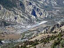
Manang Airport (IATA: NGX, ICAO: VNMA) is an airport serving Manang valley,[1] a town in the Manang district of Gandaki Province in Nepal. The airport is situated 2,5 kilometers east of Manang town.
Facilities
The airport resides at an elevation of 11,000 feet (3,353 m) above mean sea level.[1] It has one runway which is 610 metres (2,001 ft) in length. The Civil Aviation Authority of Nepal has expanded and done improvement work at Manang Airfield. It is hoped that the improvement of airport will be able to increase the frequency of air flight services to and from this airport.
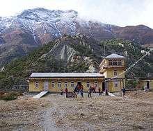
Airport terminal
Airlines and destinations
Since 2012, there are no scheduled services to and from Bajhang Airport.[3] Previously Nepal Airlines and Tara Air operated routes to Kathmandu and Pokhara.[4][5]
See also
References
- 1 2 3 Airport information for Manang, Nepal (VNMA / NGX) at Great Circle Mapper.
- ↑ "Manang Airport" (PDF). Civil Aviation Authority of Nepal. Retrieved 1 September 2018.
- ↑ "Inactive Manang Airport causes locals to face major problems". Aviation Nepal. 23 July 2015. Retrieved 1 September 2018.
- ↑ "Schedule Effective from 15 May, 2010 to 30 October, 2010". Nepal Airlines. Retrieved 9 June 2010.
- ↑ http://www.taraair.com/
External links
| International | |||||
|---|---|---|---|---|---|
| Domestic |
| ||||
| Under construction | |||||
| Defunct | |||||
Unscheduled airports may be scheduled at certain times | |||||
This article is issued from
Wikipedia.
The text is licensed under Creative Commons - Attribution - Sharealike.
Additional terms may apply for the media files.