Tanguiéta
| Tanguiéta | |
|---|---|
| Commune, arrondissement and town | |
 Entry sign for Tanguieta, Benin (coming from Natitingou), 2007 | |
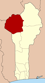
 Tanguiéta Location in Benin | |
| Coordinates: 10°37′N 1°16′E / 10.617°N 1.267°E | |
| Country |
|
| Department | Atakora Department |
| Area | |
| • Commune, arrondissement and town | 2,110 sq mi (5,465 km2) |
| Population (2002) | |
| • Commune, arrondissement and town | 54,719 |
| • Metro | 21,290 |
| Time zone | UTC+1 (WAT) |
Tanguiéta is a town, arrondissement and commune located in the Atakora Department of Benin.The commune covers an area of 5465 square kilometres and as of 2002 had a population of 54,719 people.[1][2] As of 2007 the town had an estimated population of 21,290.[3] It lies on the RNIE 3 highway which connects it to Natitingou.
Tanguiéta was the departmental seat of government during French colonial rule. The headquarters of the Pendjari National Park are based in the town, and the Hôpital Saint Jean de Dieu de Tanguiéta is a regionally recognized hospital. The town has internet access available.
The main languages spoken in the town include French, Dendi, Waama, Nateni, and Biali.
See also
References
- ↑ "Tanguieta". Atlas Monographique des Communes du Benin. Archived from the original on February 26, 2009. Retrieved January 5, 2010.
- ↑ "Communes of Benin". Statoids. Retrieved January 5, 2010.
- ↑ ""The World Gazetteer"". Archived from the original on February 9, 2013. Retrieved 2007-02-20.
Coordinates: 10°37′N 1°16′E / 10.617°N 1.267°E

This article is issued from
Wikipedia.
The text is licensed under Creative Commons - Attribution - Sharealike.
Additional terms may apply for the media files.