Atakora Department
| Atakora | |
|---|---|
| Department | |
 | |
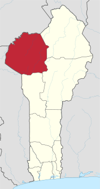 Map highlighting the Atakora Department | |
| Coordinates: 10°18′N 1°23′E / 10.300°N 1.383°ECoordinates: 10°18′N 1°23′E / 10.300°N 1.383°E | |
| Country |
|
| Capital | Natitingou |
| Area[1] | |
| • Total | 20,499 km2 (7,915 sq mi) |
| Population (2013 census) | |
| • Total | 769,337 |
| • Density | 38/km2 (97/sq mi) |
| Time zone | UTC+1 (WAT) |
Atakora is the northwestern department of Benin, bordering Togo to the west and Burkina Faso to the north. Also, it borders the departments of Alibori, Borgou, and Donga. Major towns in the Atakora include Natitingou and Tanguiéta, and the major tourist areas include the Tata Somba houses, the Pendjari National Park, and various waterfalls. The département of Atakora was bifurcated in 1999, and some of its southern territory was moved to the newly created Donga Department. The capital of the department is Natitingou.
Per 2013 census, the total population of the department was 772,262 with 380,448 males and 391,814 females. The proportion of women was 50.70 per cent. The total rural population was 62.80 percent, while the urban population was 37.20 per cent. The total labour force in the department was 170,333 out of which 27.20 per cent were women. The proportion of households with no level of education was 72.80
Geography
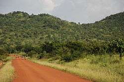
Benin is located in West Africa, bordered by Togo, Niger, Burkina Faso and Nigeria.The region is located in the northwest. The terrain is mainly forested mountains, from which two tributaries of the Niger River, Mekarou and Penjar, originate.[2] The northern regions receive one season of rainfall from May to September, while the southern regions receive two spells from March to July and September to November. Harmattan winds blow from northeast during the months of December to March. The country receives an average annual rainfall of around 1,200 mm (47 in).[3] Part of the Atakora Mountain Range is located in the region before continuing into northeastern Togo .[4] The mountain range is also characterized by dambo areas (shallow wetlands) and head swamps.[5]
Demographics
Per 2013 census, the total population of the department was 772,262 with 380,448 males and 391,814 females. The proportion of women was 50.70 per cent. The total rural population was 62.80 percent, while the urban population was 37.20 per cent. The proportion of women in child bearing age of 15 to 49 years was 21.80 per cent. The total foreign population in the department was 10,395 which formed 1.30 per cent of the total population in the department. The proportion of foreigners aged 10+ years was 33.00 per cent, while for the people aged 15–64 years, it was 32.20 per cent. The proportion of women in foreign population constituted 47.90 per cent. The number of households in the department was 107,599 and the average household size was 7.2. The intercensal growth rate of population was 3.10 per cent.[7]
The average age of women during first marriage in the department was 19.1 and the average age at maternity was 27.8. The synthetic index of fertility of women was 5.6. The average number of kernels in a house was 1.6 and the average number of persons in a room was 1.7. The total labour force in the department was 170,333 out of which 27.20 per cent were women. The proportion of households with no level of education was 72.80 and the proportion of households with children attending school was 42.70. The crude birth rate was 39.0, general rate of fertility was 179.20 and the gross reproduction rate was 2.80.[6]
Local Administration

Atakora is subdivided into nine communes, each centered at one of the principal towns, namely, Boukoumbé, Cobly, Kérou, Kouandé, Matéri, Natitingou, Pehonko, Tanguiéta and Toucountouna.[8] Benin, formerly known as Dahomey, was a French colony till 1894. It gained independence during 1960 and was admitted to the United Nations. From 1960 to 1972, there was political instability with frequent change of leadership.[9] Benin originally had six administrative divisions, but was further bifurcated to make it 12. Each deconcentrated administrative services, called directions départementales(DD) of the sectoral ministries, take care of two administrative regions. A law passed during 1999 empowered the territorial administration to local governments.[8] Municipalities and communal councils have elected representatives who manage the administration of the regions. The latest elections of the municipal and communal councils were held during June 2015.[10] The département of Atakora was bifurcated and some its southern territory were moved to the newly created Donga Department. The capital of the department is Natitingou.[8]
References
- ↑ "Benin". Geohive. Retrieved 25 November 2016.
- ↑ McColl, R. W. (2014). Encyclopedia of World Geography, Volume 1. Infobase Publishing. p. 92-93. ISBN 9780816072293.
- ↑ Haggett, Peter, ed. (2002). Encyclopedia of World Geography, Volume 17. Marshall Cavendish. p. 2325. ISBN 9780761473060.
- ↑ Idrissa, Abdourahmane; Decalo, Samuel (2012). Historical Dictionary of Niger. Scarecrow Press. p. 77. ISBN 9780810860940.
- ↑ Hughes, R. H. (1992). A Directory of African Wetlands. IUCN. ISBN 9782880329495.
- 1 2 "Socio economic data of Benin, 2013". Institut National de la Statistique et de l’Analyse Economique (INSAE) du Benin. 2013. Retrieved 25 November 2016.
- ↑ "Census of Benin, 2013". Institut National de la Statistique et de l’Analyse Economique (INSAE) du Benin. 2013. Retrieved 25 November 2016.
- 1 2 3 Republic of Benin, Public Administration and Country profile (PDF) (Report). Department of Economic and Social Affairs (DESA), United Nations. 2004. p. 8. Retrieved 17 November 2016.
- ↑ "Benin country profile". BBC. 5 August 2016. Retrieved 20 November 2016.
- ↑ "Local elections in Benin, 2015". African Elections Database. Retrieved 25 November 2016.