Natitingou
| Natitingou | |
|---|---|
| Commune and city | |
 Natitingou | |
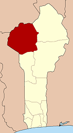
 Natitingou Location in Benin | |
| Coordinates: 10°18′N 1°22′E / 10.300°N 1.367°ECoordinates: 10°18′N 1°22′E / 10.300°N 1.367°E | |
| Country |
|
| Department | Atakora Department |
| Area | |
| • Total | 3,045 km2 (1,176 sq mi) |
| Elevation | 426 m (1,398 ft) |
| Population (2013 census)[1] | |
| • Total | 104,010 |
| • Density | 34/km2 (88/sq mi) |
| Time zone | UTC+1 (WAT) |
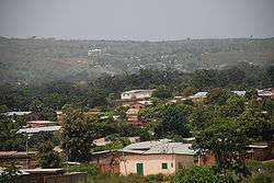
Natitingou is a city and commune in north western Benin. It is about 50 km from Benin's Pendjari National Park, where tourists can see West African wildlife during the months of December through June. The Falls of Tanougou and great mud castles of the Betammaribe known as Tata Somba are all within an hour or two of the town by car.
The commune covers an area of 3045 square kilometres and as of 2013 had a population of 104,010 people.[2][3]
History
The town was founded by the Waama ethnic groups but is populated with Ditammari, Dendi, Nateni, Fulani, Fon, and many other ethnic groups. The region takes its name from the word Nantibatingou, the Waama root "Nanto" refers to "crush" as the local people were renowned growers and processor of sorghum which was native to the area and later millet.[4]
Natitingou is evenly divided between Christians and Muslims and, like the rest of Benin, is notable for its ethnic and religious tolerance.[4]
The mountains surrounding the region to the east and west sides are important in local animist beliefs and believed to be inhabited by spirits.[4] Certain people subscribe to the idea that during the evening these spirits, emit sounds similar to those produced by stones which women uses to crush cereal grains.[4] Adherents do not crush cereals in the evening, so as not to confuse the two sounds.[4]
White missionaries visited Natitingou in the 19th century and early 20th century.[4]
Geography
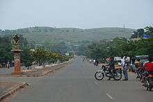
The town of Natitingou belongs to the Department of Atacora in northwestern Benin. It lies in a semi-valley, formed by the two mountain ridges that surround it. Natitingou is located 645 km from the economic capital of Cotonou and 100 km from Porga at the entrance of the Pendjari National Park.[4] The commune is bounded on the north by Toucountouna, south and east by Kouandé and to the west by the commune of Boukombé.[2][4]
The climate in Natitingou is drier than in the south, particularly during the Harmattan season in December/January, when humidity can be as low as 10% and night temperatures can be as low as 17 degrees Celsius.
Climate
| Climate data for Natitingou (1961–1990, extremes 1921–present) | |||||||||||||
|---|---|---|---|---|---|---|---|---|---|---|---|---|---|
| Month | Jan | Feb | Mar | Apr | May | Jun | Jul | Aug | Sep | Oct | Nov | Dec | Year |
| Record high °C (°F) | 40.0 (104) |
44.2 (111.6) |
42.2 (108) |
41.5 (106.7) |
40.7 (105.3) |
37.8 (100) |
39.9 (103.8) |
40.7 (105.3) |
36.4 (97.5) |
37.5 (99.5) |
39.4 (102.9) |
39.3 (102.7) |
44.2 (111.6) |
| Average high °C (°F) | 34.3 (93.7) |
36.6 (97.9) |
37.2 (99) |
35.7 (96.3) |
33.7 (92.7) |
31.4 (88.5) |
29.4 (84.9) |
29.1 (84.4) |
30.2 (86.4) |
32.5 (90.5) |
34.4 (93.9) |
34.2 (93.6) |
33.2 (91.8) |
| Daily mean °C (°F) | 26.6 (79.9) |
28.7 (83.7) |
30.0 (86) |
29.5 (85.1) |
28.1 (82.6) |
26.4 (79.5) |
25.1 (77.2) |
24.9 (76.8) |
25.3 (77.5) |
26.4 (79.5) |
26.4 (79.5) |
26.4 (79.5) |
27.0 (80.6) |
| Average low °C (°F) | 19.0 (66.2) |
20.8 (69.4) |
22.8 (73) |
23.3 (73.9) |
22.5 (72.5) |
21.4 (70.5) |
20.8 (69.4) |
20.8 (69.4) |
20.4 (68.7) |
20.2 (68.4) |
18.5 (65.3) |
18.5 (65.3) |
20.7 (69.3) |
| Record low °C (°F) | 11.3 (52.3) |
13.4 (56.1) |
15.8 (60.4) |
17.8 (64) |
17.8 (64) |
17.8 (64) |
18.0 (64.4) |
18.0 (64.4) |
17.7 (63.9) |
15.8 (60.4) |
11.4 (52.5) |
8.8 (47.8) |
8.8 (47.8) |
| Average precipitation mm (inches) | 0.9 (0.035) |
2.2 (0.087) |
26.7 (1.051) |
89.3 (3.516) |
108.2 (4.26) |
139.9 (5.508) |
225.5 (8.878) |
263.6 (10.378) |
254.7 (10.028) |
107.1 (4.217) |
9.0 (0.354) |
3.7 (0.146) |
1,230.8 (48.457) |
| Average precipitation days (≥ 1.0 mm) | 0 | 0 | 3 | 6 | 9 | 11 | 14 | 18 | 18 | 9 | 1 | 0 | 89 |
| Average relative humidity (%) | 27 | 28 | 41 | 60 | 72 | 79 | 82 | 86 | 84 | 76 | 52 | 33 | 60 |
| Mean monthly sunshine hours | 272.8 | 249.2 | 248.0 | 240.0 | 244.9 | 207.0 | 164.3 | 139.5 | 162.0 | 226.3 | 264.0 | 260.4 | 2,678.4 |
| Source #1: NOAA[5] | |||||||||||||
| Source #2: Deutscher Wetterdienst (humidity, 1961–1990),[6] Meteo Climat (record highs and lows)[7] | |||||||||||||
Administrative divisions
Natitingou is subdivided into nine arrondissements; four of them urban: Natitingou I, Natitingou II, Natitingou III and Natitingou IV (Péporiyakou) and five of them rural:Kotapounga, Kouaba, Koundata, Perma and Tchoumi-Tchoumi. They contain 39 villages and 26 urban districts.[2]
Demographics
The commune has a population of 75,620 inhabitants according to the 2002 census (57,153 in 1992) with 37,388 men and 38,223 women.[4] The density is 56 inhabitants per km². The population is predominantly young.[4]
A multitude of ethnic people of the commune exists with a variety of languages. The main ethnic groups are the Ditammari, Waama and Dendi.[4] Outside the animist religion, Christianity and Islam are practiced religions and there are a number of churches and mosques in the area. However, many Christians and Muslims often simultaneously believe in animist practices and join in traditional events in Natitingou.
Economy
People in the urban districts of Natitingou are mostly civil servants, craftsmen and merchants.[4] Natitingou has an important administrative function and has some of the most important administrative bodies and services in the Atakora Department.[4]
Agriculture is the backbone to the rural economy, and farmers produce sorghum, maize, yams and, more recently, cotton as a commercial product.[4] The manufacture and marketing of the local drink known as Tchoucoutou is also very important, and is produced by housewives and is their main source of income.[4] The drink is sold to nightclubs where there are many consumers. Tchoucoutou is made from the grain sorghum and is a form of malt beer.[4]
Notable people
Villanova University Men's Basketball player Mouphtau Yarou is a native of Natitingou.[8] He was ranked #9 in 2009 among high school basketball prospects in America.
Charles Thiebaut, a promoter of African music and culture in France, is a native of Natitingou. He grew up in an orphanage and was adopted by the Thiebaut family from France, when he was 4 years old.
References
- ↑ "World Gazetteer". Archived from the original on January 11, 2013.
- 1 2 3 "Natitingou". Atlas Monographique des Communes du Benin. Archived from the original on February 26, 2009. Retrieved January 5, 2010.
- ↑ "Communes of Benin". Statoids. Archived from the original on April 30, 2012. Retrieved January 5, 2010.
- 1 2 3 4 5 6 7 8 9 10 11 12 13 14 15 16 "Commune de Natitingou" (in French). Natitingou.org. Retrieved January 18, 2010.
- ↑ "Natitingou Climate Normals 1961–1990". National Oceanic and Atmospheric Administration. Retrieved 13 January 2015.
- ↑ "Klimatafel von Natitingou, Prov. Atakora (Nw) / Benin" (PDF). Baseline climate means (1961-1990) from stations all over the world (in German). Deutscher Wetterdienst. Retrieved 11 June 2016.
- ↑ "Station Natitingou" (in French). Meteo Climat. Retrieved 11 June 2016.
- ↑ "Mouphtaou Yarou Bio - Villanova University Official Athletic Site". Villanova.com. Retrieved 2014-07-17.
External links