Tamghas
| Tamghās तम्घास | |
|---|---|
| City | |
 Tamghas | |
 Tamghās Location in Nepal | |
| Coordinates: 28°4′N 83°15′E / 28.067°N 83.250°ECoordinates: 28°4′N 83°15′E / 28.067°N 83.250°E | |
| Country |
|
| Admin. division | Lumbini Zone |
| District | Gulmi District |
| Population (2001) | |
| • Total | 10,680 |
| Climate | Cwb |
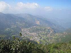
Tamghas, also Gulmi Tamghas or Tamghas Bazaar (Nepali: तम्घास) is the centre of Resunga Municipality, and the district headquarter of Gulmi district. It is located at 28°4'0N 83°15'0E with an altitude of 1838 metres (6033 feet). As of 2001 it had a population of 10, 680. [1][2]There are significant cobalt reserves in the area.[3][4]In the 1970s a road was planned between Tamghas and Palpa District.[5]The village of Arkhale is located just to the northwest.Major religious places located here is Resunga hill.
Notable landmarks
Tamghas contains the main educational institutions in Gulmi District including Adarsha Bidhya Ashram, Arjun Boarding High School, Brilliant United Academy, Gandaki Boarding School, Vujelkharka School, Siddababa Higher Secondary School, Donbosco School, Buddha Lower Secondary School, Resunga Higher Secondary School, Mahendra Higher Secondary School and Reader's Public High School.[6] The district government offices [7]and the police headquarters is located in the town and the Nepalese Army also have a base here.[6] The town is served by Tamghas Hospital, located just south of Tamghas Jail.[6]Notable places of worship in Tamghas are Shivalaya, Bhagawati Mandir, Tamghas Vagawati Mandir and Siddhababa Mandir.[6]. In the Arjun hill we can see cave and it is also a religious place.
Media
To Promote local culture Tamghas has two FM radio stations Radio Sky - 88.4 MHz and Radio Resunga 106.2 MHz, Which are Community radio Stations.
References
- ↑ National Report 2001 Archived 2009-03-27 at the Wayback Machine., Central Bureau of Statistics - Government of Nepal
- ↑ Gautam, Ram Prasad (2008). Development profile of Nepal 2008. Informal Sector Research and Study Center. ISBN 978-99946-944-1-9. Retrieved 31 July 2011.
- ↑ Natural resources of Nepal. S. Sharma. 1978. Retrieved 31 July 2011.
- ↑ Geological Survey of India (1962). Records of the Geological Survey of India. The Survey. Retrieved 31 July 2011.
- ↑ Nepal press digest. Regmi Research Project. 1975. Retrieved 31 July 2011.
- 1 2 3 4 Maps (Map). Google Maps.
|access-date=requires|url=(help) - ↑ Rai, Kavitā (10 August 2005). Dam development: the dynamics of social inequality in a hydro power project in Nepal. Cuvillier Verlag. p. 68. ISBN 978-3-86537-576-6. Retrieved 31 July 2011.