Tama, Tokyo
| Tama 多摩市 | |||
|---|---|---|---|
| City | |||
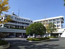 Tama City Hall | |||
| |||
 Location of Tama in Tokyo | |||
 Tama | |||
| Coordinates: 35°38′13″N 139°26′46.6″E / 35.63694°N 139.446278°ECoordinates: 35°38′13″N 139°26′46.6″E / 35.63694°N 139.446278°E | |||
| Country | Japan | ||
| Region | Kantō | ||
| Prefecture | Tokyo | ||
| Area | |||
| • Total | 21.01 km2 (8.11 sq mi) | ||
| Population (February 2016) | |||
| • Total | 147,953 | ||
| • Density | 7,040/km2 (18,200/sq mi) | ||
| Time zone | UTC+9 (Japan Standard Time) | ||
| Symbols | |||
| • Tree | [Ginkgo biloba]] | ||
| • Flower | Prunus serrulata | ||
| • Bird | Oriental turtle dove | ||
| Phone number | 042-375-8111 | ||
| Address | 6-12-1 Sekido, Tama-shi, Tokyo 206-8666 | ||
| Website |
www | ||


Tama (多摩市 Tama-shi) is a city located in the western portion of Tokyo Metropolis, Japan. As of 1 February 2016, the city had an estimated population of 147,953, and a population density of 7040 persons per km². Its total area is 21.01 square kilometres (8.11 sq mi).
Geography
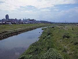
Tama is located in the foothills of the Okutama Mountains of southwestern Tokyo, known as Tama Hills, which spans Tokyo and Kanagawa Prefecture. The entire region is historically referred to as Tama; therefore there are many place names scattered throughout the area with references to the name "Tama" which are not within the city limits. The Tama River marks the city's northern boundary, and Kanagawa Prefecture is to the south. Its southern half forms part of the Tama New Town project, Japan's largest residential development, constructed in the 1970s.
Surrounding municipalities
History
The area of present-day Tama was part of ancient Musashi Province. In the post-Meiji Restoration cadastral reform of July 22, 1878, the area became part of Minamitama District in Kanagawa Prefecture. The village of Tama was created on April 1, 1889 with the establishment of municipalities law. Minamitama District was transferred to the administrative control of Tokyo Metropolis on April 1, 1893. Tama was elevated to town status on April 1, 1964. Construction of Tama New Town began in 1966, and the first occupants started moving in 1971. On November 1, 1971, Tama Town was reclassified as Tama City, dissolving Minamitama District. Tama was the last town in the former Minamitama District
Economy
Several companies have their headquarters in the city:
Education
Universities and colleges
- Keisen University Tama Campus
- Kokushikan University Tama Campus
- Otsuma Women's University Tama Campus
- Tama University Tama Campus
- Teikyo University Hachioji Campus
- University of Tokyo Health Sciences
- National Farmer's Academy
Elementary and secondary schools
- The Tama city government operates 18 public elementary and nine public middle schools. There is also one private elementary school and one private middle school.
- The Tokyo Metropolitan Government Board of Education operates Nagayama High School,[3] the one public high school. There are also three private combined middle/high schools.
Transportation
Railway
Highway
Tama is not served by any national expressways or national highways
Military facilities
- Tama Hills, a recreational facility of the U.S. Air Force, intended for use by United States service members and their families, as well as Japan Maritime Self-Defense Force service members and their families.
Local attractions
- Sanrio Puroland Amusement Park
- Thirteen Buddhas of Tama
Sister cities

References
- ↑ "Company Information." Mitsumi Electric Retrieved on June 16, 2015.
- ↑ "Corporate Outline." JUKI Retrieved on August 4, 2015.
- ↑
External links
| Wikimedia Commons has media related to Tama, Tokyo. |
| Wikivoyage has a travel guide for Tama. |
- Tama City Official Website (in Japanese)
| Special Wards of Tokyo | |||||||
|---|---|---|---|---|---|---|---|
| Western (Tama area) |
| ||||||
| Subprefectures | |||||||
| |||||||