Hamura, Tokyo
| Hamura 羽村市 | |||
|---|---|---|---|
| City | |||
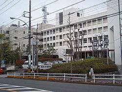 Hamura City Hall | |||
| |||
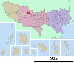 Location of Hamura in Tokyo Metropolis | |||
 Hamura | |||
| Coordinates: 35°46′1.8″N 139°18′39.4″E / 35.767167°N 139.310944°ECoordinates: 35°46′1.8″N 139°18′39.4″E / 35.767167°N 139.310944°E | |||
| Country | Japan | ||
| Region | Kantō | ||
| Prefecture | Tokyo Metropolis | ||
| Area | |||
| • Total | 9.90 km2 (3.82 sq mi) | ||
| Population (February 2016) | |||
| • Total | 55,596 | ||
| • Density | 5,620/km2 (14,600/sq mi) | ||
| Time zone | UTC+9 (Japan Standard Time) | ||
| City symbols | |||
| • Tree | Ginkgo | ||
| • Flower | Sakura | ||
| • Bird | Brown hawk owl | ||
| Phone number | 042-555-1111 | ||
| Address | 5-2-1 Midorigaoka, Hamura-shi, Tokyo-to 205-8601 | ||
| Website |
www | ||


Hamura (羽村市 Hamura-shi) is a city located in the western portion of Tokyo Metropolis, Japan. As of 1 February 2016, the city had an estimated population of 55,596, and a population density of 5620 persons per km². Its total area is 9.90 square kilometres (3.82 sq mi).
The J-Pop singing duet Cazacy calls Hamura home.
Geography
Hamura is approximately in the west-center of Tokyo Metropolis, on the Musashino Terrace. It flanks the Tama River about 50 kilometres (31 mi) upriver from the mouth.
Hamura is composed of the following neighborhoods: Fujimadaira, Futabacho, Gonokami, Hane, Hanehigashi, Kawasaki, Midorigaoka, Ozakudai, Shinmeidai, Tamagawa, Yokotakichinai. These neighborhoods in Japanese administrative structure are units known as chos.
Surrounding municipalities
History
The area of present-day Hamura has been inhabited since Japanese Paleolithic times, and numerous remains from the Jōmon, Yayoi and Kofun periods have been discovered. During the Nara period, it became part of ancient Musashi Province. The Tamagawa Josui, an artificial waterway completed in 1653 to divert water from the Tama River and carry it as drinking water to Edo, begins in what is now part of Hamura.
In the post-Meiji Restoration cadastral reform of April 1, 1889, several villages (one of which was named Hane-mura) merged to form Nishitama Village in Nishitama District, at that time part of Kanagawa Prefecture. The entire district was transferred to the control of Tokyo Prefecture on April 1, 1893. In 1956, Nishitama Village became the town of Hamura. On November 1, 1991, Hamura was elevated to city status.
Economy
Hamura is primary a regional commercial center, and a bedroom community for central Tokyo and neighbouring Ōme. Several electronic companies have light industrial or logistical facilities in Hamura. Hino Motors and Toyota have a plant and test track in the city.
Education
Hamura has seven public elementary schools and three public middle schools. The city also has one high school operated by the Tokyo Metropolitan Government Board of Education [1] and one special education school.
Transportation
Railway
Highway
Sister city relations
Hamura has been twinned with Hokuto, Yamanashi in Japan since October 1, 1996.
Local attractions
- Hamura Diversion Weir
- Aso Shrine
- Hamura Zoo
Notable people from Hamura
- Shinji Jojo - professional soccer player
- Yuzo Kobayashi – professional soccer player
- Shizuka Kudo – actress, singer
- Hiroomi Tosaka - singer and actor
References
- ↑ 東京都立羽村高等学校(in Japanese)
External links
| Wikimedia Commons has media related to Hamura, Tokyo. |
- Hamura City Official Website (in Japanese)
| Special Wards of Tokyo | |||||||
|---|---|---|---|---|---|---|---|
| Western (Tama area) |
| ||||||
| Subprefectures | |||||||
| |||||||