Tayibe (Lebanon)
| Tayibe (طيبة (مرجعيون | |
|---|---|
| Village | |
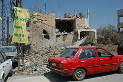 Posters on Tayibe village walls after the 2006 Lebanon War | |
 Tayibe Location within Lebanon | |
| Coordinates: 33°16′35″N 35°31′14″E / 33.27639°N 35.52056°ECoordinates: 33°16′35″N 35°31′14″E / 33.27639°N 35.52056°E | |
| Grid position | 198/297 PAL |
| Country |
|
| Governorate | Nabatieh Governorate |
| District | Marjeyoun District |
| Elevation | 660 m (2,170 ft) |
| Time zone | UTC+2 (EET) |
| • Summer (DST) | UTC+3 (EEST) |
| Dialing code | +961 |
| Et Taibeh | |
| Alternative name | Et Tayibe |
|---|---|
| Location | 2 kilometres (1.2 mi) south of the Litani River |
| History | |
| Periods | Heavy Neolithic |
| Cultures | Qaraoun culture |
| Site notes | |
| Archaeologists | Louis Dubertret and Jacques Cauvin |
| Public access | Unknown |
Tayibe, Et Tayibe or Et Taibeh is a village in the Marjeyoun District in south Lebanon.
Name
According to E. H. Palmer, the name Tayibe means "The good, sweet, or wholesome" (about water).[1]
Archaeological site
By the village is a Heavy Neolithic archaeological site of the Qaraoun culture.[2][3]
The site was discovered by Louis Dubertret and materials studied by Jacques Cauvin. Heavy Neolithic materials recovered resembled those from Qaraoun.[3]
History
In 1875, Victor Guérin found here a village with 800 Metualis.[4] He further noted: "Its principal mosque, now in ruins, is built of superb blocks, apparently ancient. It contains in the interior several monolithic columns."[5]
In 1881, the Palestine Exploration Fund's Survey of Western Palestine (SWP) noted here: "There are several sarcophagi and cisterns in the village ; some caves near."[6] They further described it as: "A large well-built village, built of stone, containing about 600 Metawileh and 400 Moslems. The Caimacam has a good house here. There are some figs and olives round the village and arable land; water is supplied from a spring and two birkets."[7]
Modern era
On August 5, during the 2006 Lebanon War, Israeli war-planes killed 3 civilians, aged 2 to 48 years of age. The IDF offered no explanations to the strike.[8]
References
- ↑ Palmer, 1881, p. 33
- ↑ Moore, A.M.T. (1978). The Neolithic of the Levant. Oxford University, Unpublished Ph.D. Thesis. pp. 444–446.
- 1 2 L. Copeland; P. Wescombe (1966). Inventory of Stone-Age Sites in Lebanon: North, South and East-Central Lebanon, p. 53. Impr. Catholique. Retrieved 29 August 2011.
- ↑ Guérin, 1880, pp. 268-269
- ↑ Guérin, 1880, pp. 268-269; as given in Conder and Kitchener, 1881, SWP I, p. 139
- ↑ Conder and Kitchener, 1881, SWP I, p. 139
- ↑ Conder and Kitchener, 1881, SWP I, p. 90
- ↑ HRW, 2007, p. 131
See also
Bibliography
- Conder, C.R.; Kitchener, H.H. (1881). The Survey of Western Palestine: Memoirs of the Topography, Orography, Hydrography, and Archaeology. 1. London: Committee of the Palestine Exploration Fund.
- Guérin, V. (1880). Description Géographique Historique et Archéologique de la Palestine (in French). 3: Galilee, pt. 2. Paris: L'Imprimerie Nationale.
- HRW (2007). Why They Died: Civilian Casualties in Lebanon During the 2006 War. Human Rights Watch.
- Palmer, E.H. (1881). The Survey of Western Palestine: Arabic and English Name Lists Collected During the Survey by Lieutenants Conder and Kitchener, R. E. Transliterated and Explained by E.H. Palmer. Committee of the Palestine Exploration Fund.
External links
- Taybeh (Marjaayoun), Localiban
- Survey of Western Palestine, Map 2: IAA, Wikimedia commons
| Capital | 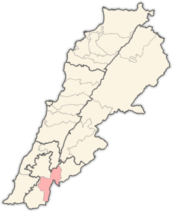 | |
|---|---|---|
| Towns and villages | ||
| Other | ||