Ibl al-Saqi
| Ebel El Saqi إبل السقي | |
|---|---|
| Town | |
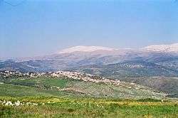 Ibl al-Saqi in 1997 | |
 Ebel El Saqi Location within Lebanon | |
| Coordinates: 33°21′26.18″N 35°37′39.17″E / 33.3572722°N 35.6275472°ECoordinates: 33°21′26.18″N 35°37′39.17″E / 33.3572722°N 35.6275472°E | |
| Grid position | 139/157 L |
| Country |
|
| Governorate | Nabatieh Governorate |
| District | Marjeyoun District |
| Elevation | 760 m (2,490 ft) |
| Time zone | UTC+2 (EET) |
| • Summer (DST) | UTC+3 (EEST) |
| Dialing code | +961 |
Ibl al-Saqi (إبل السقي) is a town in the Marjeyoun District in southern Lebanon.
History
In 1875, Victor Guérin found it to be a "considerable" village, with about 1000 inhabitants. 700 were "Schismatic Greek" and the rest were apparently Druze. At the north-west of the village there was an abundant stream.[1]
Sister cities
References
Bibliography
- Guérin, Victor (1880). Description Géographique Historique et Archéologique de la Palestine (in French). 3: Galilee, pt. 2. Paris: L'Imprimerie Nationale.
External links
- Ibl Es Saqi, Localiban
| Capital | 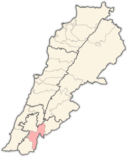 | |
|---|---|---|
| Towns and villages | ||
| Other | ||
This article is issued from
Wikipedia.
The text is licensed under Creative Commons - Attribution - Sharealike.
Additional terms may apply for the media files.