Hula, Lebanon
| Hula حولا | |
|---|---|
| Village | |
 | |
 Hula Location within Lebanon | |
| Coordinates: 33°13′N 35°31′E / 33.217°N 35.517°ECoordinates: 33°13′N 35°31′E / 33.217°N 35.517°E | |
| Grid position | 198/290 PAL |
| Country |
|
| Governorate | Nabatieh Governorate |
| District | Marjeyoun District |
| Elevation | 750 m (2,460 ft) |
| Time zone | UTC+2 (EET) |
| • Summer (DST) | UTC+3 (EEST) |
| Dialing code | +961 |
| Website | http://houla.net |
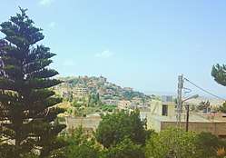
Hula (Hule, Houla, Arabic: حولا)[1] is a small Muslim village in southern Lebanon on the southern side of the Litani river near the Lebanese-Palestinian border. The largest family known there, the family of Yassine ياسين (aile Yasin), traces its lineage as direct descendent of the Islamic prophet, Muhammad.[2] It is located 750 meters above the sea-level.
During the 1948 Arab-Israeli war two officers from the IDF carried out the Hula massacre in the village, killing over 80 civilians of ages 15-60.[3]
History
In 1881, the Palestine Exploration Fund's Survey of Western Palestine (SWP) described it as: A village, built of stone, containing about 500 Shia, one of the most prominent objects in which is a Sheikh's tomb. It is situated on the hill-top, and is surrounded by olives, vines, and arable land. There are several cisterns, two birkets (one rock-cut), and a spring.[4]
Modern era
During the 2006 Israel-Lebanon conflict, on July 15, Israel killed 2 young women in an air-strike against a home in Hula.[5]
On August 7, 2006, an Israeli airstrike on Houla killed another civilian.[6][7]
The first Lebanese businessman (Abdel-Karim Yassine عبد الكريم ياسين) to start a business in Kuwait was from Hula, Lebanon.[8]
References
- ↑ Meaning: "properly dark green herbage", according to Palmer, 1881, p. 21
- ↑ "محمد", ويكيبيديا، الموسوعة الحرة (in Arabic), 2018-06-11, retrieved 2018-06-22
- ↑ Journal of Palestine Studies, vol. VII, no. 4 (summer 1978), no. 28, pp. 143-145
- ↑ Conder and Kitchener, 1881, SWP I, p. 87
- ↑ HRW, 2007, p. 91
- ↑ HRW, 2007, p. 136
- ↑ Booth, Jenny; agencies (August 7, 2006). "Israel threatens to widen offensive in Lebanon". The Times.
- ↑ "تاريخ الكويت". www.kuwait-history.net (in Arabic). Retrieved 2017-12-28.
Bibliography
- Conder, C.R.; Kitchener, H.H. (1881). The Survey of Western Palestine: Memoirs of the Topography, Orography, Hydrography, and Archaeology. 1. London: Committee of the Palestine Exploration Fund.
- Guérin, V. (1880). Description Géographique Historique et Archéologique de la Palestine (in French). 3: Galilee, pt. 2. Paris: L'Imprimerie Nationale.
- HRW (2007). Why They Died: Civilian Casualties in Lebanon During the 2006 War. Human Rights Watch.
- Palmer, E.H. (1881). The Survey of Western Palestine: Arabic and English Name Lists Collected During the Survey by Lieutenants Conder and Kitchener, R. E. Transliterated and Explained by E.H. Palmer. Committee of the Palestine Exploration Fund.
External links
- Survey of Western Palestine, Map 2: IAA, Wikimedia commons
- Houla, Localiban
| Capital | 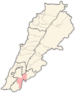 | |
|---|---|---|
| Towns and villages | ||
| Other | ||