Table Rock Lake
| Table Rock Lake | |
|---|---|
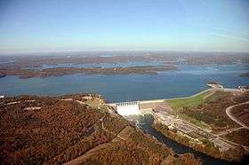 An aerial photo of Table Rock Dam completed in 1958, in Branson, Missouri, which impounds the White River and forms Table Rock Lake | |
 Table Rock Lake  Table Rock Lake | |
| Location | Missouri / Arkansas |
| Coordinates | 36°34′00″N 93°18′0″W / 36.56667°N 93.30000°WCoordinates: 36°34′00″N 93°18′0″W / 36.56667°N 93.30000°W |
| Type | reservoir |
| Primary inflows | White River, James River, Kings River |
| Primary outflows | White River |
| Basin countries | United States |
| Surface area | 43,100 acres (174 km2) |
| Max. depth | 220 ft (67 m) |
| Water volume | 3,462,000 acre⋅ft (4.270 km3) |
| Shore length1 |
Flood Pool: 857 mi (1,379 km) Normal Pool: 745 mi (1,199 km) |
| Surface elevation | 915 ft (279 m) |
| Settlements | Branson, Missouri • Shell Knob, Missouri • Cape Fair, Missouri • Hollister, Missouri |
| 1 Shore length is not a well-defined measure. | |
Table Rock Lake is an artificial lake or reservoir in the Ozarks of southwestern Missouri and northwestern Arkansas. The lake is impounded by Table Rock Dam (located 36°35′43″N 93°18′40″W / 36.595374°N 93.311137°W) constructed from 1954 to 1958 on the White River by the U.S. Army Corps of Engineers.[1]
It is a popular attraction for the nearby town of Branson, Missouri. There are several commercial marinas along the lake, and Table Rock State Park is located on the east side, both north and south of Table Rock Dam. Downstream from the dam, the Missouri Department of Conservation operates a fish hatchery, which is used to stock trout in Lake Taneycomo. The cold water discharged from the dam creates a trout fishing environment in the lake.
The lake derives its name from a rock formation resembling a table at the small community of Table Rock, Missouri on Highway 165 about a mile and a half downstream from where the dam was built.[2]
Lake temperature
The lake area temperature varies according to season:[3]
- Spring: 56 to 77 °F (25 °C)
- Summer: 85 to 90 °F (32 °C)
- Fall: 71 to 82 °F (28 °C)
- Winter: 42 to 47 °F (8 °C)
Lake data
Dam and Outlet Measurements[4]
- Length of dam: 6,423 feet (1,958 m)
- Length of concrete section: 1,602 feet (488 m)
- Maximum height of dam above stream bed: 252 feet (77 m)
- Concrete in dam: 1,230,000 cubic yards (940,000 m3)
- Earth in embankment: 3,320,000 cubic yards (2,540,000 m3)
- Length of spillway: 531 gross feet
- Spillway crest gates size: 45x37 feet
- Outlet conduits size: 4x9 feet
Dam elevations above mean sea level[4]
- Top of dam: 947 feet (289 m)
- Spillway crest: 896 feet (273 m)
Lake elevations above mean sea level[4]
- Top of flood control pool: 931 feet (284 m)
- Top of normal pool: 915 feet (279 m)
Surface area of lake[4]
- Flood control pool: 52,300 acres (212 km2)
- Normal pool: 43,100 acres (174 km2)
Maximum storage capacity[4]
- Flood control pool: 760,000 acre feet (940,000,000 m3)
Shoreline length[4]
- Flood control pool: 857 miles (1,379 km)
- Normal pool: 745 miles (1,199 km)
Other[4]
- Power drawdown and dead: 2,702,000
- Lake total: 3,462,000
Power generating data[4]
- Number of generating units: 4
- Rated capacity for each unit: 50 megawatts
- Station installed capacity: 200 megawatts
Flood control
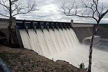
The original purpose of the reservoir was for flood control on the White River. The dam had been authorized a month earlier under the Flood Control Act of September 3, 1943. The reservoir has a fluctuation of 16 feet (4.9 m). When the reservoir is above the maximum flood pool, excess water goes over the auxiliary overflow spillway at the north end of the dam.
The worst-case scenario of a catastrophic floodwater discharge from Table Rock Lake using the auxiliary floodgates would roughly resemble this:
At elevation 931 Table Rock Lake is at full flood capacity. The ten Tainter gates are opened to accommodate additional lake inflow from the White River Basin including the James River and Beaver Lake discharge.
At elevation 937 Table Rock Lake is 6 feet above flood capacity. The ten Tainter gates are opened wider in an effort to stabilize reservoir rise. Outflow from the Lake under these circumstances will be nearing 200-300 thousand cubic feet per second (CFS).
At elevation 942 Table Rock Lake is 11 feet above flood capacity and at its "design pool", or the maximum elevation that the reservoir is engineered to reach, under "probable maximum flood" scenarios. The dam’s ten Tainter gates will be fully raised to their maximum height of approximately 30 feet letting loose 550 thousand CFS into Lake Taneycomo. This scenario would effectively submerge and destroy the powerhouse, power transmission grid, hatchery, and wreak serious destruction down stream. An illustration of how Table Rock’s ten spillways might appear under these circumstances mimics this: the floodgates will extend up and out from the structure, like eyebrows, shadowing the concrete spillways!
At elevation 947 Table Rock Dam would be at its maximum capacity and water would be at the very top of the dam. The auxiliary spillway would be brought online, in concert with Table Rock’s fully opened floodgates. This catastrophic or "last resort" protocol releases 1 million CFS of lake waters into Taneycomo and deals dreadful destruction to Branson, Hollister, Point Lookout and possibly the Powersite Dam. At this point there is a danger of water overtopping the concrete dam and breaching the earthen structure, which imminently leads to cataclysmic structural failure and the uncontrolled release of the Table Rock Lake impoundment—nearly 3 million CFS of water.
Table Rock Lake has a record crest of 935.47 feet, which occurred on April 27, 2011.
In December 2015, the dam released 72,000 CFS at its peak. This is the highest amount ever released.[5]
Facilities and State Park
Table Rock State Park provides public access to the lake. Six miles from Branson and located just south of the dam and outlet, facilities include a boat launch and full service marina (including cafe, boat rental and scuba dive shop), campground (including full RV hookups and a yurt), fishing access, swimming access (no beach), picnic area, amphitheater, hiking and mountain bike trails, and dump station.[6]
Area71 is a recreational vehicle (RV) resort, restaurant, and general store on Table Rock Lake in Shell Knob, Missouri. The store and restaurant were completely rebuilt in 2016 with an expanded menu and bait shop. The RV park features views of Table Rock Lake with long term site rental agreements.
2018 Boating Accident
Seventeen people were killed on July 19, 2018 when a duck boat filled with tourists capsized and sank in high winds on Table Rock Lake.[7]
References
- ↑ "Little Rock District > Missions > Recreation > Lakes > Table Rock Lake > Dam and Lake Information". U.S. Army Corps of Engineers. Retrieved July 20, 2018.
- ↑ https://www.houseboating.org/The-Unparalleled-Appeal-of-Table-Rock-Lake-Missouri-Blog
- ↑ "Branson". Branson. Retrieved July 20, 2018.
- 1 2 3 4 5 6 7 8 "Archived copy". Archived from the original on June 26, 2004. Retrieved June 26, 2004. Army Corps of Engineers
- ↑ Little Rock District Corps of Engineers
- ↑ "Table Rock State Park". Missouri State Parks. Missouri Department of Natural Resources. Retrieved December 27, 2016.
- ↑ Hanna, Jason; Stapleton, Anne-Claire; Karimi, Faith; Baldacci, Marlena (July 20, 2018). "17 killed in Missouri duck boat sinking ranged in age from 1 to 70". CNN. Retrieved July 20, 2018.
Further reading
| Wikimedia Commons has media related to Table Rock Lake. |
- "Wake Up to Table Rock Lake", pamphlet available at the Table Rock Dam Visitors' Center