Tōgō, Aichi
| Tōgō 東郷町 | |||
|---|---|---|---|
| Town | |||
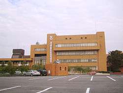 Tōgō Town Office | |||
| |||
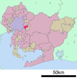 Location of Tōgō in Aichi Prefecture | |||
 Tōgō | |||
| Coordinates: 35°05′47.9″N 137°03′9.1″E / 35.096639°N 137.052528°ECoordinates: 35°05′47.9″N 137°03′9.1″E / 35.096639°N 137.052528°E | |||
| Country | Japan | ||
| Region |
Chūbu region Tōkai region | ||
| Prefecture | Aichi Prefecture | ||
| District | Aichi | ||
| Area | |||
| • Total | 18.03 km2 (6.96 sq mi) | ||
| Population (May 2015) | |||
| • Total | 42,695 | ||
| • Density | 2,370/km2 (6,100/sq mi) | ||
| Time zone | UTC+9 (Japan Standard Time) | ||
| - Tree | Ternstroemia | ||
| - Flower | Siberian iris | ||
| Phone number | 0561-38-3111 | ||
| Address | Tōgō-chō, Aichi-gun, Aichi-ken 470-0198 | ||
| Website | Official website | ||


Tōgō (東郷町 Tōgō-chō) is a town located in Aichi District, Aichi Prefecture, Japan.
As of May 2015, the town had an estimated population of 42,695 and a population density of 2370 persons per km². The total area was 18.03 square kilometres (6.96 sq mi).
Geography
Tōgō is located in the flatlands of central Aichi Prefecture.
Neighboring municipalities
History
Tōgō Village was established in 1878 through the merger of several small hamlets. It was elevated to town status on April 1, 1970.
Education
- Tōgō has six elementary schools, three middle schools and two high schools.
Transportation
Railway
Tōgō currently has no passenger train station within town limits.
Highway
Local attractions

Yukufu-ji temple
- Kurozasa Nana-go-Kama Kiln
- Yukufu-ji temple
External links
![]()
- Official website (in Japanese)
| Wards of Nagoya | ||
|---|---|---|
| Core cities | ||
| Special cities | ||
| Cities | ||
| Districts | ||
| Law Enforcement | ||
This article is issued from
Wikipedia.
The text is licensed under Creative Commons - Attribution - Sharealike.
Additional terms may apply for the media files.