Nakagawa-ku, Nagoya
| Nakagawa 中川区 | |
|---|---|
| Ward | |
| Nakagawa Ward | |
 Matsushige Rock Gate | |
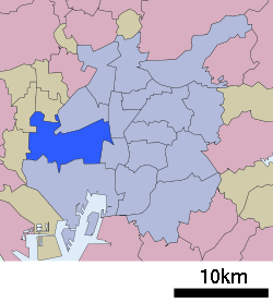 Location of Nakagawa in Aichi Prefecture | |
 Nakagawa Location in Japan | |
| Coordinates: 35°8′30″N 136°51′18″E / 35.14167°N 136.85500°ECoordinates: 35°8′30″N 136°51′18″E / 35.14167°N 136.85500°E | |
| Country | Japan |
| Region |
Chūbu region Tōkai region |
| Prefecture | Aichi Prefecture |
| Area | |
| • Total | 32.03 km2 (12.37 sq mi) |
| Population (September 2011[1]) | |
| • Total | 221,751 |
| • Density | 6,909/km2 (17,890/sq mi) |
| Symbols | |
| • Tree | Japanese Black Pine |
| • Flower | Ornamental cabbage[2] |
| Time zone | UTC+9 (JST) |
| City hall address |
愛知県名古屋市中川区高畑一丁目223 454-8501 |
| Website |
www |
Nakagawa (中川区 nakagawaku) is one of the 16 wards of the city of Nagoya in Aichi Prefecture, Japan.
| Wikimedia Commons has media related to Nakagawa-ku, Nagoya. |
References
- ↑ 平成23年9月1日現在の世帯数と人口(全市・区別) (in Japanese). Nagoya City. 20 September 2011.
- ↑ 中川区の紹介 (in Japanese). Nagoya City. 1 October 2007.
| Wards of Nagoya | ||
|---|---|---|
| Core cities | ||
| Special cities | ||
| Cities | ||
| Districts | ||
| Law Enforcement | ||
This article is issued from
Wikipedia.
The text is licensed under Creative Commons - Attribution - Sharealike.
Additional terms may apply for the media files.