Szikszó District
| Szikszó District Szikszói járás | ||
|---|---|---|
| Districts of Hungary | ||
| ||
 Szikszó District within Hungary and Borsod-Abaúj-Zemplén County. | ||
| Country |
| |
| County | Borsod-Abaúj-Zemplén | |
| District seat | Szikszó | |
| Area | ||
| • Total | 309.25 km2 (119.40 sq mi) | |
| Area rank | 14th in Borsod-Abaúj-Zemplén | |
| Population (2011 census) | ||
| • Total | 17,507 | |
| • Rank | 13th in Borsod-Abaúj-Zemplén | |
| • Density | 57/km2 (150/sq mi) | |

Szikszó (Hungarian: Szikszói járás) is a district in central-northern part of Borsod-Abaúj-Zemplén County. Szikszó is also the name of the town where the district seat is found. The district is located in the Northern Hungary Statistical Region.
Geography
Szikszó District borders with Encs District northeast, Szerencs District to the southeast, Miskolc District to the southwest, Edelény District to the west. The number of the inhabited places in Szikszó District is 24.
Municipalities
The district has 1 town and 23 villages. (ordered by population, as of 1 January 2012)[1]
- Abaújlak (131)
- Abaújszolnok (191)
- Alsóvadász (1,562)
- Aszaló (1,879)
- Felsővadász (543)
- Gadna (262)
- Gagybátor (226)
- Gagyvendégi (200)
- Halmaj (1,853)
- Hernádkércs (275)
- Homrogd (956)
- Kázsmárk (959)
- Kiskinizs (359)
- Kupa (159)
- Léh (473)
- Monaj (223)
- Nagykinizs (333)
- Nyésta (52)
- Pamlény (44)
- Rásonysápberencs (595)
- Selyeb (489)
- Szászfa (119)
- Szentistvánbaksa (270)
- Szikszó (5,348) – district seat
The bolded municipality is city.
Demographics
Religion in Szikszó District (2011 census)
In 2011, it had a population of 17,507 and the population density was 57/km².
| Year | County population[2] | Change |
|---|---|---|
| 2011 | 17,507 | n/a |
Ethnicity
Besides the Hungarian majority, the main minorities are the Roma (approx. 3,500) and Rusyn (100).
Total population (2011 census): 17,507
Ethnic groups (2011 census):[3] Identified themselves: 20,043 persons:
- Hungarians: 16,316 (81.40%)
- Gypsies: 3,434 (17.13%)
- Others and indefinable: 293 (1.46%)
Approx. 2,500 persons in Szikszó District did declare more than one ethnic group at the 2011 census.
Religion
Religious adherence in the county according to 2011 census:[4]
- Catholic – 9,511 (Roman Catholic – 6,979; Greek Catholic – 2,529);
- Reformed – 4,254;
- Evangelical – 46;
- other religions – 112;
- Non-religious – 733;
- Atheism – 44;
- Undeclared – 2,807.
Gallery
 Szikszó, the district seat
.jpg) Hernád river near Szentistvánbaksa
Hernád river near Szentistvánbaksa Rákóczi Mansion in Felsővadász
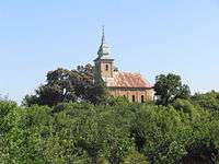 Greek Catholic Church in Abaújszolnok
See also
References
- ↑ A KSH 2012. évi helységnévkönyve
- ↑ népesség.com, "Szikszói járás népessége"
- ↑ 4.1.6.1 A népesség nemzetiség szerint, 2011, (in Hungarian)
- ↑ 4.1.7.1 A népesség vallás, felekezet szerint, 2011, (in Hungarian)
External links
| Town (1) |
| |
|---|---|---|
| Villages (23) | ||