Sátoraljaújhely District
| Sátoraljaújhely District Sátoraljaújhelyi járás | ||
|---|---|---|
| Districts of Hungary | ||
| ||
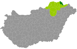 Sátoraljaújhely District within Hungary and Borsod-Abaúj-Zemplén County. | ||
| Country |
| |
| County | Borsod-Abaúj-Zemplén | |
| District seat | Sátoraljaújhely | |
| Area | ||
| • Total | 321.38 km2 (124.09 sq mi) | |
| Area rank | 13th in Borsod-Abaúj-Zemplén | |
| Population (2011 census) | ||
| • Total | 23,058 | |
| • Rank | 9th in Borsod-Abaúj-Zemplén | |
| • Density | 72/km2 (190/sq mi) | |

Sátoraljaújhely (Hungarian: Sátoraljaújhelyi járás) is a district in north-eastern part of Borsod-Abaúj-Zemplén County. Sátoraljaújhely is also the name of the town where the district seat is found. The district is located in the Northern Hungary Statistical Region.
Geography
Sátoraljaújhely District borders with the Slovakian region of Košice to the northeast, Cigánd District and Sárospatak District to the south, Gönc District to the west. The number of the inhabited places in Sátoraljaújhely District is 21.
Municipalities
The district has 2 towns and 19 villages. (ordered by population, as of 1 January 2012)[1]
- Alsóberecki (722)
- Alsóregmec (196)
- Bózsva (183)
- Felsőberecki (273)
- Felsőregmec (322)
- Filkeháza (97)
- Füzér (467)
- Füzérkajata (110)
- Füzérkomlós (331)
- Füzérradvány (318)
- Hollóháza (826)
- Kishuta (272)
- Kovácsvágás (649)
- Mikóháza (576)
- Nagyhuta (89)
- Nyíri (412)
- Pálháza (1,000)
- Pusztafalu (192)
- Sátoraljaújhely (15,355) – district seat
- Vágáshuta (83)
- Vilyvitány (230)
The bolded municipalities are cities.
Demographics
Religion in Sátoraljaújhely District (2011 census)
In 2011, it had a population of 23,058 and the population density was 72/km².
| Year | County population[2] | Change |
|---|---|---|
| 2011 | 23,058 | n/a |
Ethnicity
Besides the Hungarian majority, the main minorities are the Roma (approx. 3,000), Slovak (800), German (200) and Rusyn (150).
Total population (2011 census): 23,058
Ethnic groups (2011 census):[3] Identified themselves: 24,811 persons:
- Hungarians: 20,723 (83.52%)
- Gypsies: 2,780 (11.20%)
- Slovaks: 784 (3.16%)
- Others and indefinable: 524 (2.11%)
Approx. 2,000 persons in Sátoraljaújhely District did declare more than one ethnic group at the 2011 census.
Religion
Religious adherence in the county according to 2011 census:[4]
- Catholic – 11,135 (Roman Catholic – 8,372; Greek Catholic – 2,762);
- Reformed – 4,885;
- Evangelical – 45;
- other religions – 372;
- Non-religious – 2,001;
- Atheism – 106;
- Undeclared – 4,514.
Gallery
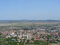 Sátoraljaújhely, the district seat
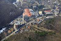 Aerial view of Hollóháza
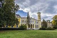 Károlyi Mansion in Füzérradvány
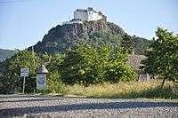 Füzér Castle
See also
References
- ↑ A KSH 2012. évi helységnévkönyve
- ↑ népesség.com, "Sátoraljaújhelyi járás népessége"
- ↑ 4.1.6.1 A népesség nemzetiség szerint, 2011, (in Hungarian)
- ↑ 4.1.7.1 A népesség vallás, felekezet szerint, 2011, (in Hungarian)
External links
| Towns (2) |
| |
|---|---|---|
| Villages (19) | ||
Coordinates: 48°27′00″N 21°31′00″E / 48.4500°N 21.5167°E