Aszaló
| Aszaló | ||
|---|---|---|
.jpg) | ||
| ||
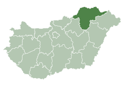
 Location of Borsod-Abaúj-Zemplén county in Hungary | ||
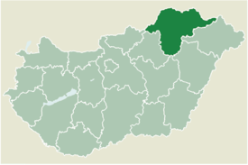
 Aszaló Location of Aszaló | ||
| Coordinates: 48°13′16″N 20°57′38″E / 48.22122°N 20.96064°ECoordinates: 48°13′16″N 20°57′38″E / 48.22122°N 20.96064°E | ||
| Country |
| |
| County | Borsod-Abaúj-Zemplén | |
| Government | ||
| • Mayor | Dr. Mészáros István[1] | |
| Area | ||
| • Total | 25.36 km2 (9.79 sq mi) | |
| Population (2015) | ||
| • Total | 1,843[2] | |
| Time zone | UTC+1 (CET) | |
| • Summer (DST) | UTC+2 (CEST) | |
| Postal code | 3841 | |
| Area code(s) | 46 | |
Aszaló is a village in Borsod-Abaúj-Zemplén county, Hungary.
Location
It is located 18 km northeast of Miskolc in the valley of Hernád.
Access
It is accessible by public transport by Main Route 3 or by train on the Miskolc-Hidasnémeti railway line.
Surrounding settlements
Csobád (9 km), Halmaj (about 6 km), Kazhmar (9 km), and the nearest town Szikszó (5 km).
History
Its first mention was from 1275, under the name of Ozalou. Already in the Middle Ages, there were significant wine production, horses, and beekeepers. In 1553, Ferdinand I plundered it. He later became the ruler of the Nagyvárad. It's been held by either Borsod or Abaúj. In the second half of the 16th century, there was a school in Aszaló.
In 1824 and 1854, fire destroyed the majority of the village, but it was rebuilt both times.
In the 1960s, an air defense artillery missile base and a military base were built in the area, but they were closed in the 1980s.
Ethnic groups
80% of the population of the settlement is Hungarian and 20% of Gypsy origin.[3]
Sights
- a Late Baroque, Roman Catholic church from the 1770s .
- a Reformed church from the late 18th century .
References
- ↑ "Mayoral Election Result in Aszaló". Retrieved 6 December 2017.
- ↑ "Kiadványtár - Központi Statisztikai Hivatal". www.ksh.hu (in Hungarian). Retrieved 6 December 2017.
- ↑ "Központi Statisztikai Hivatal". www.ksh.hu (in Hungarian). Retrieved 6 December 2017.
External links
- Street map (in Hungarian)