Swatara Creek
Coordinates: 40°11′5″N 76°43′56″W / 40.18472°N 76.73222°W
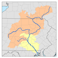
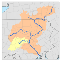
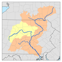
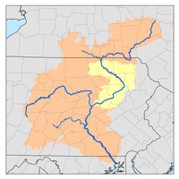
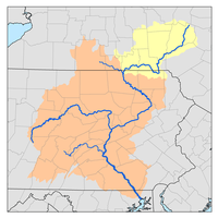
Swatara Creek (nicknamed the Swattie) is a 72-mile-long (116 km)[1] tributary of the Susquehanna River in east central Pennsylvania in the United States. It rises in the Appalachian Mountains in central Schuylkill County and passes through northwest Lebanon Valley before draining into the Susquehanna at Middletown.
The name Swatara is said to derive from a Susquehannock word, Swahadowry or Schaha-dawa, which means 'where we feed on eels'.[2]
Drinking Water
Further, three water companies—United Water , American Water , and the Lebanon Water Authority [www.lebanonauthority.org/] draw drinking water for hundreds of thousands of residents of the Swatara Watershed.
Geography
Swatara Creek rises in the Appalachian Mountains in central Schuylkill County, north of the Sharp Mountain ridge, approximately 5 mi (8.0 km) west of Minersville. It then flows southwest in a winding course, passing south of Tremont, then cutting south through Second Mountain ridge. It passes through Swatara State Park then turns south to pass through Swatara Gap in the Blue Mountain ridge northwest of Lebanon. After emerging from the ridge it flows southwest, north of Hershey, past Hummelstown, and joins the Susquehanna at Middletown. It receives Quittapahilla Creek from the east 3 mi (4.8 km) north of Palmyra.
History
The creek was a significant transportation route in the colonial period of North America up through the late 19th century. A canal linking the Susquehanna and Delaware valleys in southeastern Pennsylvania was first proposed in 1690 by William Penn, the founder of the Pennsylvania Colony. Nearly a century passed before a route for the canal was surveyed by David Rittenhouse and William Smith between 1762 and 1770, the first canal ever surveyed in the U.S. Spurred by the 1791 discovery of anthracite in the upper Susquehanna Valley, the Pennsylvania General Assembly chartered two companies to undertake the project: the Schuylkill and Susquehanna Navigation Company and the Delaware and Schuylkill Navigation Company. At the time of the initial construction in 1792, Philadelphia was involved in an intense rivalry with Baltimore for the supremacy as a shipping port. The canal was backed by Philadelphia businessmen as a means to divert commercial traffic from following the Susquehanna downriver to the Chesapeake Bay, its more natural destination. Although the Schuylkill and Susquehanna Navigation Company project failed for lack of funds, the project was restarted and ultimately completed by its successor company, the Union canal in 1828.
From west to east, the route of the Schuylkill and Susquehanna Navigation Company canal in 1792 was to follow Swatara Creek upstream from Middletown to Quittapahilla Creek, which it then followed upstream past Lebanon and Myerstown to its headwaters. It then crossed overland to Clarks Run at the headwaters of Tulpehocken Creek, following Tulpehocken Creek downstream to Reading on the Schuylkill River. It was to follow the Schuylkill downriver to the Delaware River at Philadelphia. The route of the Union Canal followed the same route up the Swatara Creek and continue up the creek to Union Water Works. The canal then went up Clark's run to the summit and thence by a 729-foot tunnel over to Lebanon. The upper course above Union Water Works into the mountains provided the route of a feeder to the main canal, as well as providing a route to ship anthracite from the mountains to Philadelphia.
On September 8, 2011, The creek reached a record height of 26.8 feet near Hershey, following devastating rains from Tropical Storm Lee and remnants of Hurricane Irene, the highest since measurements began in 1975. Farther upstream at the Harpers Tavern gauge, 24.60' was recorded, making it the worst flooding since 1889. The flooding caused thousands of people to be evacuated from their homes throughout Central Pennsylvania, and at least one death.[3]
Recreation
Today, the Swatara Creek is part of a national and statewide water trail system, providing outdoor recreation and a wellness activity for families canoeing and kayaking a 60-mile segment that connects to the Susquehanna River [www.susquehannawatertrail.org/] and Captain John Smith Water Trails.
Tributaries
- Iron Run
- Beaver Creek (Swatara Creek)
- Spring Creek (Swatara Creek)
- Manada Creek
- Quittapahilla Creek
- Brandywine Creek (Quittapahilla Creek)
- Bow Creek (Swatara Creek)
- Indiantown Run
- Little Swatara Creek
- Lower Little Swatara Creek
- Upper Little Swatara Creek
- Good Spring Creek
Ships
Two ships in the United States Navy have been named USS Swatara after the creek:
- The first USS Swatara (1865) was a wooden, screw sloop, launched in 1865 and dismantled in 1872 to become the second ship of this name.
- The second USS Swatara (1873) was a screw sloop, launched in 1873 and decommissioned in 1891.
See also
References
- ↑ U.S. Geological Survey. National Hydrography Dataset high-resolution flowline data. The National Map, accessed August 8, 2011
- ↑ Kelker, Luther Reily (1907). History of Dauphin County, Pennsylvania. New York: Lewis Publishing. p. 14. Retrieved 2012-10-10.
- ↑ Swatara Creek's record-setting rise Penn Live, September 08, 2011
- U.S. Geological Survey: PA stream gaging stations
- Swatara Creek Water Trail
- Canal Museum: Union Canal
- Swatara Creek Greenway
- Northern Swatara Creek Watershed Association