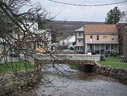
Tremont, Pennsylvania
| Tremont, Pennsylvania | |
|---|---|
| Borough | |
 Tremont | |
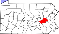
 Location of Tremont in Schuylkill County, Pennsylvania. | |
 Tremont Location in Pennsylvania  Tremont Tremont (the US) | |
| Coordinates: 40°37′48″N 76°23′23″W / 40.63000°N 76.38972°WCoordinates: 40°37′48″N 76°23′23″W / 40.63000°N 76.38972°W | |
| Country | United States |
| State | Pennsylvania |
| County | Schuylkill |
| Settled | 1844 |
| Incorporated | 1866 |
| Government | |
| • Type | Borough Council |
| • Mayor | Roger Adams Sr. |
| Area[1] | |
| • Total | 0.73 sq mi (1.88 km2) |
| • Land | 0.73 sq mi (1.88 km2) |
| • Water | 0.00 sq mi (0.00 km2) |
| Population (2010) | |
| • Total | 1,752 |
| • Estimate (2016)[2] | 1,691 |
| • Density | 2,329.20/sq mi (899.70/km2) |
| Time zone | UTC-5 (Eastern (EST)) |
| • Summer (DST) | UTC-4 (EDT) |
| ZIP code | 17981 |
| Area code(s) | 570 |
| FIPS code | 42-77392 |
Tremont is a borough in Schuylkill County, Pennsylvania, United States. The population was 1,784 at the 2000 census.
Geography
Tremont is located at 40°37′48″N 76°23′23″W / 40.63000°N 76.38972°W (40.630052, -76.389677).[3]
According to the United States Census Bureau, the borough has a total area of 0.8 square miles (2.1 km2), all of it land.
Demographics
| Historical population | |||
|---|---|---|---|
| Census | Pop. | %± | |
| 1870 | 1,709 | — | |
| 1880 | 1,785 | 4.4% | |
| 1890 | 2,064 | 15.6% | |
| 1900 | 1,947 | −5.7% | |
| 1910 | 2,067 | 6.2% | |
| 1920 | 2,015 | −2.5% | |
| 1930 | 2,304 | 14.3% | |
| 1940 | 2,314 | 0.4% | |
| 1950 | 2,102 | −9.2% | |
| 1960 | 1,893 | −9.9% | |
| 1970 | 1,833 | −3.2% | |
| 1980 | 1,796 | −2.0% | |
| 1990 | 1,814 | 1.0% | |
| 2000 | 1,784 | −1.7% | |
| 2010 | 1,752 | −1.8% | |
| Est. 2016 | 1,691 | [2] | −3.5% |
| Sources:[4][5][6] | |||
As of the census[5] of 2000, there were 1,784 people, 695 households, and 442 families residing in the borough. The population density was 2,305.5 people per square mile (894.6/km²). There were 749 housing units at an average density of 968.0 per square mile (375.6/km²). The racial makeup of the borough was 98.99% White, 0.39% African American, 0.06% Native American, 0.06% Asian, 0.06% Pacific Islander, and 0.45% from two or more races. Hispanic or Latino of any race were 0.06% of the population.
There were 695 households out of which 26.8% had children under the age of 18 living with them, 49.2% were married couples living together, 10.1% had a female householder with no husband present, and 36.4% were non-families. 30.5% of all households were made up of individuals and 17.6% had someone living alone who was 65 years of age or older. The average household size was 2.36 and the average family size was 2.95.
In the borough the population was spread out with 20.5% under the age of 18, 7.6% from 18 to 24, 24.4% from 25 to 44, 23.3% from 45 to 64, and 24.3% who were 65 years of age or older. The median age was 43 years. For every 100 females there were 86.0 males. For every 100 females age 18 and over, there were 82.2 males.
The median income for a household in the borough was $30,167, and the median income for a family was $35,326. Males had a median income of $31,542 versus $20,395 for females. The per capita income for the borough was $14,698. About 9.5% of families and 13.1% of the population were below the poverty line, including 28.2% of those under age 18 and 5.5% of those age 65 or over.
References
- ↑ "2016 U.S. Gazetteer Files". United States Census Bureau. Retrieved Aug 14, 2017.
- 1 2 "Population and Housing Unit Estimates". Retrieved June 9, 2017.
- ↑ "US Gazetteer files: 2010, 2000, and 1990". United States Census Bureau. 2011-02-12. Retrieved 2011-04-23.
- ↑ "Census of Population and Housing". U.S. Census Bureau. Retrieved 11 December 2013.
- 1 2 "American FactFinder". United States Census Bureau. Retrieved 2008-01-31.
- ↑ "Incorporated Places and Minor Civil Divisions Datasets: Subcounty Resident Population Estimates: April 1, 2010 to July 1, 2012". Population Estimates. U.S. Census Bureau. Archived from the original on 17 June 2013. Retrieved 11 December 2013.
| Wikimedia Commons has media related to Tremont, Pennsylvania. |