Surwold
| Surwold | ||
|---|---|---|
| ||
 Surwold Location of Surwold within Emsland district 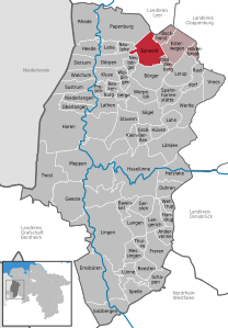  | ||
| Coordinates: 52°57′N 7°31′E / 52.950°N 7.517°ECoordinates: 52°57′N 7°31′E / 52.950°N 7.517°E | ||
| Country | Germany | |
| State | Lower Saxony | |
| District | Emsland | |
| Municipal assoc. | Nordhümmling | |
| Government | ||
| • Mayor | Wilhelm Grote (CDU) | |
| Area | ||
| • Total | 54.89 km2 (21.19 sq mi) | |
| Elevation | 25 m (82 ft) | |
| Population (2017-12-31)[1] | ||
| • Total | 4,261 | |
| • Density | 78/km2 (200/sq mi) | |
| Time zone | CET/CEST (UTC+1/+2) | |
| Postal codes | 26903 | |
| Dialling codes | 0 49 65 | |
| Vehicle registration | EL | |
| Website | www.surwold.de | |

Surwold is a municipality in the Emsland district, in Lower Saxony, Germany.
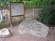
Memorial at the entry site of the former Nazi concentration camp Börgermoor
References
This article is issued from
Wikipedia.
The text is licensed under Creative Commons - Attribution - Sharealike.
Additional terms may apply for the media files.