Spelle
| Spelle | ||
|---|---|---|
| ||
 Spelle Location of Spelle within Emsland district 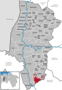  | ||
| Coordinates: 52°22′N 07°28′E / 52.367°N 7.467°ECoordinates: 52°22′N 07°28′E / 52.367°N 7.467°E | ||
| Country | Germany | |
| State | Lower Saxony | |
| District | Emsland | |
| Municipal assoc. | Spelle | |
| Government | ||
| • Mayor | Georg Holtkötter (CDU) | |
| Area | ||
| • Total | 34.2 km2 (13.2 sq mi) | |
| Elevation | 35 m (115 ft) | |
| Population (2017-12-31)[1] | ||
| • Total | 9,309 | |
| • Density | 270/km2 (700/sq mi) | |
| Time zone | CET/CEST (UTC+1/+2) | |
| Postal codes | 48480 | |
| Dialling codes | 0 59 77 | |
| Vehicle registration | EL | |
| Website | www.spelle.de | |

Spelle is a municipality in the Emsland district, in Lower Saxony, Germany. It is situated approximately 20 km southeast of Lingen, and 10 km north of Rheine.
Spelle is also the seat of the Samtgemeinde ("collective municipality") Spelle.
References
This article is issued from
Wikipedia.
The text is licensed under Creative Commons - Attribution - Sharealike.
Additional terms may apply for the media files.