Emsbüren
| Emsbüren | ||
|---|---|---|
| ||
 Emsbüren Location of Emsbüren within Emsland district 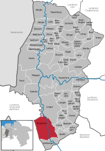  | ||
| Coordinates: 52°23′33″N 07°17′29″E / 52.39250°N 7.29139°ECoordinates: 52°23′33″N 07°17′29″E / 52.39250°N 7.29139°E | ||
| Country | Germany | |
| State | Lower Saxony | |
| District | Emsland | |
| Government | ||
| • Mayor | Bernhard Overberg | |
| Area | ||
| • Total | 139.31 km2 (53.79 sq mi) | |
| Elevation | 43 m (141 ft) | |
| Population (2017-12-31)[1] | ||
| • Total | 10,150 | |
| • Density | 73/km2 (190/sq mi) | |
| Time zone | CET/CEST (UTC+1/+2) | |
| Postal codes | 48488 | |
| Dialling codes | 05903 | |
| Vehicle registration | EL | |
| Website | www.emsbueren.de | |

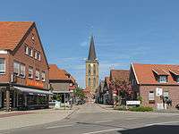
Emsbüren, church (die Sankt Andreaskirche) in the street
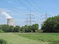
cooling tower of the Emsland Nuclear Power Plant, view from Elbergen
Emsbüren is a municipality in the Emsland district, Lower Saxony, Germany. It is situated on the river Ems, approx. 15 km south of Lingen, and 15 km northwest of Rheine.
It has a railway station: Leschede.
Personalities
- Willi Heeks (1922-1996), German automobile racing driver
- René Tebbel (born 1969), German showjumper
References
This article is issued from
Wikipedia.
The text is licensed under Creative Commons - Attribution - Sharealike.
Additional terms may apply for the media files.