Lehe, Lower Saxony
| Lehe | ||
|---|---|---|
| ||
 Lehe Location of Lehe within Emsland district 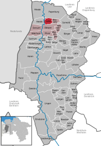  | ||
| Coordinates: 53°00′12″N 07°19′49″E / 53.00333°N 7.33028°ECoordinates: 53°00′12″N 07°19′49″E / 53.00333°N 7.33028°E | ||
| Country | Germany | |
| State | Lower Saxony | |
| District | Emsland | |
| Municipal assoc. | Dörpen | |
| Government | ||
| • Mayor | Johann Mardink (CDU) | |
| Area | ||
| • Total | 17.87 km2 (6.90 sq mi) | |
| Elevation | 6 m (20 ft) | |
| Population (2017-12-31)[1] | ||
| • Total | 988 | |
| • Density | 55/km2 (140/sq mi) | |
| Time zone | CET/CEST (UTC+1/+2) | |
| Postal codes | 26892 | |
| Dialling codes | 04962 | |
| Vehicle registration | EL | |
| Website | www.lehe-ems.de | |
_COA.png)
Lehe is a municipality in the Emsland district, in Lower Saxony, Germany.
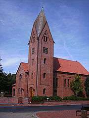
Lehe, church
References
This article is issued from
Wikipedia.
The text is licensed under Creative Commons - Attribution - Sharealike.
Additional terms may apply for the media files.