Lorup
| Lorup | ||
|---|---|---|
| ||
 Lorup Location of Lorup within Emsland district 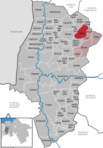  | ||
| Coordinates: 52°55′31″N 7°38′31″E / 52.92528°N 7.64194°ECoordinates: 52°55′31″N 7°38′31″E / 52.92528°N 7.64194°E | ||
| Country | Germany | |
| State | Lower Saxony | |
| District | Emsland | |
| Municipal assoc. | Werlte | |
| Government | ||
| • Mayor | Heinrich Kreutzjans (CDU) | |
| Area | ||
| • Total | 51.22 km2 (19.78 sq mi) | |
| Elevation | 30 m (100 ft) | |
| Population (2017-12-31)[1] | ||
| • Total | 3,191 | |
| • Density | 62/km2 (160/sq mi) | |
| Time zone | CET/CEST (UTC+1/+2) | |
| Postal codes | 26901 | |
| Dialling codes | 0 59 54 | |
| Vehicle registration | EL | |
| Website | www.lorup.de | |

Lorup is a municipality in the Emsland district, in Lower Saxony, Germany.
References
This article is issued from
Wikipedia.
The text is licensed under Creative Commons - Attribution - Sharealike.
Additional terms may apply for the media files.