Mueang Surat Thani District
| Mueang Surat Thani เมืองสุราษฎร์ธานี | |
|---|---|
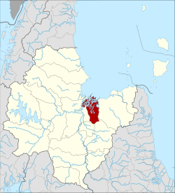 Amphoe location in Surat Thani Province | |
| Coordinates: 9°8′11″N 99°19′13″E / 9.13639°N 99.32028°ECoordinates: 9°8′11″N 99°19′13″E / 9.13639°N 99.32028°E | |
| Country | Thailand |
| Province | Surat Thani |
| Seat | Talat |
| Area | |
| • Total | 233.8 km2 (90.3 sq mi) |
| Population (2012) | |
| • Total | 172,202 |
| • Density | 713.8/km2 (1,849/sq mi) |
| Time zone | UTC+7 (ICT) |
| Postal code | 84000, 84100 |
| TIS 1099 | 8401 |
Mueang Surat Thani (Thai: เมืองสุราษฎร์ธานี, pronounced [mɯ̄a̯ŋ sù.râːt tʰāː.nīː]), formerly named the Ban Don District (Thai: บ้านดอน), is the capital district (amphoe mueang) of Surat Thani Province in southern Thailand.
Geography
The district is at the mouth of the Tapi River, where it flows into Bandon Bay of the Gulf of Thailand. Neighboring districts are (from the east clockwise) Kanchanadit, Ban Na San, Ban Na Doem, and Phunphin.
To the east of the district the Thathong River marks the natural boundary to Kanchanadit, while the boundary to Phunphin is partially marked by the western arm of the Tapi River. Khun Thale is a small lake in the center of the district. The Khao Tha Phet non-hunting area protects 4.65 km2 of a hill south of the city of Surat Thani.
The Khun Thale swamp to the south of the district is the source of two short minor rivers which meander through the city, Khlong Makham Tia and Khlong Tha Kup.
History
The district was formed when in 1897 Mueang Chaiya and Kanchanadit were merged into a single province named Chaiya, with its administrative center at Ban Don.[1] The district was then simply named Mueang. In 1915 the province was renamed Surat Thani.[2] In 1917 the district was renamed Ban Don (บ้านดอน).[3] In 1938 the district was renamed Mueang Surat Thani, when all capital districts were named after their corresponding province.[4]
Administration
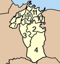
The district is divided into 11 sub-districts (tambon), which are further subdivided into 70 villages (muban). Surat Thani itself is a city (thesaban nakhon) and covers the tambon Talat and Bang Kung, and parts of the tambons Khlong Chanak, Bang Chana, Bang Bai Mai, and Makham Tia. Wat Pradu and Khun Thale have sub-district municipality (thesaban tambon) status, and cover the whole same-named sub-district. There are a further eight tambon administrative organizations (TAO), for each sub-district except the three completely covered by municipalities.
|
 |
References
- ↑ แจ้งความกระทรวงมหาดไทย (PDF). Royal Gazette (in Thai). 16 (29): 428. 1899-10-15.
- ↑ ประกาศ เปลี่ยนนามอำเภอ นามเมืองและนามมณฑล (PDF). Royal Gazette (in Thai). 32 (0 ก): 145–147. 1915-08-08.
- ↑ ประกาศกระทรวงมหาดไทย เรื่อง เปลี่ยนชื่ออำเภอ (PDF). Royal Gazette (in Thai). 34 (0 ก): 40–68. 1917-04-29.
- ↑ พระราชกฤษฎีกาเปลี่ยนนามจังหวัด และอำเภอบางแห่ง พุทธศักราช ๒๔๘๑ (PDF). Royal Gazette (in Thai). 55 (0 ก): 658. November 14, 1938.
- ↑ "Population statistics 2012". Department of Provincial Administration.