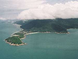
Ko Pha-ngan
| Ko Pha-ngan เกาะพะงัน | |
|---|---|
| island | |
 Ko Pha-ngan | |
 Ko Pha-ngan | |
| Coordinates: 9°43′0″N 100°0′0″E / 9.71667°N 100.00000°E | |
| Country | Thailand |
| Province | Surat Thani |
| Area | |
| • Total | 125 km2 (48 sq mi) |
| Time zone | UTC+7 (ICT) |
Ko Pha-ngan[1] (Thai: เกาะพะงัน; RTGS: phangan; pronounced [kɔ̀ʔ pʰā.ŋān]) is an island in the Gulf of Thailand in southeast Thailand in Surat Thani Province. Ko Pha-ngan is best known for its Full Moon Party at Haad Rin Beach. Ko Pha-ngan has two sister islands: the larger Ko Samui to the south and the smaller Ko Tao to the north.
- Estimated perimeter: 40 km (estimated 10 hr average walking time)
- From mainland: about 55 km
- From Ko Samui: about 15 km
- From Ko Tao: about 35 km
- Main town: Thong Sala
- Highest Point: Khao Ra, 630 m
History
The name Ko Pha-ngan derives from the word "ngan", meaning "sand bar" in the southern dialect, for there are many sand bars offshore.
Ko Pha-ngan has been a longtime favorite of past kings of Thailand. Rama V, or Chulalongkorn, for example, visited Ko Pha-ngan 14 times during his reign.
The Bronze Drum of Dongson Culture (500–100 BCE) that was found on Ko Samui in 1977 is evidence that there were settlements of people on Ko Samui, Ko Pha-ngan, and their islets more than two thousand years ago. Some historians and archaeologists believe that the first group who migrated to Ko Pha-ngan were Muslim sea gypsies (Pygmy, Semung, and Proto-Malay) who travelled by boat from the Malay Peninsula. Today there are few Muslim inhabitants.
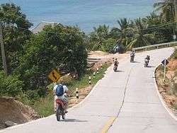
Over the last century the island's population has steadily expanded, first living off the sea and the land and farming coconuts. Later, tin mining became part of the economy. In the 1970s the mining industry faltered and finally petered out. Over the next decade tourism took hold. Now the island is primarily a tourist destination. Fishing and coconut farming remain important to the local economy.
Due to its topography, the population hugs the coastline. The mountainous interior is generally inaccessible. More than half the island designated as national park and Ko Pha-ngan has more than 80 km2 (31 sq mi) of relatively unspoiled rain forest with diverse flora and fauna. It is also considered a spiritual place, with numerous Buddhist temples around the island and a thriving spa, retreat, and meditation industry.
Transport links
Visitors can reach the island by ferry from the mainland from two ports in Surat Thani and one in Chumphon.[2]
Since 2012 Kannithi Aviation (Kan Air) has attempted to construct an airport. Kan Air has spent some 500 million baht to acquire about 32 hectares of land to build a passenger terminal capable of handling 1,000 passengers a day and a 1,095 metre runway to accommodate turboprop aircraft such as Kan Air's ATR 72-600 series. The project, originally estimated at 900 million baht—now estimated to cost two billion baht—has faced inflated costs, delays resulting from the yet-to-be-issued environmental impact assessment and other complications, which pushed back initial plans to open in 2014. Kan Air's president claimed the airport would be open by the end of 2017.[3]
Administration
Central administration
Ko Pha-ngan together with Ko Tao and a few minor islands forms the district (amphoe) Ko Pha-ngan (148 km2). The district is subdivided into 3 subdistricts (Tambon), which are further subdivided into 17 administrative villages (Muban).
| No. | Name | Thai | Villages | Pop.[4] |
|---|---|---|---|---|
| 1. | Ko Pha-ngan | เกาะพะงัน | 8 | 10,094 |
| 2. | Ban Tai | บ้านใต้ | 6 | 4,865 |
| 3. | Ko Tao | เกาะเต่า | 3 | 2,357 |
Local administration
There are 4 subdistrict municipalities (Thesaban Tambon) in the district:
- Ko Pha-ngan (Thai: เทศบาลตำบลเกาะพะงัน) consisting of parts of the subdistricts Ko Pha-ngan and Ban Tai.
- Phet Pha-ngan (Thai: เทศบาลตำบลเพชรพะงัน) consisting of parts of the subdistrict Ko Pha-ngan.
- Ban Tai (Thai: เทศบาลตำบลบ้านใต้) consisting of parts of the subdistrict Ban Tai.
- Ko Tao (Thai: เทศบาลตำบลเกาะเต่า) consisting of the complete subdistrict Ko Tao.
History
Originally the island was administered from Ko Samui District. The minor district (king amphoe) Ko Pha-ngan was established on 1 October 1970, then consisting of the two tambon, Ko Pha-ngan and Ban Tai.[5] It was upgraded to a full district on 12 April 1977.[6] Ko Tao subdistrict was established on August 15 1982 by splitting off three administrative villages from Ko Pha-ngan subdistrict.[7]
Environmental issues
As of 2018 the island receives about 458,000 visitors per year. They and the island residents generate about 7,300 tonnes of solid waste per year. Untreated wastewater discharges and on-going coral bleaching are also issues.[8]
In popular culture
Ko Pha-ngan featured prominently in Alex Garland's 1996 novel The Beach and is also mentioned in the 2006 song Magick by the new rave band Klaxons (but probably more as a reference to the 1996 novel The Beach than the island itself).
The Full Moon Party is a monthly dance music festival set on Haad Rin Nok Beach scheduled every month at full moon. The event primarily features electronic music and attracts around 30,000 party-goers in a normal month.[9] Recently steps have been taken to make Ko Pha-ngan into a more family-friendly tourist destination, promoting the island's wealth of natural attractions and also stepping up the police presence; road blocks with stop and search procedures are commonplace and undercover police also patrol parties.
There is also a Half Moon Party held every month at half moon. While the full moon party takes place on the beach at Haad Rin Nok, the half moon party takes place in the jungle inland from Ban Tai, requiring Tuk-Tuk, taxi or bike transport to and from.
The song "Vision in Blue" on the album The Golden Ratio by Ace of Base mentions Ko Pha-ngan.
DJ/producer Ashley Wallbridge titled his 2012 song "Kopanang", an anglicized version of Ko Pha-ngan.[10]
The British psychedelic rock band Ozric Tentacles featured a song called Ko Pha-ngan on their 1989 album The Bits Between The Bits.
In 2016, Infected Mushroom collaborated with Hatikva 6 to release a song called "Hotel Koh Phangan."
See also
References
- ↑ ประกาศราชบัณฑิตยสถาน เรื่อง การเขียนชื่อจังหวัด เขต อำเภอ และกิ่งอำเภอ (PDF). Royal Gazette (in Thai). 117 (พิเศษ 94 ง): 2. 14 Sep 2000.
- ↑ "LOMPRAYAH ROUTE". Lomprayah High Speed Ferries Co., Ltd. Retrieved 9 April 2018.
- ↑ Kositchotethana, Boonsong (5 September 2016). "Koh Phangan airport developer seeks loans". Bangkok Post. Retrieved 6 September 2016.
- ↑ "Population statistics 2017" (in Thai). Department of Provincial Administration. Retrieved 2018-04-09.
- ↑ ประกาศกระทรวงมหาดไทย เรื่อง แบ่งท้องที่ตั้งเป็นกิ่งอำเภอ (PDF). Royal Gazette (in Thai). 87 (90 ง): 2790. 24 Sep 1970.
- ↑ พระราชกฤษฎีกาตั้งอำเภอปลายพระยา อำเภอห้วยเม็ก อำเภอละแม อำเภอแม่จริม อำเภอหนองกี่ อำเภอโคกปีบ อำเภอเกาะพะงัน อำเภอสนม อำเภอโซ่พิสัย อำเภอโนนสะอาด และอำเภอนาจะหลวย พ.ศ. ๒๕๒๐ (PDF). Royal Gazette (in Thai). 94 (31 ก): 326–330. 12 Apr 1977.
- ↑ "ประกาศกระทรวงมหาดไทย เรื่อง ตั้งและเปลี่ยนแปลงเขตตำบลในท้องที่อำเภอเกาะพะงัน กิ่งอำเภอบ้านนาเดิม อำเภอบ้านนาสาร จังหวัดสุราษฎร์ธานี" (PDF). Royal Gazette (in Thai). 99 (130 ง): 3671–3675. 1982-09-14.
- ↑ Chaolan, Supapong; Wipatayotin, Apinya (8 April 2018). "Islands seek clean break from trail of tourist trash". Bangkok Post. Retrieved 9 April 2018.
- ↑ Hunwick, Robert Foyle (2014-06-27). "The Worst Party in Asia". Slate. Retrieved 2015-01-16.
- ↑ http://fluxbpmonline.blogspot.com/2012/03/interview-with-dj-producer-ashley_16.html
External links
| Wikimedia Commons has media related to Ko Pha-ngan. |

- Department of Provincial Administration (DOPA) Population figures