Strandfontein, Matzikama
| Strandfontein | |
|---|---|
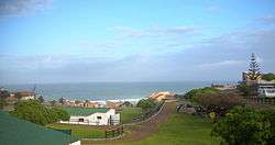 Strandfontein camp site | |
 Strandfontein  Strandfontein Strandfontein (South Africa)  Strandfontein Strandfontein (Africa) | |
| Coordinates: 31°45′20″S 18°13′38″E / 31.75556°S 18.22722°ECoordinates: 31°45′20″S 18°13′38″E / 31.75556°S 18.22722°E | |
| Country | South Africa |
| Province | Western Cape |
| District | West Coast |
| Municipality | Matzikama |
| Area[1] | |
| • Total | 4.18 km2 (1.61 sq mi) |
| Population (2011)[1] | |
| • Total | 431 |
| • Density | 100/km2 (270/sq mi) |
| Racial makeup (2011)[1] | |
| • Black African | 50.6% |
| • Coloured | 14.8% |
| • Indian/Asian | 0.9% |
| • White | 33.2% |
| • Other | 0.5% |
| First languages (2011)[1] | |
| • Afrikaans | 69.4% |
| • Xhosa | 22.6% |
| • English | 3.2% |
| • Sotho | 2.7% |
| • Other | 2.2% |
| Time zone | UTC+2 (SAST) |
| Postal code (street) | 7798 |
| PO box | 7788 |
Strandfontein is a coastal village in the Matzikama Municipality, in the Western Cape province of South Africa. According to the 2011 census it has 431 residents in 92 households.[1] It lies on the Atlantic coast to the south of the mouth of the Olifants River,[2] 240 kilometres (150 mi) north of Cape Town. The name is Afrikaans for "beach spring".[3]
References
- 1 2 3 4 5 "Main Place Strandfontein". Census 2011.
- ↑ Truter, Cornel (1995). West Coast Tourist Guide. Cape Town: University of Cape Town Press. ISBN 978-1-919713-24-3.
- ↑ "Dictionary of Southern African Place Names (Public Domain)". Human Science Research Council. p. 419.
Municipalities and communities of West Coast District Municipality, Western Cape | ||
|---|---|---|
District seat: Moorreesburg | ||
| Matzikama | .svg.png) | |
| Cederberg | ||
| Bergrivier | ||
| Saldanha Bay | ||
| Swartland | ||
This article is issued from
Wikipedia.
The text is licensed under Creative Commons - Attribution - Sharealike.
Additional terms may apply for the media files.