Grotto Bay
| Grotto Bay, South Africa | |
|---|---|
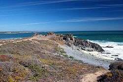 The coast at Grotto Bay | |
 Grotto Bay, South Africa  Grotto Bay, South Africa Grotto Bay, South Africa (South Africa)  Grotto Bay, South Africa Grotto Bay, South Africa (Africa) | |
| Coordinates: 33°30′05″S 18°19′09″E / 33.50139°S 18.31917°ECoordinates: 33°30′05″S 18°19′09″E / 33.50139°S 18.31917°E | |
| Country | South Africa |
| Province | Western Cape |
| District | West Coast |
| Municipality | Swartland |
| Area[1] | |
| • Total | 0.80 km2 (0.31 sq mi) |
| Population (2011)[1] | |
| • Total | 220 |
| • Density | 280/km2 (710/sq mi) |
| Racial makeup (2011)[1] | |
| • Black African | 6.8% |
| • Coloured | 0.9% |
| • White | 85.5% |
| • Other | 6.8% |
| First languages (2011)[1] | |
| • English | 51.4% |
| • Afrikaans | 43.6% |
| • Sotho | 1.8% |
| • Tswana | 1.8% |
| • Other | 1.4% |
| Time zone | UTC+2 (SAST) |
Grotto Bay is a settlement in West Coast District Municipality in the Western Cape province of South Africa.
References
- 1 2 3 4 "Main Place Grotto Bay, South Africa". Census 2011.
Municipalities and communities of West Coast District Municipality, Western Cape | ||
|---|---|---|
District seat: Moorreesburg | ||
| Matzikama | .svg.png) | |
| Cederberg | ||
| Bergrivier | ||
| Saldanha Bay | ||
| Swartland | ||
This article is issued from
Wikipedia.
The text is licensed under Creative Commons - Attribution - Sharealike.
Additional terms may apply for the media files.