Stony Brook station (LIRR)
Stony Brook | |||||||||||||||||||||
|---|---|---|---|---|---|---|---|---|---|---|---|---|---|---|---|---|---|---|---|---|---|
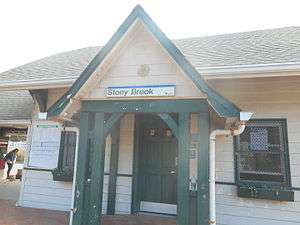 The Stony Brook station house as seen from the south side of NY 25A. | |||||||||||||||||||||
| Location |
New York State Route 25A & Chapman Street Stony Brook, New York | ||||||||||||||||||||
| Coordinates | 40°55′12.99″N 73°7′42.65″W / 40.9202750°N 73.1285139°WCoordinates: 40°55′12.99″N 73°7′42.65″W / 40.9202750°N 73.1285139°W | ||||||||||||||||||||
| Owned by | MTA | ||||||||||||||||||||
| Line(s) | |||||||||||||||||||||
| Platforms | 2 side platforms | ||||||||||||||||||||
| Tracks | 2 | ||||||||||||||||||||
| Connections |
| ||||||||||||||||||||
| Construction | |||||||||||||||||||||
| Parking | Yes | ||||||||||||||||||||
| Bicycle facilities | Yes | ||||||||||||||||||||
| Disabled access | Yes | ||||||||||||||||||||
| Other information | |||||||||||||||||||||
| Fare zone | 10 | ||||||||||||||||||||
| History | |||||||||||||||||||||
| Opened | 1873 | ||||||||||||||||||||
| Rebuilt | 1917, 2010–2011 | ||||||||||||||||||||
| Traffic | |||||||||||||||||||||
| Passengers (2006) | 1,448[2] | ||||||||||||||||||||
| Services | |||||||||||||||||||||
| |||||||||||||||||||||
Stony Brook is a historic station on the Port Jefferson Branch of the Long Island Rail Road. It is located in Stony Brook, New York on the southeast side of New York State Route 25A, across the street from the intersection of Route 25A with Cedar Street. On the opposite side of the tracks is the State University of New York at Stony Brook. There is also a gated at-grade pedestrian crossing between the station and a parking lot at the University. The station is one of only two such stations on the Long Island Rail Road to exclusively feature such crossings, the other being Westwood. This train station is located in the Three Village Central School District.
History
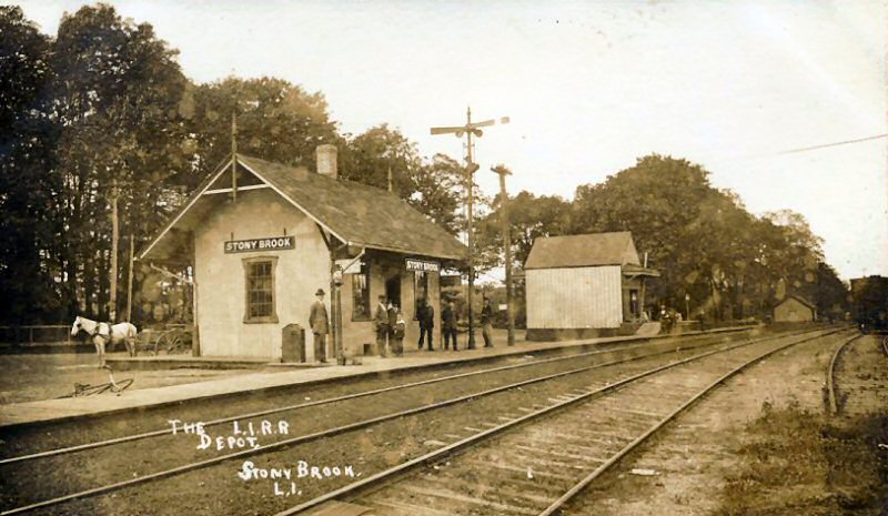
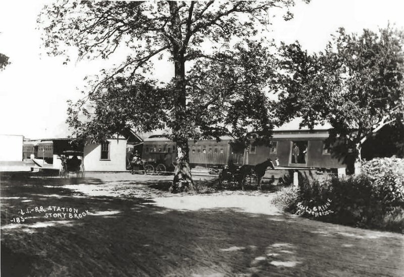
Stony Brook station was built in 1873 by the Smithtown and Port Jefferson Railroad (although some sources have claimed it was built in 1888), and rebuilt in 1917.[3][4] Despite the impact of the arrival of Stony Brook University in 1957, the station has remained a small one-story depot. Parking has always been limited, but efforts to increase capacity at the station have been attempted both by SUNY and NYSDOT.
When the Flowerfield station (to the west) closed in 1958 and the Setauket station (to the east) closed in 1980, Stony Brook station became the penultimate station on the Port Jefferson Branch. High-level platforms and a track realignment took place in the late-1980s.[5] Beginning in April 2010, the Metropolitan Transportation Authority planned a renovation project that was intended to last until January 2011.[6]
Station layout
More frequent service is provided on Track 2. On both ends of the station, the two tracks merge into one. Between 1986 and 1988, high level platforms were added and the two tracks were slightly realigned, now a pretty good distance away from the station building.
| Ground/platform level Exit/entrance, parking, and pedestrian bridge | |
| Platform A, doors will open on the right | |
| Track 1 | ← Port Jefferson Branch toward Huntington, Jamaica, Atlantic or Penn (St. James) Port Jefferson Branch toward Port Jefferson (Terminus) → |
| Track 2 | ← Port Jefferson Branch toward Huntington, Jamaica, Atlantic or Penn (St. James) Port Jefferson Branch toward Port Jefferson (Terminus) → |
| Platform B, doors will open on the right | |
References
- ↑ http://smarttransit.cewit.stonybrook.edu/smarttransit/
- ↑ Average weekday, 2006 LIRR Origin and Destination Study
- ↑ Port Jefferson Branch Stations (Unofficial LIRR History Website)
- ↑ Morrison, David D.; Pakaluk, Valerie (2003). Long Island Rail Road Stations. Images of Rail. Chicago: Arcadia Publishing. p. 80. ISBN 0-7385-1180-3. Retrieved 2011-11-25.
- ↑ Eastbound view of Stony Brook Station track project in 1988, by John Volpi (TrainsAreFun.com)
- ↑ Stony Brook Station Renovations Underway (MTA)
External links

- Official LIRR station information page for Stony Brook