Stelvio Pass
| Stelvio Pass | |
|---|---|
|
Italian: Passo dello Stelvio[1] Lombard: Giogo dello Stèlvio[2] German: Stilfser Joch[1][2] | |
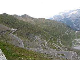 Some of the 48 hairpin turns near the top of the eastern ramp of the Stelvio Pass | |
| Elevation | 2,757 m (9,045 ft) |
| Traversed by | Strada Statale 38 |
| Location |
Border of South Tyrol and Sondrio provinces, Italy |
| Range | Eastern Alps |
| Coordinates | 46°31′43″N 10°27′10″E / 46.52861°N 10.45278°ECoordinates: 46°31′43″N 10°27′10″E / 46.52861°N 10.45278°E |
 Stelvio Pass Location of Stelvio Pass in the Alps. | |
The Stelvio Pass (Italian: Passo dello Stelvio [passo ˈdello ˈstɛlvjo], Lombard: Giogo dello Stèlvio [dʒɔgo ˈdello ˈstɛlvjo]; German: Stilfser Joch; [ˈʃtɪlfsɐ jɔx])[1][2] is a mountain pass in northern Italy bordering Switzerland at an elevation of 2,757 m (9,045 ft) above sea level. It is the highest paved mountain pass in the Eastern Alps, and the second highest in the Alps, 13 m (43 ft) below France's Col de l'Iseran (2,770 m (9,088 ft)).
Location
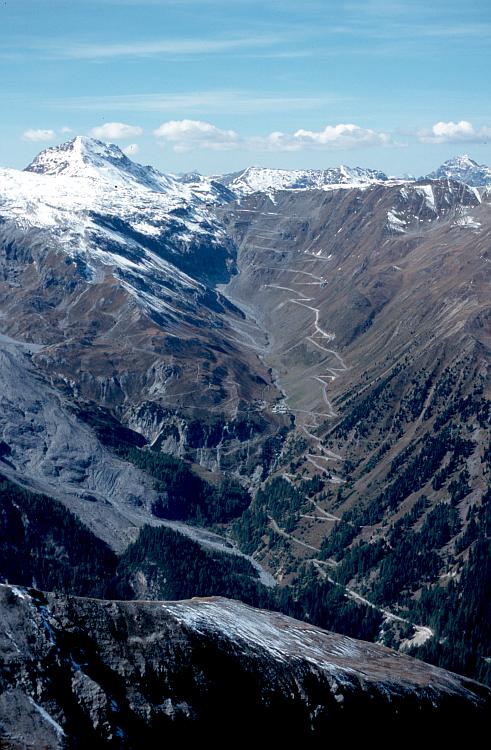
The pass is located in the Ortler Alps in Italy between Stilfs ("Stelvio" in Italian) in South Tyrol and Bormio in the province of Sondrio. It is about 75 km (47 mi) from Bolzano and a mere 200 m from the Swiss border. The Umbrail Pass runs northwards from the Stelvio's western ramp, and the "Three Languages Peak" (Dreisprachenspitze) above the pass is so named because this is where the Italian, German, and Romansh languages meet.
The road connects the Valtellina with the mid Venosta valley (the Vinschgau) and Meran. Adjacent to the pass road there is a large summer skiing area. Important mountains nearby include Ortler, Thurwieserspitze, Trafoier Eiswand, de:Monte Scorluzzo, Piz Umbrail, and Piz Cotschen/Rötlspitz/Punta Rosa.[3]
Stelvio Bike Day
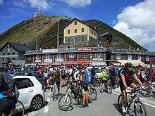
Each year on the last Saturday of August or first Saturday of September the Stelvio National Park administration organizes the Stelvio Bike Day. On that day the roads from Bormio and Prad to the pass, as well as the road from Santa Maria Val Müstair to the Umbrail Pass are closed to all traffic except for bicycles. On average around 12,000 cyclists participate in the Bike Day, with the majority taking the road from Prad to the pass and the descent over the Umbrail pass to Val Müstair.
Since 2017 there has also been a Stelvio Marathon for runners, from Prad to Glurns, back to Prad and thence through Stilfs (Stelvio village) to the pass. The first was held on June 17, 2017, with over 300 participants, and the second is scheduled for June 16, 2018.[4]
History

The original road was built in 1820–25 by the Austrian Empire to connect the former Austrian province of Lombardy with the rest of Austria, covering a climb of 1,871 m (6,138 ft) The engineer and project manager was Carlo Donegani (1775–1845). Since then, the route has changed very little. Its seventy-five hairpin turns, 48 of them on the northern side numbered with stones, are a challenge to motorists. Stirling Moss went off the road here during a vintage car event in the 1990s, with an onboard video of his incident being shown on satellite TV.
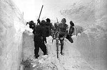
Before the end of World War I, it formed the border between the Austro-Hungarian Empire and the Italian Kingdom. The Swiss had an outpost and a hotel (which was destroyed) on the Dreisprachenspitze (literally, Three-Language-Peak). During World War I, fierce battles were fought in the ice and snow of the area, with gun fire even crossing the Swiss area at times. The three nations made an agreement not to fire over Swiss territory, which jutted out in between Austria (to the north) and Italy (to the south). Instead they could fire down the pass, as Swiss territory was up and around the peak.[5][6] After 1919, with the expansion of Italy, the pass lost its strategic importance.
The Stelvio Pass remains important for sport when it is open from May through November.[7] Countless cyclists and motorcyclists struggle to get to the highest stretch of road in the Eastern Alps. It is the highest finish of any Grand Tour.[8] The Giro d'Italia often crosses the Stelvio Pass (it was crossed by the Giro for the first time in 1953, when Coppi beat Koblet). As the highest peak, it has been named the Cima Coppi in each edition. The last winner on the pass was Mikel Landa Meana in 2017. Every year, the pass is closed to motor vehicles on one day in late August when about 8,000 cyclists ride and around 25 runners run to the top of the Stelvio.
Bormio regularly hosts World Cup ski racing, usually in late December for a men's downhill event; its Pista Stelvio is among the most challenging courses on the circuit.
The Stelvio Pass was also picked by the British automotive show Top Gear as its choice for the "greatest driving road in the world", although their search was concentrated only in Europe.[9][10][11] This conclusion was reached in the first episode of the show's 10th series after the team went in search of a road that would satisfy every "petrolhead's" driving fantasies. Top Gear later decided that the Transfăgărășan Highway in Romania was a superior driving road.
In 2008, Moto Guzzi started selling a Stelvio model, named after the pass. Alfa Romeo debuted its Stelvio crossover SUV at the 2016 Los Angeles Motor Show.
The Stelvio Pass Glacier in Italy, at an altitude of 3,450 metres (11,320 ft), normally permits skiing year-round, but was closed to skiing for the first time in 90 years in August 2017 due to a heatwave.[12].
Appearances in Giro d'Italia (since 1953)
| Year | Stage | Category | Start | Finish | Leader at the summit |
|---|---|---|---|---|---|
| 1953 | 20 | - | Bolzano | Bormio | |
| 1956 | 20 | - | Sondrio | Merano | |
| 1961 | 20 | - | Trento | Bormio | |
| 1965 | 20 | Cima Coppi | Madesimo | Passo dello Stelvio | |
| 1972 | 17 | Cima Coppi | Livigno | Passo dello Stelvio | |
| 1975 | 21 | Cima Coppi | Alleghe | Passo dello Stelvio | |
| 1980 | 20 | Cima Coppi | Cles | Sondrio | |
| 1994 | 15 | Cima Coppi | Merano | Aprica | |
| 2005 | 14 | Cima Coppi | Neumarkt | Livigno | |
| 2012 | 20 | Cima Coppi | Val di Sole | Passo dello Stelvio | |
| 2014 | 16 | Cima Coppi | Ponte di Legno | Val Martello (Martelltal) | |
| 2017 | 16 | Cima Coppi | Rovetta | Bormio |
See also
Notes
- 1 2 3 "GeoCatalogo" (Map). Rete civica dell'Alto Adige. Bolzano, Italy: Provincia Autonoma di Bolzano - Alto Adige. Retrieved 2017-05-30.
- 1 2 3 "39 - Flüalapass" (Map). Giogo dello Stèlvio (2012 ed.). 1:100 000. National Map 1:100'000. Berne, Switzerland: Federal Office of Topography - swisstopo. 2008. Retrieved 2017-05-29 – via map.geo.admin.ch.
- ↑ "Monte Scorluzzo : Climbing, Hiking & Mountaineering". SummitPost. Retrieved 2010-12-02.
- ↑ "2. Stilfserjoch Marathon - Stelvio Marathon". www.stelviomarathon.it.
- ↑ "WWI Isonzo Front, the Soča Valley, Slovenia". Slovenia-Walking. Retrieved 2010-12-02.
- ↑ "The Stelvio pass". Bormio3.com. Retrieved 2010-12-02.
- ↑ "Stelvio Pass - Webcam and info". Gestione tecnica e organizzativa AD S.R.L. Retrieved 2016-07-23.
- ↑ "Yahoo". Yahoo.
- ↑ "Top Gear's World's Best Driving Road in detail at redlineblog – Indian Car Reviews". Redlineblog.com. 2007-11-01. Retrieved 2010-12-02.
- ↑ "3. Stelvio Pass / South Tyrol / Italy Mountain Pass Driving Route and Map in TOP 10 DRIVES Region : Driving Breaks". Ultimatedrives.net. Retrieved 2010-12-02.
- ↑ "Day 4 of The Great European Rally 2015 - Stelvio Pass as featured on Top Gear!". thegreatrally.com. Retrieved 2014-06-03.
- ↑ "What is the 'Lucifer' heatwave where's the hottest weather and what's the latest forecast?". 14 August 2017.
References
- Harrison, Greg, "Over the Top; Motorcycle touring in the Alps", American Motorcyclist, pp. 41+, retrieved 2011-01-03
- Coleman, Colette (2008), Planet Earth's Greatest Motorcycle Adventure Tours, MBI Publishing Company, pp. 174+, ISBN 0-7603-3545-1
External links
| Wikimedia Commons has media related to Passo dello Stelvio. |
- Stelvio National Park
- Stelvio Bike Day
- The Great European Rally drives down Stelvio Pass every year with up to 100 cars taking part.
- Stelvio. Crossroads of Peace
- Profile on climbbybike.com
- Photos Hairpins, Map, and Cycling Elevation Profile
- Michelin map of 23032 Passo dello Stelvio
- Photo of Stilfser Joch north ramp and Monte Scorluzzo